INTRO: A common theme I run across is what was "up" with the long ago interest in geologic sites to the point where they were attractions and, in some cases, giving them names that almost gave them an "identity" all their own. Many of us living in a modern age of technological wonders have allowed one of our most valuable assets - imagination - to grow old and stale.
Oh, it's still there, waiting for those willing to exercise that ability...
Secret of the Rocks
Scattered across the broad landscape of Massachusetts and Rhode Island are an enormous number of natural - and some not so natural - features. Capturing the attention, and sometimes the imagination, of even the States' earliest inhabitants, they comprise a veritable hidden trove of treasures!
Some are rightfully classed as historic sites, others are occasionally known as Victorian, or Gilded Age attractions, harkening back to a period of time when their interest was at its peak. Others came to light during an era when motor coaching was gaining popularity and postcard collecting was in its Golden Era.
Sadly, some sites no longer exist. Others have 'fallen silent' as the society that bore them 'life' has moved on to other pursuits. Here, they will be given a chance to tell their story one more time...
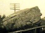
Boulder # 29 @ Dogtown
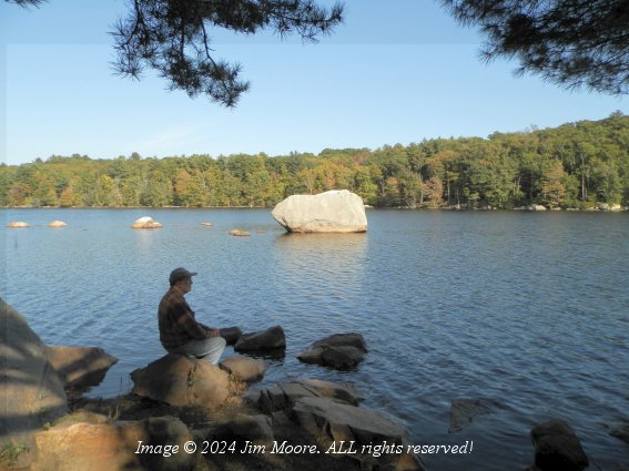
Early morn @ Sea Rocks
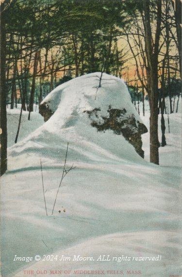
Rare snowless view of the Old Man - early 1900s postcard
Traditional view of the Old Man - early 1900s postcard
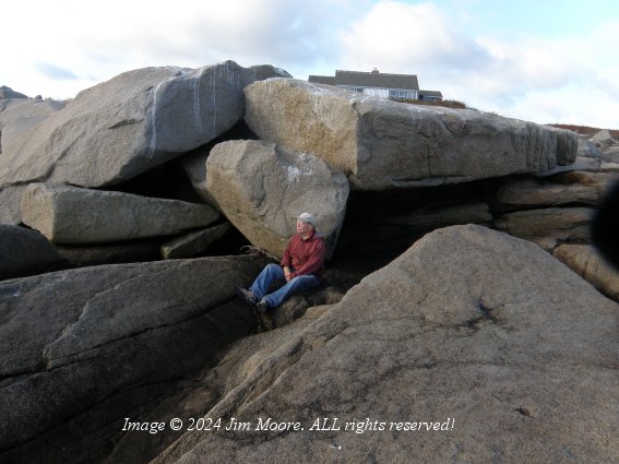
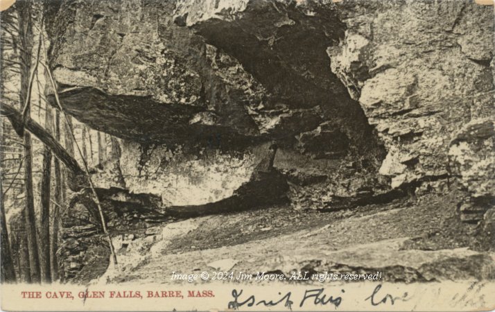
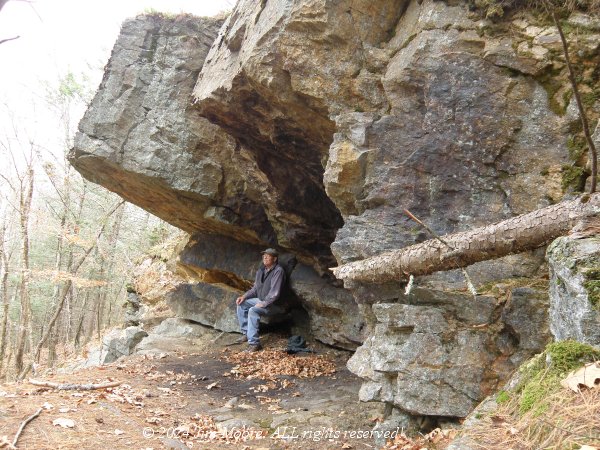
The Cave - early 1900s postcard
The Cave - present day
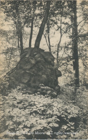
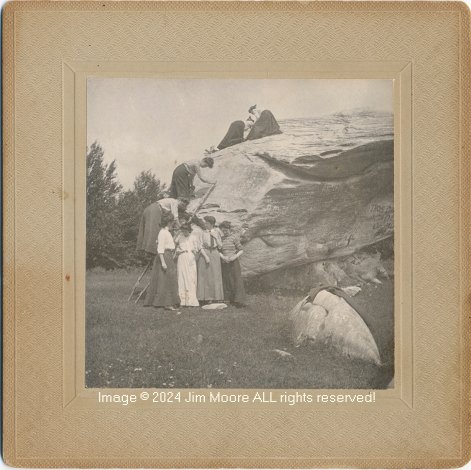
Cradle Rock
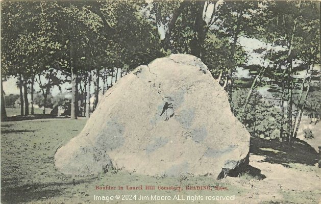
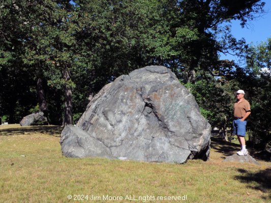
Boulder @ cemetery - early 1900s postcard
Boulder @ cemetery - present day
Both labeled Camp Phyllis, Pontoosuc Lake 1902. Likely Balance Rock in Lanesborough
Activities Synopsis:
'24
October 7, 2024
With a bit of a 'landmark' birthday under my belt, it seems a good time for a long overdue update.
Most know the past four years or so, I've involved myself with regional hiking group the Western Mass Hilltown Hikers. Long distant trips have become far and few between. An exception was made recently that took me to 'old stomping grounds', first at the Middlesex Fells then on up into Essex County. The first day was fraught with all sorts of logistical problems cause by a GPS breakdown. By the next day I had the resources of a phone app to assist me. So my only site I took in on Day1 was a follow up search for possible remains of the Old Man of the Fells. I had culled information from a Facebook post which led me to its approximate former site. Nothing here looked to be a possibility. I eventually wound my way up to North Andover to spend the night at Harold Parker State Forest.
I started out Day 2 with some solid information on Cradle Rock in Groveland. This boulder seemed to gain its 'fame' from the 1890s book by John Henry Sears on Essex County geology. I had a map pointing out its location and even a rare stereoview of the rock. The short story is a home is being build on that site indicated on the map. Interesting is a nice rock sits out front of the house which would have made a dandy of a pedestal. What happened to Cradle Rock remains a mystery.
Using the rest of the day, I hit Cape Ann setting up camp at my usual location. But first catching Lanes Cove, an old friend, and a short walk through Andrews Woods. In the 'Golden Age' of Pigeon Cove much of the land had been dived up into lots for homes. It never totality came to fruition and some of Andrews Woods is part of that property I investigated. A street called Woodside Ave exists on old maps but it seems to have been absorbed into the trails at Andrews Woods. Nearby I took my traditional walk along the Atlantic Path allowing plenty of time to ponder the Ocean. Many features from olden days - including early quarry workings - were passed. Along the way was Chapin's Gully and I ended my romp at the Great Gargoyle. But before heading back to set up camp, I checked the water level at Goose Cove Reservoir for possible access to Boulder #29. The reservoir was quite full and #29 lay a bit off shore surrounded by water.
Starting the third day I made one trip off the Cape. This time to Salem to revisit the Willows. I had wondered if willow trees still existed at this (still) popular early era attraction. Indeed a good number still existed and I got the opportunity to walk some shoreline while the tide was still towards the low side. Sliding in to Dowtown's outer perimeter, I looked in on a cave show to be some years back by a former resident. Then on to the shoreline around high tide and went to look up George Washington's face and Money Rock.
Starting out Day 4, I once again went into the outer perimeter of Dogtown to find an abandoned quarry likely used building the rail line in the area. I had a bit of a time finding the old quarry but realized high waters/flooding prevented me from a direct access. Bushwhacking out, I returned to my entrance trail by the Help Mother boulder. Moving out I headed down to Stage Fort Park along with Half Moon and Cressy Beach. Then a bit south to Magnolia and Rafes Chasm Park. Returning to Rockport, I had wanted to revisit Mill Brook Meadow and Pond. Millbrook has a long history from fishing by the Algonquins to an early grist mill. I finished up quietly visiting a nearby cemetery and the grave of two Rockport residents. Parents to a friend.
My last full day had me out at the tip of Cape Ann and the Babson Quarry. Although in reality I was gaining access to the Sea Rocks property and its giant ocean side boulders/pseudo caves. A quick look followed at Profile Rock which always needs vegetation removal. It is forever trying to fade into the growth upon a hill that once was famous for it's open view of Pigeon Cove. I moved back down to Dogtown one more time to hit a second cave found some years back. The day was finished off at Sunset Hill (also: Pole - or Poles - Hill) in the Riverdale section of Gloucester.
For the final day it only remained to see when the rain would move in. Fortunately it gave me enough time to pull up camp. Unfortunately, it ended my ramblings for this trip. I decamped to the Berkshires!
March 11, 2024
Until such time comes where I can write these out more fully, here is the latest from my end.
Mar 11 Chester Saw property work day
Mar 9 Lee Two additional sections on the Huckleberry Trolley Line
Mar 8 Lee Library Several sites and sections on the Huckleberry Trolley Line
Mar 1 Adams Greylock Glen Pulpit Rock
Feb 24 Chester Ingell Cemetery and H. Newman Marsh; Cemetery
Feb 3 Otis old Bowe/Williams Quarry
Jan 27 Chesterfield Gorge
Jan 26 Becket Chester-Becket RR Line; boulder quarries
Jan 12 Becket Chester-Becket RR Line Mitchell Quarry
Jan 6 Egremont Jug End
Jan 4 Chester Saw Property
Jan 3 Sandisfield CSLs Writing rock
Jan 1 Chester First Day Hike @ Sanderson Brook Falls
Dec 29 Blandford Abandoned roads, box factory remains, cellar holes
Dec 23 Dalton The Prairie
Dec 21 Chester Saw property
Dec 16 Sandisfield York Lake CCC Memorial Service
Dec 15 Westhampton Manhan mine sites (2)
Dec 14 Chester Saw Property
Dec 8 Becket Old Quarry Chester Wright Mine
Nov 30 Blandford Herrick Road trails Sunset Rock Road Soapstone investigations
Nov 24 Chester Sackett Mine
Nov 23 Chester Thanksgiving
Nov 18 Lanesborough Constitution Hill & cave; Widow Whites & Baker's Quarry, Disappearing brook caves
Nov 16 Chester Parts of the Chester-Becket rail line; Marcia Mine
Nov 14 Dover NY Stone Church Cave
Nov 12 Chester Saw property
Nov 10 Chester Hampden St Park RR line Mines
Nov 3 Westfield Pitcher Street & trail
Nov 2 Becket Trolley line pre hike
'23
October 27, 2023
This returned us to the general area of the Potholes, located in the Jacob's Ladder region, explored a couple times in the past. But we brought along a cellar hole expert to scope out a number of previously unknown/unseen cellar remains. The area had been logged and traveling was rough. One member had not yet seen the Potholes so he headed off with another knowledgeable member to look at that. The rest of us picked our war through a heavily rutted forest roads back to our cars.
October 26, 2023
I joined hike leader Liz for a look at the Shatterack Trail leading from Montgomery into Russell and eventually Unkamit's Path. Frankie the Frenchie provided the necessary moral support! Besides the outstanding views this ridge offers, there are also magnificent outcrops of minerals. We did notice the trail was in need of general maintenance.
The hike went as far as Fish Rock, just after where Unkamit's makes it's way steeply up from Russell's Carrington Road.
October 22, 2023
This was the first of a couple 'pre-hikes' for an upcoming Hilltown Hiker group hike. The area focused on the old Huckleberry Trolley route north of Jacob's Ladder in Becket, to almost the the Mass Pike. Each trip often brings 'new' discoveries!
October 19, 2023
A chance to finally catch a great trail system down at Stanley Park in Westfield! Much of the trails run close to the Westfield River and old millstones from Tekoa Mountain and Falley's gun were placed here. There were a number of more 'local attractions' including memorials such as the Prayer Boulder. Of course, what would a park be without a pond and its ducks!
October 14, 2023
This particular hike with the Hilltowen Hikers encompassed Ashley Lake and the Sandwash Reservoir. Along the way way were two quarries, with at least one connected to glass making operations. I ditched out before quarry # 2 due to illness but still caught a beautiful fountain whose purpose, I believe, was to aerate the water from Sandwash.
October 13, 2023
A large saw exists in Chester that was the center of a stone cutting and finishing operations. The property is now in the hands of the Western Mass Hilltown Hikers. We are working on a cleanup and making it accessible in the future to the public.
Besides the saw are old foundations and equipment. Not surprisingly, many old pieces of granite lay about.
October 6, 2023
With Fall all about it seemed appropriate to take to the road once again. Something that unfortunately has been on the wane in recent years. The choice was the South Shore, making base camp down at Wompatuck State Park. Lately, I've billed many of these travels as the Farewell Tour of an aging old man. If I can go half as long as the Rolling Stones, I will consider myself fortunate.
However, on the way to the Shore, I stopped in at Middlesex County to check on a couple cave sites not seen in about a quarter century, First was the Salem Witches (or Witch) Caves. Although just a ledge of tumbled boulders, it has been said it once had small caves that refugees from the witch hysteria in Salem took refuge. My examination found one VERY small 'cave' running parallel to the slope of the ledge. I also checked the access/neighborhood situation to seed one more house had sprung up adjacent to the site since my 1998 visit.
The next stop in town proved more 'interesting' as a small cave known as the Devil's Den (sometimes: Indian Cave) was damaged during construction of a local high school soccer field. Ringed off by a fence, my 'backdoor' approach could only get me to the outcrop containing the cave but not within a visual angle of the cave. I finished off in this town with a first time look at Pout Rock, marking the site of an old Native American fordway (crossing) on Cold Spring Brook.
It was on then to Plymouth County and a look at House Rock. It has been some years since my last visit and there is a crude trail system running on the property behind the boulder which I availed myself of. Taking the necessary photos of the big rock (said to be the largest in Massachusetts) I then made my way to set up camp.
On the morning of the second day, I headed down to the old Scituate Lighthouse. It was surrounded by scaffolding and fence as part of a rehabilitation process. This fence even blocked access to a lower section of seawall that is my usual entrance to beach and shoreline. A number of worthy rocks such as the Pebble and Castle Rock can be found just to the NNW of this point at low tide.
So moving on I went farther down the coast, but just inland a bit, to Marshfield. Here is a little known King Philip's Rock for which I have no story other than its name. Although it is upon conservation land, it butts up against a somewhat modern housing development. There is really no trail to it (other than a short one near the property entrance) but it was finally located.
Back up to Scituate, I pulled out the kayak and my new style paddle for a tryout on The Gulf. High tide was rolling in and I could not imagine just how high it would go! Making my way to Landing Rock (past site of baptisms) the water was so high I could not disembark for photos. So it was back to the put-in where the water was way overlapping the shore. Enough for that day!
p>Moving on to the third day. I dropped into a neat coffee shop with baked goods down in Scituate. While sitting there looking out over the harbor, I realized low tide was well on its way, and the nearby Nubian Head Rock would be left high and dry. So I set out for a series of photographs despite working with a tripod that had broke the day before. Photographs done, I moved up the coast to the Minot section of town and Pulpit Rock. I got a good chance to photograph this from an almost completely different angle than the last time I was through here. Although I would have liked to take on The Cave/Devil's Den just up the coast, access here is a bit sketchy so I 'beat feet' back towards Minot only stopping for a quick look at the Old Man of the Rocks. A bit indistinct and you have to know just what you're looking for.
Not far away I finally got in to get some reasonably decent photos of Aunt Betsy's Rock. Checked out a trail head in the neighborhood for some conservation property (Hubbell Preserve) and returned to Marshfield for a quick trip on their 'rail trail' to The Cave, an abandoned tomb.
Day Four brought things mostly to a close. I broke camp the next morning choosing to drag my aching, aging body back to Western Massachusetts. But before that, I slipped in to the very southern edge of Quincy to get my first look at the Abigail Adams Cairn.
"From this spot, with her son, John Quincy Adams, then a boy of seven, by her side Abigail Adams watched the smoke of burning Charleston, while listening to the guns of Bunker Hill. Saturday, 17 June, 1775."
From here, it was out to Squantum. This somewhat hidden gem has numerous offerings. The sea, a walk to an island, an old slate quarry and numerous sites represented on old postcards. I made my way to what has been called Squaw Rock, although I hear they may be trying to retire that name. But it is always good to visit this site. First up was another cairn dedicated to Myles Standish and Squanto. I looked a bit for the Ben Butler profile (presumably deteriorated by the elements over time), saw what old relics remained from a bygone era, and re-located the old slate quarry. On the way out, I stopped at Moswetuset Hummock.
"The location was the seat of the ruling Moswetuset Sac'hem (Native American chief) Chickatawbut. During the warm season he conducted tribal council here. Members of the Moswetuset (Massachusett) tribe for centuries made the shore of Quincy Bay their seasonal home."
By afternoon, I found myself struggling. I treated myself to lunch in Weymouth and then thought I'd take on Jacob's Meadow in Hingham. Unfortunately, my usual access is through preschool property and they ask you NOT to come through during school hours. I am already working on an alternate access. So I retired early to camp, planning to part ways with the South Shore early the next morning.
September 22, 2023
Another first for me was the Thomas & Palmer Brook, a Berkshire Natural Resources Council property in Great Barrington. It was a typical Friday morning hike with the Hilltown Hikers. Nice piece of land with an easy, level circuit trail through a meadow, and an ascending woodland trail that takes one near to the top of Three Mile Hill.
At the terminus of the woodland trail is a ridge of rock carrying the name Whale Rock. I find the analogy somewhat of an exaggeration. Significant imagination is a requirement! Nonetheless, it is an interesting outcrop of rock and a nice climb upon the top.
September 20, 2023
This trip was put together by South County's Gary L. Two other individuals joined us with one leading the way to some mysterious stone walls. We started at the trailhead for the McLennan Reservation at Round Mountain. This is a loop trail around the Mountain but we ascended by the easterly branch only.
Upon reaching the upper limits of the trail (the actual summit of Round Mountain has no trail) we diverged along a continuation of old Fenn Rd which was not always easy to follow and involved a number of detours through the forest. Numerous stone walls were present, usually with the road running between a set of two.
We eventually reached our destination where a good length of the stone wall was stacked in a rather unorthodox fahion. Instead of the usual tight, horizontal formation, these were sitting much more upright, often with large gaps between.
Still following the wall, we quickly arrived at a large wetland area through which ran a small brook. A small breached dam was also present, in line with the continuing stone wall. From here we moved on a bit north where the remains of a very large cellar hole was present.
It was then we retraced our path back towards Round Mountain and eventually down to parking at the trailhead.
September 15, 2023
This hike took us in to parts of Blandford that show on certain old maps as Beulah Land. More modern maps carry over the name with Beulah Land Road. It does make a nice entrance to parts of the Chester-Blandford State Forest
At one point we dove into the brush and woods searching for possible pond and building remains from long ago. Not much found here but the regrowth of forest that was once clearcut causing runoff to swell a beaver pond and burst its dam. Any building remains would have been on the far side of a large patch of wetlands at the former pond site.
Trudging onward, we eventually made our way up to the summit area of Green Hill. The summer growth along with downed trees made for a difficult going. But we were able to ascertain the approximate location of an old home. One of our goals was the location of a sulphur spring whose location is mentioned on a couple old maps.
Returing to the main road we quickly diverged into the woods on the opposite side looking for signs of a possiible old gold prospect. Little of a definitive nature presented itself so once again back to the main road. Finally we reached the site of a former CCC project which long ago was an old swimming hole. Not much remains that is recoignizable besides the old dam. It was decided to trace the source of the water to see if any connection with the sulphur spring might be had. Although the source was finally found uphill, it MAY have come from underground springs, but not quite the correct location for sulphur spring.
September 14, 2023
Armed with a 'brand new' cave lead, I took to the north County. More specifically, the Savoy Mountain State Forest. Although my trip began in the town of Florida, hiking eventually took me over into North Adams. I kept my expectations low as I suspected the chances of finding much of a cave pretty slim. I was not surprised. Lying under the lip of a shelf of rock carrying a mountain stream lay the 'cave'. Apparently through the process of years of freezing and thawing, a portion of rock had moved forward leaving a cavity behind. Some erosion added to rounding out the semblance of a cave.
Returning to Savoy, I intended to explore the possibilities of a northern access to the old Little Egypt Lead Mine. It was an ill fated attempt as I did not prepare adequately on where to begin my hike. Some very nice woods on a beautiful Fall-like day but no mine. Another time.
September 8, 2023
This interesting jaunt along the Westfield River took place just inside town border for Westfield. Some call it Tekoa Narrows. But making our way down to the big River, we worked our way along the shoreline. Spotted was a mysterious old foundation build right into the sifde of the steep hillside. Certainly an abundance of rocks including one with a mysterios inscription which we are trying to deduce.
After reaching upstream, we reversed course following alongside the riverbank. Many interesting variety of trees present as eventually we made our way to the highway. There was one more dive into the riverfront propert ads we negotiated an old overgrown field with collapsed barn.
There was one more quick stop up the road at the parking for Tekoa Park's trailhead. Here we ascertained an old trail led down to the area of the foundation we previpously saw. A difficult and steep descent to be sure!
July 14, 2023
With the threat of rain hanging over us, the Hikers returned to Tyringham but the other side of the valley from the previously visited Cobble. We hoped to get in a circuit of Round Mountain, a Trustees of the Reservations property. Old cellar holes were present and I mentioned a ledge cave we passed below, I visited several times in past years.
Beginning our climb of Round Mountain in earnest, we soon met up with Camp Brook heavily swollen by the recent rains. A picturesque gorge carries this brook which is the outlet for Hale Pond, quite close to the summit area. Finally making our way to that summit area one realizes the actual summit of Round Mountain is not along the trail and requires a bushwhack of over a hundred feet of elevation to get to. Here one finds the graves of the Tytus Family perhaps better known for the nearby Ashintully Estate.
By this time, the rain began falling. But the heavy forest canopy offered some protection. Carefully making our way down a slick mountainside trail (the remains of an early era road) and past more cellar holes, we made it back to the trailhead none worse for the wear.
July 8, 2023
Western Mass Hilltown Hikers's time again and we met on Washington Mountain Road's trailhead to the Appalachian Trail. The plan was to go off the AT (which soon branched after the trailhead) and take a back way into Ashley Lake. Unfortunately, with all the recent rains we found trail conditions to be a bit "boggy". Returning to our starting point, we joined fellow hiker Tom H. who was finishing up some volunteer work at the historic Washington Town Hall Cemetery. He joined us for a quick trek into Ashley Lake via different route.
July 3, 2023
The Hilltown Hikers have found themselves dodging rain much of the summer just to squeeze in a little quality outdoor time. This day was no different as we met near the base of The Cobble in Tyringham. Under threatening skies, we ascended one of the few elevations in Massachusetts carrying the name "Cobble".
Eventually, we joined in with the Appalachian Train upon which we made our final ascent and then descent. At an intersection that would have taken us back to our cars and pass Rabbit Rock, it was decided to stay on the AT. Soon we made our way across Jerusalem Rd and into a pasture full of friendly cows plus one goat. The woods were once again entered and streams crossed on various bridges. Exiting the woods brought us into an area of high waters and bog bridges. We then reached the main road that passes through Tyringham and walked that back to our cars.
This day's hike was finished up down the valley at the old Ashintully estate. First visit for me to its gardens but of greater interest, the remains of a once magnificent mansion. Ruins included majestic pillars and old foundations. Beneath those ruins lay rooms that once served the wealthy family before fire took their home.
June 23, 2023
In far eastern Chester is a classic CCC site from the era of the Great Depression. Boulder Park contains remnants of a large swimming hole, changing facilities and foundations for the outhouses. Circling throughout the park are trails in a varying state of being cleared, stone steps and even an old quarry, the likely source of rock for the park's projects.
The Park takes its name from a large boulder dropped by its entrance. Not sure if this is truly an ice age carried bit of debris or something from a hillside of nearby rocks that may have come from an upper ledge, possibly due to glacial plucking. Ejection of material from that ledge has formed two very small cave-like formations.
June 16 2023
A return with the Hikers to the famed Keystone Arch Bridges (or part of) along the Middlefield River. Moseying along the old Pontoosuc Turnpike, then turning off onto a constructed trail, we finally returned again to the Turnpike. Here we turned back along the tracks finally arriving at the so-called 'Gator Arch' named for cut stones within the Arch resembling crude (alligator) teeth. Unkamit's Path (or what's left to it here) also passes through this area.
Making a steep descent to the River, we checked on the present condition of this Arch before the difficult climb back up. Farther down the tracks (and River) were three stones that have been called the boundary for three counties. More than likely they are a town line marker as maps show Hampshire, Hampden and Berkshire Counties using the River as their common boundary. Not far from here was an additional bridge but a poured concrete replace for one that had been destroyed. Rumor has it some carvings exist in the base of sections of the old bridge that still remains.
Finally making our way back to the starting point, we once again admired the double arch bridge, a standout amongst all the Arches!
June 2, 2023
Toot toot! The trains were rolling this day as we made our way along the old (now owned by CSX) train route out of Bancroft to look at several more bridges along that route. Other sites seen were several old quarries, potholes in the Westfield River, and Railroad Workers Rock. This Rock contains the initials of the workers upon the bridges, perhaps the railway itself.
Before heading back to or point of origin, we descended down to a picturesque location along River. Eventually we found minor sections of the old Pontoosuc Turnpike and even one lonely blaze from Unkamit's Path. Soon reaching Coles Brook near its intersection with the Westfield, we found old bridge abutments likely from the Turnpike. Also here was a somewhat unusual geologic formation of rock that closely resembled the lumber of a wood floor complete with striations. Once again it appears geologist BK Emerson made note of this location. Also, supposedly here, Coles Brook Limestone was to be found but none of my tests indicated it. So a further search is in order!
May 26, 2023
It was a return to the backwoods with the Hilltown Hikers for more explorations of old historic sites in Middlefield. We focused on an abandoned road that would lead down and across Coles Brook. Coles Brook lends its name in old-time geology to a formation of 'limestone'.
First stop was the desolate Kent Cemetery. Far off the beaten path for sure, it is said to contain 8 burials. Nearby, we sought out the boundary marker for three towns. Then working our back back to the abandoned road we finally arrived at Coles Brook. Old abutments existed but nothing tested positive for limestone. On the way back, one of our dog hiking comrades tangled with a porcupine. She was sent off with Mom to the vet once arriving at the cars.
Three of us made the trip around to access the other section of road that had lain across Coles Brook. Another neat cellar hole was explored and the area on that farther side of the Brook.
May 20, 2023
The highlight of the year for the Town of Chester: Chester on Track! A celebration of its history with special emphasis of its railroad heritage. A chance to socialize, eat food, and hang with the people and dogs that make up the Hilltown Hikers!
My first chance at seeing the great stone cutting saw that once figured prominently to their burgeoning granite industry.
May 19, 2023
The more usual Friday with the Hilltown Hikers. This round takes us down into Middlefield. Much history can be found along old Factory Brook whose reservoirs and mills once held thriving manufacturing operations. Old cellar holes marking homes can still be found. Our LIDAR aficionados gave us a route along a long ago abandoned road down through the woods and across that Factory Brook! Although the route was severely eroded in places, we located the site of the former Smith Home. A couple of wells and a splendidly intact foundation and chimney could be found. A nice barn could be traced out as well.
Afterwards, we mapped out future plans to access other remote areas in town.
May 12, 2023
The destination was Lee MA this time around with the Hilltown Hikers. Two sites: one of which I have never seen and one, I was quite familiar with. I did not know until after the fact there was some bit of a geologic connection between these two beautiful tracts.
First on the agenda was my first look at the Golden Hill Town Forest. There is some nice hiking along it's lower (in elevation) portions that include rocky ledges and large trees. One tree being named the Mother tree. The ledges included a handful of 'cave-like' formations but nothing close to the real thing. Towards the end, we ascended steeply to the Pinnacle. A few good views were to be had before descending back to our cars via an informal path.
Then onward, very close to the Town center, and Fern Cliff. An area I started exploring with my own Father over 55 years ago. Fern Cliff is a bit of a hidden gem containing Peter's Cave, Union Rock, and the latter day named Coydog Cave. There are a number of Victorian Age references and photographs of the area, especially showing prominent views from its lofty ledges. Of course there's the story of Peter Wilcox, and an associate escapee from jail for partaking in Shay's Rebellion, hiding in his namesake cave. A cave that is occasionally referenced as going clear through the hillside!
Geologically, it appears both prominences are the result of fault uplifting. It seems a synform runs through the two of them although Golden Age geologist BK Emerson lists it as a fault. Surrounding their bases is carbonate rock (marble) but their uplifted portions are basically Dalton Formation. I wonder at this point, if the intersection of the two may be an explanation for erosion formed caves. Nearby Kane's Ledge (explored eons ago) seems to offer a similar genesis.
May 5, 2023
Taking advantage of what little I know of on caves on Tekoa Mountain, along with a Steve H. article from last summer's Northeaster Caver, the Hilltown Hikers set out on a mission. We wanted to cover as much as possible of the lower Tekoa caves. Between trip leader Liz's trail knowledge and my old GPS coordinates, we soon made our way to an area known as Bent Birch. It pretty much 'fit the bill' as far as fractured ledge and talus cave formations go. Of course with the landmark bent birch hanging by the entrance.
Just a bit 'around the corner' (east) we came upon the talus pile I have know for years. Here is where I found my first caves of Tekoa probably close to 25 years ago. Frustrating is two them seem to have disappeared in recent times. Possible disintegration of the talus?
Returning to our cars, some took off while a couple of us went to examine the nearby kayak put in for a rather lengthy portage from upstream. Also we looked at two sections of falls displaying some impressive rocks, one included potholes. The water was remarkably high and would be well worth the effort of a return trip once a low water situation is available.
April 28, 2023
Ah, Cape Ann! Too long away from the ocean and an area that has been a productive 'base of operations for over 20 years.
The early morning hours found me up on the Mohawk Trail making my way eastward. The journey first started in Worcester County in the Town of Athol. Here, within the Bearsden conservation property, I sought to tie up some loose ends from years past. Explorer of New England caves, Steve H.,had come across a good sized cavern (one of two that are in town) that may very well fit the description of another Bear's Den. Rumors have persisted for some time on this cave, and years ago I had swept through the area. During those days I found interesting rocks for sure but not able to confirm a Bear's Den (or perhaps in this case a Bearsden). Nearby Cats Cave is pretty well known and twice I have visited. Using previous gps data I found the site in question. It was a towering ledge of cracked and broken talus where I stuck my head in a few places. The challenge was a bit more than my limited resources, so further exploration will have to wait.
One more stop before hitting Cape Ann was at a small boulder formation in Middlesex County known as Indian Cave. Pretty much a routine visit other than finding out the access area now has a brand new home planted on it! A kindly neighbor took pity on me and assisted with gaining entrance to the necessary property.
Finally arriving in Gloucester, early afternoon, I began working a list of smaller projects. The first was a small waterfall that deposited its waters into Goose Cove. Then up and around the northern tip of the Cape to Pigeon Hill in Rockport. Part of the timing of this trip was to avoid most - if not all - of the foliage that often blocks views and visibility. Near the foot of Pigeon Hill I checked out a likely prospect for an old postcard of Boiling Spring. A possibility - yes, but nothing really exists to lend itself towards a definitive identification. Climbing back up the hill again, I worked some brush clearing around old Profile Rock. Old postcards show a magnificent view from Pigeon Hill down to the ocean. Now all overgrown.
The second day got kicked off with a visit to Annisquam. One well known, and one not so well know, rocky formations. First was Squam Rock (once known as Young's Great Rock, and occasionally, Big Rock). This is part of a land trust and I also examined a couple other outcrops nearby. Then it was a walk over to visit a find from a couple years back that proved to answer two old pieces of photography: Tilting Rock/Moving Rock.
Low tide was arriving so it was a good time to get my 'beach visit' in. A quick look at the northern side of Bass Rocks where the likely location of the Old Man's Cave might be found. The tide has never been low enough - and you might have to crawl on prohibited rocks - for me to reach this site. At a different section of the vast Good Harbor Beach, I saw that the parting of the sea to Salt Island was also not going to work. I looked over quickly a small sea cave along the shore to again verify this low tide was just not going to work.
So back inland to hack my way through the briars and thorns to Indian Rock. Well known to the local youths several decades ago, it has become engulfed by undesirable vegetation. I did a minor amount of clearing and got a few photographs before departing for Dogtown. Using an eastern approach that took me by the Turtle Rock and old Rockport Hospital site, I made my way (getting off track on several occasions) to eventually reach Racoon Rocks. Or as I see on the map, they now label it Racoon Ledges. Interesting title as it is a giant deposit of glacial debris - a moraine, actually. But an extreme proliferation of boulders. Even for Dogtown!
The previous two days left me somewhat 'depleted' so a lighter day was in order. I got in my visit to the always inviting, picturesque rocks, of Pigeon Cove. Coming in off the ocean, I wandered a bit in Andrews Woods, still seeking out the former sites of the old chalybeate springs. I eventually made the drive back down the west side of Cape Ann to do, what has also become an old standard, a visit to Lanes Cove. I checked out how many of the old fishing shacks might remain and used a back door approach to the Cove Hill Cemetery, also know as the Lanes Cove Cemetery. Established in 1720, one can find some of the very earliest settlers buried within. While in Lanesville, a return was in order to another moving rock! Followed by a quick trip into Essex County Greenbelt's Goose Cove property, the portion of Babson's cellar boulders around Goose Cove Reservoir, and a climb of the northern end of Pole Hill to see what view could be captured of the Riverdale section.
A full-on trip into Dogtown. Devoted to a portion of Babson's Boulders and related searches. Passing by a variety of boulders that numbered old cellar holes of former residents (and Merry's 'First attacked' and 'died' rocks) I arrived at Dogtown Square. Hanging a right, I quickly ended up on the Babson Boulder Trail , spending time at Uncle Andrews/Spiritual Power Rock as well as others in that immediate area. A slight reversal, and change of direction to the Moraine Trail, and I was off looking for a reported giant boulder from a former (deceased) Gloucester man. I finally was satisfied I found that rock, so wandered about picking up on other of Babson's boulderly sayings. I eventually headed north out of Dogtown Square along the old Wharf Road to locate Abram Wharf's cellar site which was missed on my last visit. Still further on lay the gigantic Peter's Pulpit. After shooting the whole morning and into the early afternoon, I made my way out of Dogtown and on to the former site of the Old Man of Joppa formation. Nothing much to be seen here as modern society has pretty well ruined it. One more location this day in West Gloucester, visiting one of its very few granite quarry sites. At the top of the quarry wall is a minor rock formation depicted on a postcard as Chief Wingaersheek. Very marginal and you'd have to know what you're looking for.
Last days are often a winding down process for me as I prepare myself for the long drive home. A quick tour of Stage Fort Park and perhaps my favorite beach at Half Moon. I wanted to hit a grocery store on the way out of town and a nice entrance to Dogtown lay nearby along the Old Rockport Road. Here it all began with my very first experience in Gloucester over 20 years ago. Tent Rock and five of the Babson Boulders can quickly be located through this 'portal' to Dogtown. Afterwards, the long journey home commenced!
April 15, 2023
Now this is really going back to my roots! Returning to a major karst area I first laid eyes on decades ago, a newer owner for some of that property. We covered all the features around his land. Hoping the future brings good things!
April 14, 2023
Ah Tekoa! Its lofty ledges always provided a challenge for me. Whether I be young, or in this case now a bona fide senior. A small group of Hilltown Hiker members started on up through the Grace Robson Sanctuary from a favorite entrance on the Westfield border. We wished to check out possible access to a cave in the cliffs with what data had been accumulated. We got a good look-over from the spiny ridge where Unkamit's Trail climbs the Mountain. Nothing looked real promising at this point in time. But we noticed a possible access/descent to an area likely to contain other caves.
On the return, my companions put in some maintenance work on the main trail running through the Sanctuary.
April 11, 2023
First real opportunity to get back out to the so-called potholes of southern Berkshire. Some of these horizontally formed features caught our eyes back in December. The second look was well worth the effort. Personally, I have some doubts about their relationship to how potholes form but readily admit it is beyond the range of my limited knowledge. I went solo on this trip and had a good look at the area. From the top of the major 'hole', which is over 150 feet wide and 55 feet deep, to some large breakdown and a descent to ledges of further interest. I see plenty of ancient movement in sections of those ledges and a large amount of 'scoured out' rock laying below them.
Anyway, it will take a lot more geologic knowledge than I possess to figure out what has happened here. It does look like a significant amount of water was involved.
April 3, 2023
It hasn't happened much in recent times. But time to return to the road and geologic happenings. This trip was meant to be a type of dry run for what will hopefully be a future expansion into what was often my 'bread and butter'.
During the first day, three rocks, sandwiched in between two caves, were sought out with Rhode Island explorer extraordinaire, Mike G. Rolling into the East Lyme, CT area we connected and set off to visit the Devil's Den. Sometimes called Indian Cave, it certainly had good possibilities as a Native American shelter.
Just a bit west, was an old relic, from local history and the Golden Age of postcards: Toad Rock. Not really looking very toad-like, it still boasts a good size and almost a surprise to have survived to this day. The base has been cemented in, I'm guessing to add some stability to the boulder. There is a good sized rock ledge (and drop) in close proximity.
Continuing our adventures still further east, we landed at Rocky Point, looking for a balanced boulder that got a mention in old photos of the area. This one was located without too much trouble and we moved on into Rhode Island.
Another old postcard and another jaunt off into light woods near the Pawcatuck River brought us to Rolling Rock. Not exactly immense in size, its noteworthy for making a rare postcard that looked to be someone's private photo long ago.
We finished out our day together (me, heading off to Warwick for the night) visiting a cave I came across years ago. Mike had yet to visit this one so it was about ten miles north to visit another in the series of Dinosaur Caves.
I started the second day taking in something that had long been on my list: Slate Rock Park in Providence. This is the site that legend tells us founder of Providence, Roger Williams, first encountered Native Americans. Due to filling (not to mention the accidental blasting of the rock) the site is not quite on the water anymore. However, a nice monument was erected commemorating the site. I walked the neighborhood a bit, encountering an abandoned train tunnel.
Rolling up into Massachusetts, I made my way to the Wrentham State Forest. A lead on a 'Skull Rock' existed that was eventually located with a bit of a search (marginal looking and very shadow dependent). Wampum Cave Rock was not far away so I walked to that, finally finishing before noon. It only remained to roll on up to the Mass Pike and head on west home.
March 31, 2023
Back into the foothills of Tekoa Mountain! Using a favorite Westfield approach, we visited the old Tekoa Reservoir, now minus its two dams and drained. Then it was off through the woods of the Grace Robson Sanctuary to locate the old homestead of Richard Falley, which would later become the Robson home. Then it was a couple of town boundary markers and along Moose Meadow Brook to the location of Falley's gun shop (Revolutionary War muskets) followed by a rum production site.
Following along Unkamit's Path we soon came out on the challenging ridge leading up Tekoa. This was only followed a short distance before we returned to Moose Meadow Brook on the Grace Robson Sanctuary Trail. Just below the road crossing, lies the remains of an old grist mill dam.
March 29, 2023
I returned to the wilds of Becket still reeling from significant amounts of snow. It was a long shot but Unkamit's Path wound through these woods. I took a shot at seeing if any pathway - or blazes - could be located. None was found by this individual! Hopefully, others will have better luck as we work to put this old hiking trail back in shape.
March 24, 2023
Returning to the quintessential hilltown of Russell, a small group of Hoilltown Hikers gathered at the base of Shatterack Mountain where Unkamit's Path comes wandering through. Recent storms left the woodlands very much in doubt as to trail conditions. A more formal group hike was scheduled the following (re-scheduled to the next day) so this was for the purpose of a preliminary trail check.
The steep hike went off without a hitch. Some branch clearing was involved. And leader, Liz, spruced up the white blazes used on the Path. Upon completion, we went down the Westfield River to check out a dam with an impressive water flow and falls.
February 16 - 19, 2023
Starting off in northern Becket, we once again sought out the past route of Unkamits Path. This would be the area east the CCC camp, and west of the Pontoosuc Turnpike, all areas recently explored. Most of the way, a crude remnant of a trail existed, but any defining blazes were not seen. The trail disappeared entirely before even reaching the old CCC camp.
When finished, we dropped in to the Becket-Washington library for a bit research. The best research was yet to come!
On the next day, myself and two members of the Hilltown Hikers, descended upon the Registry of Deeds in Pittsfield followed by its neighbor: the Berkshire Athenaeum. In what seemed a limitless amount of information, copious quantities of data was explored that better defined the historical background of the Huckleberry Trolley line. It all made for a great prelude to the following day...
Starting in Blandford the Hilltown Hikers moved along old roads and the previous route of the Huckleberry Trolley line. Explored were several 'stations' or work encampment associated with the trolley line. Typical remains were foundations, wells and the occasional bit of odd metal merchandise.
The following day brought me back to Chester and its old train station. A Westfield resident brought his impressive collection of photos from the days of building the Huckleberry Trolley line with some railroad images within.
The end of February is upon us which means I will keep my eyes out for signs of Spring. I'm hoping this year to get back to my more traditional format of travels and geologic explorations. Two of the last three years were pretty much a bust as far as that was concerned. Pandemic, contractors, and health issues took up FAR too much of my time!
February 5, 2023
More exploration on the Pontoosuc Turnpike/Unkamit's Path. A bit more snow and ice exists than our recent trip two weeks ago. But onward we (Hilltown Hikers) pushed. Fellow member Tom had some previous experience with the Turnpike and we did locate a few other sites than on our last visit. One being the foundation and remains of some large building. There are also three bridges encountered and, once being destroyed by flooding, a rebuild took place incorporating some of the previous keystone bridge structure.
A few blazes were thrown up indicating the section Unkamit's Path shared with the Turnpike. But future work will involve cleaning out some of that old route that has become overgrown.
January 22, 2023
Winding my way through the typical slow time of the year for the outdoors. It was one more time with the Hilltown Hikers meeting in Becket near the Washington town line. Back in the days of the Great Depression this area was one - of many - Civilian Conservation Corps camps that put many a young man to work. Although a good number of old relics could still be located, working from old photographs we could tell even more had gone missing over the intervening years.
Unkamit's Path is suppose to go through this area but any sign seemed to be lost. In the area a pretty little stream named Shaker Mill Brook ran. An old mill dam was present, one that dated back to at least mid 1800s.
January 15, 2023
The old Pontoosuc Turnpike. An early road from Westfield to Pittsfield - and beyond! The Turnpike also provided a convenient rout through the hills for an early railroad that soon followed. Remains can still be found by the intrepid explorer. On this day we made such a search, also trying to pin down more of Unkamit's Path. With some poking around - and directions from the 1960s - we did ultimately find old blazed portions of Unkamit's. We also realized the Turnpike also provided a large section of the trail route. Not surprisingly, old foundations of homes and a possible sawmill were present.
January 1, 2023
Ah, First Day and the start of a brand new year! A large gathering descended upon Sanderson Brook Falls in Chester to help celebrate 2023. Overall, the day was nice but the conditions extremely icy. Spikes provided the right recipe for success! Afterwards, it was further down the road to Russell and a search for some reported giant size garnets. Unfortunately, not to be found!
'22
December 9, 2022
Long LONG ago the railroad in Crescent Mills, Russell, came southward and crossed the Westfield River to it's west side. Hugging the base of Turtle Bend Mountain and eventually traveling down the route now occupied by Frog Hollow Road. I believe by 1860 that railroad route was left on the River's east side. A group of Hilltown Hikers covered this area which also plays host to part of Unkamit's Path. Evidence of a possible river crossing (such as abutments) was scant.
Later on, back more towards the center of Russell, we looked of a definite abutment leftover from the old trolley route through town.
December 4, 2022
On a Sunday afternoon with a short amount of daylight to exploit. a small group of the Hikers descended upon Middlefield. This was near the southern end of where a succession of several reservoirs once existed for the benefit of factories in the nearby area. We rooted bout several old cellar holes the mill owners once occupied, one being 'modern' enough to have remnants of an ancient electrical system. We explored the nearby woods which itself was once the bottom of a reservoir!.
Just downstream from this area was an old CCC project that was going to resurrect a big reservoir for recreational purposes. Although that never came to be, one can see an old stone quarry, partial dam remains and a handful of drill bits left curiously standing in the ground. Out on the main road nearby were several foundations of the old mills.
�
December 2, 2022
Returning more to my 'roots' of a geologic theme, a trip into an area reported to have potholes of a possible unusual nature. Unusual they were! Where your everyday pothole is usually a vertical formation down into the rocks, these were formed along a horizontal axis and of a very large size. Right now their exact nature remains a mystery. One appears to be your traditional vertical pothole. But it is of an enormous size with partial collapse in areas around its circumference. Further study will be in the offering!
On the return to our cars, a chance to visit the first cemetery for this remote little Berkshire town.
November 26, 2022
In the rural confines of the Town of Montgomery, once existed the Moore Mountain House (due note Mountain House Road). Atwater Moore had operated a whip shop along nearby Moose Meadow Brook. Establishment of the Westfield Reservoir eliminated the whip shop as well as other mills along Moose Meadow. On this day we covered all those sites, locating foundations, well sites, mill sluices and eventually following Moose Meadow Brook down to the Westfield Reservoir.
After partially circumnavigating the Reservoir on a pretty indistinct trail, we were fed back out onto a woods road that would eventually take one down into Tekoa Mountain. However, our course lay back to the north towards our point of origin. Branching off into the woods a couple of times, a few old fountains were located. One (a probable school house) had an assortment of buried pottery and other artifacts.
November 24, 2022
A beautiful late fall Thanksgiving morning brought me to the the borders of Westfield and Russell. Here lay Tekoa Park, an under used tract of public land I had seen marked on maps for many years. Thanks to our friends at the Hilltown Hikers, a blazed trail that followed much of a lot older trail can be used for access. A steep - but short - climb up a ridge will eventually take you to Hosmer Lookout. Several metal remnants remain, anchors to a tower that once existed. Sans foliage, there is an impressive view of majestic Tekoa Mountain across the Westfield River. Geologically, a possible old quarry site in the summit area and an old stone quarry site near the trailhead where one first enters the Park.
November 19, 2022
Out in the wilds of Chester MA once again, is a lost burial site. A couple of previous attempts to find it by Hilltown Hikers had proved fruitless. With a larger group - and hopefully a bit more information - we descended near Chester Center The original center for the town pre railroad days.
A large tract of land was covered that constituted a pretty thorough search. But again, we left empty handed with three graves still hiding somewhere out there. As we parted ways with our noble hike leader Liz, several us us took off on our own exploring. Nearby was Hiram's Tomb so that was next on our agenda. We finished this trip with a visit to a quartz quarry right in Chester Center followed by the Center's cemetery. Here, one can find the parents of Hiram Smith (of Hiram's Tomb fame) resting away in a more conventional fashion.
November 11, 2022
Meeting once again with a small band of WMHH - or just the "Hilltown Hikers", as they like to use nowadays - we met on a back road in the sleepy little town of Washington. It was not far from our meet/hike on October 7th. We took the Schoolhouse Trail in a ways, seeing a town boundary marker and an old mill site. We were squeezed somewhat a bit for time this day, so a return was made via our route we had entered upon.
November 3, 2022
Good friend Gary had personal business down in Monson MA where his family had roots. I tagged along for the adventure, having explored the area several times in past years. While he attended to bushiness, I took a walk along the main road looking for any evidence of a rail line that once existed bring the famed Monson Granite (gneiss, really) down from a quarry to the rail line that still runs through town. Finding nothing, I returned and eventually set out with Gary to explore the cemetery and other features in the area.
Eventually we reached the site of the old quarry, mostly filled in, but conservation property presently. Hiking a few of the trails we did not definitively identify the old rail line site. We did see leftover blocks of stone from the old quarrying days and the area does provide an abundance of good hiking. Back at the entrance kiosk, a map was obtained that allowed a little more fruitful search for the rail line. So we moved our area slightly, located a good section of the old line route, and then headed out of town.
On the way home in Palmer we picked up an early dinner at a converted train station. Adjacent, is a site that once belonged to a Baptist church complete with a semi-underground grotto! The grotto had been filled in but now exists as a partially excavated project! The Turnpike was not far off and we we on our way home as the sun was now setting earlier and earlier.
October 30, 2022
Meeting in the parking area for the Chester-Blandford State Forest, a group of WMHH set out making a terrifically steep climb along the H. Newman Marsh Trail. This led to several wonderful lookouts with still a descent amount of fall foliage to be seen. Wandering along the Trail further, we exited onto old wood roads. This eventually swung us back in the direction of our parking area, passing by an old CCC camp with intact chimney. A bit farther was a short side trail to Sanderson Brook Falls, another item that had escaped me over the years. A short walk got us back to our cars as the late season sun disappears quickly on these days.
October 22, 2022
An annual event for the Western Mass Hilltown Hikers is the Keystone Arch Bridges whose trail commences in Middlefield. Something like 75 people turned out for this event that I had hiked some time ago. However, on that occasion I had missed a couple of bridges due to my lack of familiarity with the area.
BUT bridges there were! An old quarry that produced rock for their building. The cellar hole of an old hermit who once inhabited the area lay alongside the old track route. And of course the beautiful Western Massachusetts scenery that comes at this time of year.
October 7&8, 2022
After another brief layoff to allow my foot and leg recovery time (honestly: this aging thing isn't working out so well) I though it good to test all the 'equipment'. That included a new waist pack to help make up for a recuperating shoulder.
On a Friday I met a few members of the Hilltown Hikers down Washington way for a hike into Finerty Pond. Most of it rolled smoothly. Some challenges from heavy gravel
on the way in and significant tree routes along the Appalachian Trail on exiting.
The next day was a bit different story as we ascended the 'easy' route up Tekoa Mountain, leaving Westfield and entering Russell. I've always found this mountain challenged me but I was keen on seeing (the location, at least) of the fabled Counterfeiters Cave. As I expected, a very tough day of hiking with the Hilltown Hikers once again. But we eventually reached a prominent lookout where a number of people took turns descending by rope to the so called cave. Since there was zero chance I could make that climb, I made an early exit with a small group of individuals. Tough but beautiful hike all the way around!
The result of the two days of hiking showed up once again especially with the 'mystery bump' in my leg several days later. Medical science is mystified!
September 12, 2022
Finally arriving at the point I was able to walk and drive some distance, I made the Concord River in Middlesex County my eventual destination. Along the way across the State, I dropped by Fitchburg to view the location of the Rollstone Boulder. Or at least its location for almost the past hundred years. It once lay upon Rollstone Hill, was blasted apart, and reassemble on a small tract of land (traffic island) downtown.
Moving on to Middlesex County it was the Alarm Stone in Acton. This is a memorial boulder marking the home site (now just a cellar hole) of Captain Robbins and the first alarm given in Acton that the British regulars were coming. From here it was on to Bedford a bit of socializing with a friend before heading out to the Two Brothers Rocks. These are ancient land boundaries from 1638 when Massachusetts Governor John Winthrop, and Deputy Governor Thomas Dudley, met on the banks of the Concord River. The purpose was to divide up a large parcel of 2500 acres. In the late 1800s, their last names were carved into those boulders.
Making my way upstream (by land) to the Assabet River was the Town of Maynard. Perched in the near middle of the river is Nanny Goat Rock. The only explanation on this name is that at some point a nanny goat did make its way to the rock. True or not, is lost to history.
The day was finished up in Concord where much more was to be done. Accessing some of the most downstrean sections of the Assabet River, I made my way out to its junction with the Sudbury River and the origin of the Concord River. Along the way, one seemingly little know rock on the river bank carried an inscription to George Bradford Bartlett and dated 1886. But out at the junction of the two rivers was Egg Rock and inscription:
On the hill Nashawtuck
at the meeting of the rivers
and along the banks
lived the Indian owners of
Musketaquid
before the white men came
Late in the day I made my way down the Concord River for my first ever visit to the Old North Bridge and historic sites in the immediate surrounding lands. I had a quick appointment with a local gent at a nearby boat access, then it was on my way home! Later to realize I now had a foot with severe problems [sigh!]
August 13, 2022
Steepletop in New Marlborough was the destination. Once again joining the Hikers on what was to be an easy going hike due to the possible limitations of one member. Much to my own horror - it displayed my very own limitations! A fall, a dislocated shoulder, then a ride to the emergency room put me out of action for the foreseeable future.
August 5,2022
Returning to the parking area for the Keystone Arch Bridges (KAB) in Chester. a small group of the Western Mass Hilltown Hikers met. A couple of us descended to the river to take a look at the double arched bridge before we began our journey up Babcock Brook. This is an area where one can spot serpentine in the streams with great regularity. It was not a long climb along the brook in terms of distance, but conditions still made it challenging. Sure there were rocks of serpentine, but also pot holes and old washing machines carelessly discarded.
Finally, we reached our destination which was the sought after serpentine quarry site. Little evidence remained other than a few rock cuts. Extracting ourselves from the deep stream gorge, we found the main road to walk back to our cars.
Moving on over to the next town, it was a visit to a major abandoned soapstone operation. For some reason I always end up here during the hottest - and buggiest - part of the summer. The larger section of the quarry was thankfully dry allowing for a full examination. Following the excavations northward, we found a secondary operation that did contain significant water. Upon returning to the road we ended the hike for this day.
July 30, 2022
This hike at the Bryant Homestead in Cummington was largely an expanded version of the same one done last fall with naturalist Aimee Gelinas. We did the popular Rivulet Trail along with the Pine Loop. Back at the House, we hike along additional trails and roads to visit the Bryant Cemetery. We also poke our noses along an overgrown extension of Bryant Rd looking for a couple homestead/grave sites but realized this was better left for the non-foliage season of the year.
July 29, 2022 Another boiling hot oppressive day! This was just a bit earlier in the morning and limited to the destination of the Snow Mine on the side of Gobble Mountain in Chester. Gobble is a VERY steep mountain but fortunately we did not have to climb perhaps more than 500 feet of elevation. The mine is located right along trail side so not too much poking around - at first. But later on we sought out a couple of prospect sites nearby.
After looking over the mine, which at this point is basically a water filled hole silted in, nearby mine dumps and small cuts rounded out the exploration on this site. With the temperature climbing we made a quick descent to the comfort of air conditioned cars.
July 27, 2022
Hard as it is to believe - Secret Caverns over in Cobleskill NY is place that just slipped through the cracks! A lesser know commercial enterprise than the nearby Howe Caverns, friend Gary was up for an adventure to the Empire State. We arrived at the entrance building a bit early and scouted around all the exhibits. At the appointed time we left through a rear entrance crossed a short distance to a set of stairs and covered walkway. Going down into a sinkhole that contained the original natural entrance, we made our way deep into the bowels of the Earth! Passing all sorts of nifty formations, often with illustrious names, the commercial accessible part of our adventure ended where a gigantic waterfall plunges from above. It is know this water exits into a whole other cave system and Secret may even have a connection with Howe Caverns itself!
After extracting ourselves from said Earthly bowels, we walked the grounds observing several various karst features. Lunch and a local gift shop followed. We ended up over at Howe Caverns but the wait for the cave tour was long so settled for just poking around the gift shop. Another satisfying day to get this one crossed off my list of places to visit!
July 23, 2022
On a boiling hot day - one of the hottest this summer - one group of the Western Mass Hilltown Hikers went down to the Ice Gulch/Gorge off the Appalachian Trail. Another, including myself, Tom, and Karen, took on one of the Hilltowns. This was purposely meant to be a relatively easy hike and we did five old cemeteries and the Indian Oven. Except for the brutalizing sun and its accompanying heat, our objectives were met without much exertion.
July 9, 2022 Moving on to Chesterfield, we accessed the Indian Hollow area where camping can be found. Crossing the Dead Branch River right near its intersection with the Westfield River, we now entered Huntington and the ending point of last weeks long sojourn from the Knighville Dam to this river crossing. Not far further, we once again saw the old charcoal kiln remnants eventually making our way to the beginning of a trail to The Pinnacle. Here we met fellow member Karen,who had started out hours earlier in Knightville, walking towards us. Most of the members went on to The Pinnacle, I walked back to the kilns and across the river with Karen.
July 4, 2022
Another Western Mass Hilltown Hikers event. Taking an extended route from Knightville and the Knightville Dam property, all the way to Indian Hollow near its intersection with the Westfield River. Along the way were a couple of early resident foundations. That included the foundation of an old silo. Slightly before reaching the Dead Branch River, we got the opportunity to visit the site of a couple old charcoal kilns. Then a LONG walk back!
June 25, 2022
A majority of the hikes that I've done with the Western Mass Hilltown Hikers carry some historical interest. Which works just fine with my own interests that I've been engaged with for the past quarter century. On this very hot Saturday the WMHH joined with Alec Gillman DCR Interpretive Coordinator. The following description is written by fellow WMHH member Tom Hoffman:
"Once upon a time, Middlefield had many prosperous woolen mills on Factory Brook, along lower Town Hill Rd. After a severe downpour in July of 1874, those mills ceased to exist.
Three reservoirs provided water for the mills, that were along the brook. The Lower Reservoir was the biggest (100 acres) at the intersection of Town Hill and Reservoir Rds. The next one farther up was called, appropriately enough, the Upper Reservoir (25 acres) The final impoundment was Goose Pond (10 acres), very close to the Peru border.
Yesterday the WMHH�S had the pleasure of a guided tour led by DCR�s Alec Gilman, to the site of these 3 washed out dams. We started at a field on Skyline Trail, that is across the street from a house owned by Harry Meacham. On that day, Harry looked out across the field from his home, and could see something was amiss with Factory Brook (no trees back them). Harry took of in the direction of Goose Pond, and found that the stone dam had collapsed. Running back to warn people down stream, he passed the earthen dam at the Upper Reservoir, which was starting to collapse.
Harry and two other men were able to warn the inhabitants and workers of lower Factory Brook about the oncoming flood, which by now had breached the biggest dam at Lower Reservoir, (135 total acres of water!) Thanks to Meachams and others heroics, there was no loss of life! The many mills along lower Factory Brook did not fare as well. The stone arch railroad bridge at the bottom of the brook in Bancroft also was damaged, as well as more downstream in the Westfield River. Woolen production in Middlefield never recovered."
After trailing through the woods of Middlefield, seeing old reservoir and dam sites, we regrouped at the nearby town hall. A brief journey of a mile and a quarter to the west brought us to the location of old Factory Hollow. Scarcely anything remains as a testimony to history past. We did find one old factory foundation and a dam abutment before adjourning for the day.
June 17, 2022
Back with the Western Mass Hilltown Hikers. This trip to the far southern regions of Berkshire County and Otis. Meeting at the expansive Otis Reservoir, we quickly dove into the woods, following the reservoirs outlet, to access Otis Falls. A beautiful testimony to nature, the falls were not surprisingly low on water. After a bit of cavorting about the top of the falls, there was a descending trail that gave us a good view from the bottom. One could easily imagine the majesty the Falls would present at high water. The trail continued on to Larkin Pond where private property impeded further progress.
Back to the cars, a short drive south brought us in the adjacent Town of Tolland and the Tolland State Forest. Two hikes ensued from this point: one took us around the perimeter of campgrounds, a peninsula that juts out into Otis Reservoir. One very old cemetery (mostly the Clark Family) exists within the campground territory. The second hike took us on a nature trail that followed reservoir shoreline before turning more into the deeper woods. One old quarry was encountered that you could only guess as to its purpose. The exploration ended just as thunderstorms started rolling through western Massachusetts.
June 3, 2022
It's a small contingent of the Hilltown Hikers once again. This time exploring an entirely different section of the Peru State forest in the town of Worthington. We had reports of a mill and/or possible gold mining operation. We ascended along a tributary to the Middle Branch Westfield River (some refer to this as Lost Brook) and few signs of activity were encountered. These included pieces of rail, a pulley, and assorted odds and ends. Later on, hiking partner Tom concluded from a topo map, that a telephone line ran through this area. Once back out on the main road we walked a ways south looking for a reported entrance to a trial that ran along Fuller Brook. Nothing came out of this jaunt.
But on the way home, Tom and myself decided to check a different section of Fuller Brook at a much higher elevation that the Westfield River branch. This did bear fruit as a steep gorge with magnificent waterfall were present. Some old foundations and stonework were present near the falls. But it was not exactly clear as to their original purpose. According to one old map, this area was the site of the purported gold mining operations.
May 30, 2022
Memorial day brought the Western Mass Hilltown Hikers with myself to the Peru State Forest. Or at least one particular section of it. The goal first up, was a memorial built to plane crash victims on the night of August 15, 1942. After finishing up here, it was on to Garnet Peak itself. Despite foliage cover, there was still some fine views westward. And yes, garnets could be found within the rocks of the surrounding forest.
May 28, 2022
Picking up again with the Western Mass Hilltown Hikers, the object of our adventure was the Conway State Forest. We were accompanied by local resident/expert Pauline along old roads from early in the town's history. We passed a site where a schoolhouse once existed, eventually arriving at the small, well kept, Maynard Cemetery. Across the road was a beautiful cellar hole in superb condition.
We had contemplated visiting Cricket Hill Cave (my last visit: 2008) but passed by its access point as we rambled southward. Continuing on down along Avery Brook we 'bottomed out' in elevation. Here some members elected to take the shortest route north to the cars, completing a circuit of Cricket Hill. A few members went on to check old mill sites further downstream.
On the drive home, my hiking partner, Tom, and I stopped by to looked at Hampshire County's Counterfeiters Cave. Which has once again had its entrance blocked with a large boulder. It had been open for a short period around 2015 and explored by local cavers along with Rhode Island friend Mike.
May 27, 2022
Again, it's the Western Mass Hilltown Hikers with explorations were into sections of the Huntington State Forest. Old roads were traveled. Old settlement sites, sought out. A pleasant day of discovery among a 'typical' (are they ever?) woodland setting. An old abandoned cabin, terribly beat up (of course!), was stumbled upon. Old mill sites, from the long ago past, with ruins still exist.
Afterwards, an attempt was made to find a reported 'Indian oven' in the area. This proved unsuccessful. :(
May 13, 2022
Meeting up with members of the Western Mass Hilltown Hikers, explorations were continued along a former section of the Huckleberry Trolley Line. This started by accessing an old, abandoned, section of the Lee Westfield Turnpike. The walking started out a bit tough, but soon we entered a more defined section of the former road. An old cellar hole of a long ago resident was encountered as well as magnificent old trees that lined the old lane. Soon we had made our way to the Massachusetts Turnpike. This, being on its southern side from our 5/6 trek along the former trolley route north of the Mass Pike.
A slight bushwhack north, the actual Huckleberry Line route was discovered, which made for a mostly pleasant walk back southeast to Johnson Rd in Becket. We then poked around a few locations along the Becket border with Otis hoping to find other signs of the old Huckleberry but were mostly unsuccessful.
May 10, 2022
Returning back to the southern Berkshires, after just a few days respite, I called upon my old (and too often neglected) 'cave man' skills. A further, better equipped , investigation into the site of the former Huckleberry Trolley tunnel was undertaken. This passed as a relatively routine experience leaving me only to find my way eastward into the Tyringham Valley.
I had enough time to make a quick stop at Gorilla Rock, then on to the Cobble! After the recent experience in Monterey with Elephant Rock, I felt incentivized to follow up with another look at Rabbit Rock. The geologic map showed a slightly different scenario with actual beds of marble near the base of the Cobble. I did not see anything in the way of definitive marble. But Rabbit Rock did provided a vigorous fizz under the acid test (more so than Elephant) and had more pronounced potmarking upon it.
Gathering up my evidence, I moved on from the Rabbit to the Schoolhouse. Or the namesake boulder that once had a school next to it. MANY years since I first laid eyes upon this Big Boy leftover from the last ice age. I was treated to meeting the owner then finished up my day visiting my sometimes partner Gary at his new home in Lee.
May 6, 2022
Once again joining the Western Mass Hilltown Hikers, this day's explorations was my first view of the the old Huckleberry Trolley line. Or more accurately, what remains on its former route. Our journey began with the Jacob's Ladder Trail and (appropriately named) Huckleberry Lane. Working our way southeast we eventually ended up where the Massachusetts Turnpike obliterated the old route. Along the way, old culverts (dated 1911) were some of what remains in the way of relics. Here and there parts of the old electrical system and posts, conveying that electricity, might be seen. At the last point east (quite adjacent to the Pike) we did find an old corner boundary marker for the towns of Becket and Otis.
After making our way back near our point of origin, the site of an old tunnel, that was for the trolley's use, could be located under Jacob's Ladder. At least one end. The other had been completely covered and totally disguised. We continued to work towards the the northwest which led to elevated fill and rock cuts. An effort to reduce the grade that the trolley would have to traverse. Near some of the rock cuts, large piles of stone still lay from the days the trolley passed on through. This section was much more of a bonanza in terms of seeing old poles, wires, and wooden insulators. All part of making the Huckleberry Line a success during its limited lifetime. And yes - huckleberries were seen, beginning their first shoots of spring!
April 22, 2022
A new year. A new season. And further experiments into the experience of aging! ;) So I rolled on down through the Tyringham Valley, passing Gorilla Rock and Rabbit Rock.
Today's adventure brought me to the southern Berkshires, joining the Western Mass Hilltown Hikers in Monterey. The hike took us into a section of the Beartown State Forest, visiting the Mount Hunger Cemetery, and eventually climbing the steep Mt. Hunger itself.
The 'geologic portion' of the trip was a short drive to local landmark Elephant Rock. Its been years since I last visited this magnificent boulder and I wished to determine if it be marble or not. The old favorite acid test did react positively but indications (at least at this early point in time) are it may be what it was thought originally: sandstone. BUT, a sandstone with a small calcium carbonate mix.
The final stop was to the shores of Lake Garfield to ponder furture hiking and kayaking in the area.
'21
November 19, 2021
Helping Mike finish this year's trip to Western Massachusetts, we met at an access point north of majestic Mt. Tekoa. The goal was to check the summit ridge for a reported cave, then continue the hike a ways towards English Grass Cave.
Some prep work, along with modern GPS and mapping technology, made accessing the Tekoa Summit fairly easy. But along the way we quickly became aware of severe trail flooding with impoundments creating small ponds at certain points. After reaching the ridge that looks down on the Westfield River 900 feet below, we followed that ridge to the northwest to use the existing network of trails (along with a moderately long bushwhack) to eventually end up at English Grass Cave. A lot of walking and a lot of climbing involved. Upon our departure from the cave, it was one more lengthy walk and a bushwhack to skirt a pond covering the old woods road. Beat up and tired, we eventually reached our cars and said goodbye until our next adventure.
November 15, 2021
November came calling - and that is the time of the year that heralds the return of Mike, the Rhody Mountain Man. He had a well prepared list and we set of (after breakfast) to seek out something new for both of us: Kelley's Caves. The area was part of a favorite of mine, a small mountain in the foothills of Greylock known as Sugarloaf. The whole area is a 'sort of' karst area boasting 'caves' of different origins. There is some bona fide karst in the marble surrounding parts of its lower elevations and the section area we explored was an area I had never ventured onto.
But Mike had some pretty good coordinates for the area we sought out and with a bit of bushwhacking, we eventually landed in an area of a sinking stream. Two small caves were to be found. But, in the end, fill made them somewhat short, . While Mike checked out the underground I roamed the forest seeking out evidence of further karst formations. This proved to be fruitless and soon we were headed on our way out of the woods.
On our next stop, we sought out a somewhat vague mention of a cave up a steep hike in Williamstown. It basically was a geocache site in the Pine Cobble region, located among a tremendous slide of talus. The definitive site of that cave could not be totally confirmed after much searching. We moved along, then on to our prospective homes.
October 29, 2021
One more hike with the Western Mass Hilltown Hikers and 'old' bud Tom (really - I'm older than Tom). This took us into Chester once again, one of the most heavily mined towns I've come across in Massachusetts. One of the group's members is owner of the land and was our host for the morning.
The property is quite hilly (indeed, the access road was something to marvel at!) and we began an extended hike though woods with occasional views of Chester far below. A quartz quarry was the ultimate object of our walk and was the last thing we encountered. A deep open cut into the rocks, with partial collapse, was all that was left to see. Along with a few drill marks.
We pondered what quartz might have been used for. It was during my later 'debriefing' it apparently went into the manufacturing of porcelain. Chester even had (at one time) a manufacturing operation that made use of the local quarried quartz. And Chester, long known for it's emery, did indeed have numerous quartz quarries.
October 17, 2021
Sometimes it's nice to 'kick back' a bit and do something that leans more towards the recreational rather than the many, much more, intense excursions I find myself on. On this nice Fall day, I rode into Cummington. A town I've traveled through oh so many more times than I could remember. It is often on my main route to and from the Berkshires. The destination? A place (believe it or not) I had never visited: the William Cullen Bryant Homestead. A Trustees of Reservations property.
Today's walk was lead by naturalist Aimee Gelinas of Tamarack Hollow in Windsor. It was the quintessential hike through sylvanian wilderness that encompassed learning opportunities on a variety of subjects. Subjects such as tress, fungi, and even a smattering of geology. For those wishing to follow our route, it took us down the Rivulet Trail. Near it's farthest point, we diverged onto the Pine Loop which did bring us back to the Rivulet and our way from the forest. Picturesque all the way!
October 7, 2021
This trip was focused on just over the border into New York State. Here liesproperty of the Notheastern Cave Conservancy. Two nice caves, Dragon Bones and Merlin's, may be found. But both are closed to human exploration during the winter mortoriuum to protect the bat population. However, Merlin's is considered a very challenging cave and beyond the capibilities of the two old seniors hiking about the preserve.
Adjacent to this cave preserve is a set of twin railroad tunnels. The more northern of the two, is the oldest being constructed about 1840. It is now abandoned but the southern one (built in 1912) still sees use.
September 23, 2021
More and more in recent years, I've been known to say aging may be the last, great experiment in one's lifetime. As a bona fide senior I find it sometimes goes well. Other times not! And so it was on a traditional late summer/ fall trip up into Essex County. For the most part it was devoted to Cape Ann, celebrating 20 year ago I first landed at the local campground. But in the end, for whatever reason, the overall trip had to be devoted to a lighter set of activities.
My goal on the first day was to put time in at Franklin Park defining the locations of it's many boulders, particularly in the Wilderness section. But first was a social call on the edge of Newton to have coffee with a friend from recent years. By the time I reached Franklin Park, it was a busy Saturday with activities going on. I got in a nice trip to locate someof the boulders, check out possible locations for Sunset Rock, then it was over to the ruins at the Overlook. That about shot the major portion of the day leaving much more to be done in the future. From here it was onward to Cape Ann!
The winds were blowing a gale on the second day, so further testing on the new kayak was put on hold. I did make the 'tour' around the coastal areas, looking into Lanes Cove, Folly Cove before landing at Halibut Point. A lot of good hiking at Halibut but the pathways going down towards the ocean get to be a bit more strenuous. After finish up at Halibut it was off to one of my favorite all time places: the Atlantic Path of Pigeon Cove. An assortment of rocky formations lie here and I did visit several including Singers Rock and Chapin's Gully. Then a walk along the road just off the rocks (and a quick 'dive' into Andrews Woods) brought me by some rock sculptures upon a private lot. Next in line was the Town of Rockport bustling with tourist activity. I used this visit to locate any possible downtown access points to the ocean. I finished Rockport at the Headlands then it was off to the Magnolia section of Gloucester. Here I explored the Shore Rd area which included the Great Stone Face/Lady of Rock. The day ended at Good Harbor Beach where low tide enabled me to see the passage over to Salt Island and the tiny sea cave opposite that island.
The morning of my third day was intriguing to say the least. I had a lead of an Indian Rock within the Gloucester boundaries. At one time long ago, it was a big time party spot for the local youngsters. Almost a local legend, it seems no one had been out to visit it in recent years. But with a few directions I made my way into a 'secluded' spot tucked in between sections of neighborhoods. Some development had encroached upon the purported location so it had to be determined if it still might exist! Well, it does not take long for Mother Nature to reclaim land that gets little use. I almost literally had to claw my way through dense overgrowth that was a lot of briers and sumac. By the time I exited this mess, I left disappointed and unsuccessful! But of a more relaxing nature was a cruise out of Lanes Cove, putting the new kayak through it's paces on the open ocean. Sites passed as I head north were the location of old Coggeshall Camp and Folly Cove.
Day four brought me off Cape Ann as I planned to do some exploring around Marblehead. I started off in one of their very old cemeteries. Then I left the mainland behind to head over to the Neck. Big time favorite Castle Rock was my destination but I just missed low tide and access to the small sea cave in the area. But I set up and grabbed a number of good photos of the old Rock itself before exiting Town. Back in Gloucester, I used the opportunity to visit Stage Fort Park and it's beaches: Cressy and Half Moon. Before landing back at my campsite I went up the road to Wingaersheek Beach where low tide was prevailing.
On Day #5 I wanted to make one more trip up to a favorite location on the shores of Pigeon Cove. On the way, I visited the Granite Pier, and the Pigeon Cove Breakwater. Then it was back out onto the rocks that I've spent 20 years enjoying. With that behind me I had to make at least one small trip into Dogtown. The choice was the two caves first visited some years back.
Pulling camp on the morning of the sixth day, it was a decision on "what to do?" before leaving Town. I had been in touch with one of the local people over Indian Rock, with a little more information provided. But did I want to brave the 'forest' that tore me up badly a few days earlier? Ultimately, I said yes and on my way I went. Taking it slowly - and altering my course slightly - once again I was enveloped in sumac and briers. I eventually spied some painted surface and made my way over to it where I was rewarded! Indian Rock at last! It was so completely surrounded by growth you could not get back enough for photo. But signs of the past were present including old beers cans and broken glass - and lots of old paint upon the rock. Extracting myself from a messy situation, I accessed the car, caught Rt 128 out of Town and made my way to the Mohawk Trail and back to the Berkshires.
August 12, 2021
After several years absence, precipitated by hurricane winds and the difficulties Covid presented, I was finally able to land once again in the South Shore region of the Bay State. Little did I expect that heat and a banner year for bugs would make for a rather challenging situation. BUT there was excitement surrounding this trip: a chance to try out a new modular kayak. One that would herald my return to the ocean for perhaps the first time since 2015!
But before landing in that Land south of Boston, I had some sites to pick up in Sherborn. So dropping off the turnpike in the Framingham area, I wound to the south, arriving at Peter's Hill. Peter's was visited many years ago in a search for the Devil's Cartway. I expanded that search of the Hill, eventually climbing its southern end, coming across its summit area and then down the northern end. Although one site at the bottom - and one up above - provided a 'rift' (or possible 'cartway') in the hillside, neither one really grabbed me as being very pronounced. Other references I have for the area included the Indian Head Quarry, Devil's Oven, and a 'salt-peter' operation. Just over 2 milkes to the SSE of Peter's was some conservation land containing a nifty balance rock - or the Sphinx, as it is sometimes called. My time in Sherborn was finished with some hiking out to King Philip's Overlook above the Charles River. Here the bugs and I battled for supremacy and eventually I had to yield to their superior numbers. I jogged to the north to the area of the Pike (in fact going under it) to search for an Indian Head and Leaning Rock, the latter once visited by Henry David Thoreau. It was mostly a residential neighborhood with no one about. There is a local camp where I was told they could not accept visitors due to Covid (no word on the Indian Head and Leaning Rock). Then it was on to the Wompatuck State Park at Hingham.
The second day, after a long rainy night, took me farther south into explorations of Plymouth County. Included in these rambles were a fish weir and giant boulder, a cave report (nada here), a 'Devil's Cave' (split rock) along an old rail trail, site of a Colonial 'tea party' (tea burning), and searching out a second cave report. I kind of knew from additional information, this second reported cave might really be an old tomb. And it was! Brant Rock was nearby but upon getting over there, I found the tide well 'in' and masking most of the usual shoreline rocks. So I finished this day by going up the coast to Cohasset and looking over any possibility of access to Little Harbor. This has stymied me for many years and still seems to present an unlikely opportunity.
Started off day three by riding out to Hingham Harbor. I kinda knew the tide was far from high, and a quick check confirmed this would not be the best of times for kayak launching. So I rolled down the coast to do some photography work in Scituate. It had been years since seeing some of these rocks so out came the more modern cameras. First was Hatchet Rock followed the Nubian Head Rock at the harbor area. I stopped for a short spell to see if the local walking group might show as their previous day's hike was canceled by the rain. No luck here. So it was off to Doherty's Rock (along the way, I saw the massive Damon's Rock through a back yard) and coffee at the local java bar. By that time, Hingham Harbor had filled to a much higher level and it was time to roll out the touring kayak! A delightful four hours - or so - touring in the bay, visiting the islands, and finally going over to the east side of World's End. The kayak performed as expected and now a new chapter begins in my water exploring adventures!
On day number 4, the searing heat brought my trip to an eventual end. I went out on the Gulf, along the Scituate-Cohasset border, but being at mid tide, it did present it's problems. Also, the strength in my arms was drawn down from the long outing of the previous day. Even so, I did make it as far as Lion's Head (the likely Buck Rock in the Town's history) before my limp arms returned me to the put in. Unfortunately, Landing Rock, on a side stream, had to be left out on this trip. Bathed in sweat, and arms that could barely gather up the folding kayak, I returned to my campsite to break camp and brave the Boston area traffic home.
August 7, 2021
Another opportunity to join the Western Mass Hilltown Hikers, and 'old' hiking partner Tom, for further explorations in the Town of Chester. Chester has repeatedly provided an abundance of history and geology over my many years. So always great to get back there again. The goals on this trip were the Melvin and Wright Mines.
Approaching from the south, it was a bit of a hike in but our first objective, the Wright Mine, we eventually located after following old roads, crossing a stream and a bit of bushwhacking. Wright was an open cut with some water in the bottom. It could be carefully traversed with the aid of some (slippery) logs. Ascending out the far end provided a mild challenge.
Making our way further north, a bit of hunting was necessary to bring us to the Melvin Mine. Along the way, a couple filled pits and remnants of other old mining features were encountered. Melvin was a much more spacious open cut who's bottom was mostly covered with a good amount of water. After photos, and exploring what we could, the Hilltown Hikers retraced their route back while Tom and I cut across the countryside. A small quartz quarry was encountered along the way before emerging from the woods and locating our car.
July 29, 2021
The year was 2004 when I descended upon the Hadley area to search out formations written about by eminent geologist Edward Hitchcock and others. That trip covered the Mount Holyoke area and Warner Mountain. I hoped to at least partially recreate that trip - and maybe even kayak out into the Connecticut River. But in the end it was shortened by approaching rain.
However, I did get up to Titan's Piazza with my assemblage of cameras. That was followed by a leisurely drive to Mt. Holyoke's summit and exploration of the exposed rock outcrops. On the way back down, a quick trip was made to the Devil's Football. Or as Hitchcock called it: The Magnet.
June 19, 2021
I was afforded the opportunity to join an old friend and we both met the Western Mass Hilltown Hikers. Today's hike was to look for signs of quarrying history in Hampden County around the area of the Little River. At least one of these quarries went by the name of the Atwater Quarry with serpentine marble being its specialty. This is also the area of a Native American soapstone site.
A bit of searching along old routes did eventually lead us to a splendid old quarry that was high above the Little River. (Years ago, I had visited a companion quarry across the river to the north and the hiking group took this on after we parted ways that day.) After exploring the aforementioned quarry we attempted to trace the route of transportation line steeply down - and across - the Little River. Bridge abutments still stand marking this route. We also located sites of an old shop and mill once we forded the river.
Mission basically accomplished, we hike back out to our cars and said our goodbyes.
June 14, 2021
Earlier in the season I made a somewhat crude attempt at relocating Hunters Cave north of the Greylock Glen area. Things have changed considerably (my memory included) since those days long ago when I last visited. Preparing a bit better I made another stab at it!
This trip relied heavily on GPS coordinates supplied from a list by long ago area explorer Alan R. Plante. The coordinates were located after pushing along trails - some totally overgrown by ground vegetation. Ledges and many boulders were found, none of which I recognized. After giving the area surrounding the coordinates a thorough going over, I aborted in favor of returning on another day. Perhaps without foliage!
May 23, 2021
Twenty months is a long time to be away from something that has been my 'old stomping grounds' for a couple decades. Between Covid and late summer medical, that's what happened during 2020. So it was with keen anticipation I took to the road and looked forward to landing on Cape Ann once again.
But before that could happen, I wanted to check in at several sites not visted in a VERY long time! First up was an ancient land boundary boulder in northernmost Essex County. I see that over the last dozen years it had lost the picturesque tree that once grew alongside it. On to Den Rock where it once was reported the Devil resided in its trademark fissure in the ledge. Over the years I've picked up couple interesting photos. One definitely showing the well known rock face, the other: unidentified but likely can be traced to this site. Down in the region of the Harold Parker State Forest, I did trace two very old photographs to the Jenkins Boulder (which I had identified from a 2000 photo of my own doing) and visited the old Jenkins soapstone quarry by way of a new access I recently discovered. The day was finished with further testing of the fold-able kayak on the Annisquam River.
Day two turned into a real treat! I was taken on a tour of some difficult to access local sites including quarries and private estates. These are areas I would have never seen without the company of my host and local gardener. I saw several Lanesville area quarries, an old cemetery (where the namesake Lane Family might be found) and estates over in the Annisquam section of town. I got a real lesson on how gardens can work to complement the rocky surfaces that are a typical part of Cape Ann. Along the way I was treated to Sheep Rock and the possible discovery of Tilting Rock. Upon parting ways with my guide, I traveled up and around the top of Cape Ann, stopping at Folly Cove to search out the whale that had washed up there weeks ago.
The third day took me up to Newbury. I hoped to find possible access to the Parker River from an island on the Great Meadows property. Although this did not prove to be a reality, I took the time to look over several large boulders at that location. Some have said one of them is Gerrish Rock. My very knowledgeable local source took me there years ago to show me Gerrish Rock rising from the Parker at low tide. It's not often I get into Newbury so I went over to the Devil's Basin (old lime pit) along with the Haystack Boulder and another one off in the brush simply identified during the 1890s as 'a glacial erratic boulder of quartz augite diorite' . On the way out of town, my day was cut short with a flat tire . Phooey!
Day four came and it was time to make my way to one of my most favorite of all places: Pigeon Cove. But first stop was closer to Rockport Center at Old Garden Beach. I had to photograph the large boulder first seen many years ago and told that it had a name: which, of course, I long ago forgot! From there it was on to the Atlantic Path which allows me access to the Atlantic shoreline and many of my favorite rocky formations. Here I was 'reunited' with the 'Meditation Seat', Pulpit Rock/Singers Rock/Dianah's Bath, Chapin's Gully, the Great Gargoyle, and Metoric Stone. Old maps of the coastline list archaic names to many of these places and at some future point I will explore than further. Coming just off the coastline, I looked to see if the site of an old chalybeate spring could be found. From the plant growth, one area looked to be excessively damp, but nothing definite. I then took a quick look at the overgrown Profile Rock and saw that it would eventually need a small cleanup to free it from the dense overgrowth. A bit to the south, I came to the Turtle Mound and old Rockport Hospital ruins. A quarried boulder lay secluded just out of site, buried within the underbrush.
On day number 5, I left the Cape to travel down to Salem. I'd seen a number of postings on some conservation land in the area known as Salem Woods at Highland Park. I did a quick one hour trip around its perimeter that gave me a good idea of what it offered. Forests, marshes and meadow lands with enough rock outcrops to tell me what might lie beneath. Leaving Salem behind, I took a jaunt roughly northwest for twenty miles to continue on from where I left off the day of the flat tire. This covered the Stickney Boulder, a search for a memorial boulder with plaque (a no show) and ending at Holmes Rock, another old land boundary.
I noticed the return to longer trips proved fatiguing. Either out of shape or just the normal aging process, time will tell. So on the morning of the sixth day, I pulled camp and set a direct route home to the Berkshires.
May 12, 2021
Ah springtime in the outdoors! With the black flies feasting away, and my allergies raging away, it was time to make my first overnighter since 2019. The destination: deep into Worcester County. The goal: to start with a lead hanging about from late last year.
When my outdoor season was abruptly ended due to medical concerns late in the summer of 2020, I left a tantalizing clue to the mystery of a House Rock within the Blackstone Valley. A piece of conservation land with that name might be the answer to the mention of such a formation in the town's history. Slipping into the property, which is barely 3.5 acres and surrounded by housing development, I began my search. Barely a rock could be found! I returned to the suburban streets to canvass the neighborhood I had been through 5 years previously. Finally after checking other nearby conservation land and neighborhood streets, success of a sort. Buried behind the corner of a house, and for all intentional purposes inaccessible, was a gigantic monolith of rock. With no one at home, I had to leave my find behind and move on.
Next town east found me following the report of a boulder near housing along a quaint little lake. This boulder did not show itself so I ran over to the nearby beehive stone chamber to update my photos.
Slipping (just barely) into Norfolk County I connected with local author Marjorie Turner Hollman who puts out a series of guides to 'Easy Walks' for people of more limited abilities. Together we explored an old trolley route in her neighborhood.
Nicking the corner of Middlesex County, I put in an effort to locate Jasper Rock. My information was really scant and I wasn't even sure what I might be looking for. Having a starting location, I went through a large tract of woods. A couple of erratics were there and a hilltop with a water tank on it. Could this be the Jasper Rock site? My debriefing later that afternoon confirmed I did not locate it (recognize it?) but I gleaned enough to make another competent search in the future.
The following morning found me a bit north of Worcester itself checking back into some minor caves first visited ten years ago. While in the area, I wanted to check a 'new' access into the Devil's Pulpit and nearby Half House Rock. This route makes for a bit shorter journey than what I've used in the past. Since it was obvious by then I had one more walk left in me, I went ahead in to update photos of Devil's Pulpit and Half House. Then it was only to find my way to the Mohawk Trail and back to the Berkshires.
April 28, 2021
The primary goal on this trip was to be testing the assembly of new kayaking equipment - in the field. I had already gone through the learning process at home and was anxious to further that skill. Also to try out the handling of that new equipment in a real-life situation. That did not happen as I was looking for a somewhat private place far from the gaze of onlookers. And the location I chose down in Chester Ma proved to be a busy location.
But on the way into town, I thought it worthwhile to check into one of my favorite locations at Hiram's Tomb. After all, it had been almost 12 years since the last visit. The location and hike in went smoothly and it allowed for some much-needed update on my photos. Afterward, I made my attempt on Littleville Lake before moving on to the Knightville Dam in Huntington. Much like the lake at Littleville, Knightville is also the site of an Army Corps project. However, directly in front of the Dam is Leaning Rock (aka The Devil's Arm Chair).
Once again, I used the opportunity to do a photo update. It was the same day in 2009 when I last visited Hiram's and the Leaning Rock. Taking the scenic route back towards Windsor and Rt. 9, I made a stop at the Indian Oven. I had only one old photo from the end of 1999, so a good chance to update that as well.
April 11, 2021
Sometime in the past, Rhody Mountain Man (occasionally known as Mike) had visited the historic Tory Cave alongside Roaring Brook in Lenox. But doubting his observations, he requested coordinates for the sake of comparison. Coordinates, I unfortunately did not have. Being a beautiful spring morning, I decided to pay Tory Cave a visit. Looks to be late in 1998 since my last visit. Coordinates and photographs obtained, I hiked on out of the October Mountain State Forest to enjoy the rest of my Sunday morning.
April 7, 2021
Reuniting with a long-ago hiking partner (second half of the 1990s), we had a chance to share one more adventure. Beginning in the southeastern regions of Berkshire County, and just barely in Hampden County, we attempted to trace an old railroad line. That line brought granite from the Becket quarry down into adjacent Chester where it was finished.
Accessing the site of the old right-of-way began near the abutment of a former trestle. Getting in proved to be a bit tricky but soon we were on our way along old paths and Walker Brook. As we got deeper into the woods - and higher in elevation - we began to close in on Quarry Road. Here, the ROW eventually disappeared but sections of old Mitchell Rd. could be found including former bridges that once traversed ravines sporting attractive falls.
Eventually, it became necessary to bushwack on up alongside the stream, finally making our way out to Quarry Rd. On the opposite side, a woods road was located. It provided a southerly route, parallel to Quarry Rd, with old relics such as culverts (one being a small keystone bridge) and an old, primitive shed with ancient apparatus within. We finally reached the quarry parking lot where we had left one car. So it was only to drive back to car #2, where a brief examination of the trestle abutment ensued, then on to our respective homes.
March 25, 2021
I typically start off a new season with the title "Awakenings" and this year even more so than usual. I've now reached the senior years of my life with all of its challenges. A far cry from over 25 years ago when this latest leg of my outdoor adventures began to take place. This year also comes on top of a very slow year cut to pieces by pandemic precautions. However, hope springs eternal and the planning is well underway! I expect one or two new specialty kayaks to arrive and be tested before bringing them online for a fully-fledged adventure.
So now we begin! Out in Hampshire County is a 'local secret' I've been lucky to find - and visit - a couple of times over the years. Although this is really the 'cave with no-name' I've come to call it the Hermit Cave - or even the Abode of the Hermit - after a modern-day hermit took residence, perhaps thirty years ago. This is a remote - but very beautiful - location hidden away in the breakdown of some ledges. Tarps along with pots and pans still can be found. So I can't help but wonder if it still receives occasional use to this day.
Moving on, I wanted to take a stab at relocating another old site I hadn't visited in many years. My memory was indeed somewhat 'fuzzy' regarding this one but I felt a mild sense of confidence I could dig it up once again. Wrong! The old pegmatite mining site was not to be found on this day. But upon returning home I consulted the works of the late Alan Plante and quickly saw the error of my ways. However, the day was beautiful and the exercise well worth it. Just one aging old senior trying to stay in touch with his abilities. ;)
'20
November 27, 2020
This likely will finish out an (all too) abbreviated season. It is with cautious optimism, I'll look forward to another Spring. No doubt about it - it will be a difficult time during the coming months for our Country
The Rhody Mountain Man (occasionally known as Mike) descended upon the Berkshires as we joined forces in Western Pittsfield. Once upon a time, a small cave existed here but recent years have seen a new housing development likey bury it. The area we explored is underlain (to some degree) by marble providing us with a rudimentary karst area. Nothing we would expect to produce any great rewards. Like another cave or other major karst features.
After looking over a couple of resurgences, we trekked out into more remote locations where Mike's research, using LIDAR, foretold of possible sinkholes. And sinkholes, indeed, we did find! Interesting, but again, nothing major. Small signs of possible drainage and almost no bedrock outcrops. Perhaps most interesting was a drainage gully that produced a mini cave-like formation. Marble was present at this site but intermingled with other surrounding rocks.
Trucking out from the woods, we decided to relocate to the southern parts of Pittsfield to visit a cave that found its history among the famous books by Clay Perry. Elsie Venner's Cave is named after the story by Oliver Wendell Holmes and rests high in mountainous ledges that require a bit of a difficult climb. I visit this cave every few years but it was an opportunity for RMM's first visit. The cave is a chamber under rocks fallen from a higher elevation. There is even a side exit passage under an enormous boulder that has fractured. Photos taken, we returned to our cars to part ways on this particular trip. Likely, it will be springtime before I meet up with Mike once again!
November 6, 2020
To say the year 2020 was a 'disappointment' might very well be the understatement of a lifetime. Unless you've been living in a cave, likely your life was touch in some way, shape, or form by all that has been going on.
It was no different for me as a lot of the activities I typically pursue were hampered, or even completely closed off. Piling on top of that, medical problems once again reared its ugly head. Slowly coming back from that, I was able to connect with two good friends in a search for Ester's Cave.
Little had been heard from Ester in recent decades so we wondered what might be found - if indeed we could find it. Using some long ago directions, we climbed a significant, steep hillside. Eventually, some ledges with broken rock were located. The first thing we noticed is this was not limestone as the old directions mentioned. But a tiny entrance did exist and was explored by the two friends.
At this point, I went off through the woods to see what other prospects might exist. Covering a large section of the countryside, the possibilities for a cave were even less than the area I left behind. As I circled back, communication let me know the friends were moving on and would meet up with me along the way. Joining the two - and an area landowner - we made our way back to our cars in a more roundabout route. By this time, my injury from a couple of months back was beginning to severely hamper me. I managed to dump myself into my car and tell my GPS "HOME", ending this adventure.
A later look at the data seems to indicated the cave explored was indeed Ester's, but not quite as impressive as our expectations.
July 14, 2020
A brief respite from the intense heat allowed me a small window of opportunity to make my way out beyond the Quabbin Reservoir and into sections of northwest Worcester County. Here, in two different towns, I located three new (to me) features and a revisit to a LONG ago site of historic importance.
First stop brought me to Princess Rock, site of a rather interesting story. An Indian maiden jumped off the top of the rock with her Indian brave boyfriend. Death was the escape from being forced to marry a very important chief from the Narragansett tribe. My observation was one could hurt themselves - perhaps badly - but the jump itself is maybe around 15 feet. There is a sloping hillside below, with a number of rocks that had once been part of the ledge.
Moving on a bit, was a mining site that has a rich and somewhat enigmatic connection in town. I have seen this described as both a gold dig and copper/copperas dig. Apparently, its earliest origins may date to the late 1700s, as when the area was 'discovered' in the first half of the 1800s, the mine had already been there! I managed to locate it with a little searching, although it had been years since my last time through the area and the forest had really grown up! One goal was to finally obtain an accurate GPS fix and I noticed an old trench along the base of the cliffs. I can only guess it was used for drainage.
Skipping several towns to the south, I located (with a little searching) the sit of an old rattlesnake den. I had been through town about a year earlier, visiting the local town hall, showing a postcard I had of the den. It was pretty well known but at that time I moved on. No rattlesnakes were present on this particular day but a pleasant surprise in finding it to be a neat little cave.
Although my last year's visit to the town hall did not turn up any information on Missionary Rock, l did have a very rough location as to where it lay. While driving along the road, I spotted three people out walking so I addressed my query to them. They did not know, but just as I was getting reading to pull away, one of their neighbors came up behind me in his car. As luck would have it - the rock lay just off the border of his property! I got a full-fledged tour with my guide, pulled out all the appropriate equipment, and eventually left the area as a happy camper filled with new information!
Setting the trusty(?) car GPS for home, I was directed south to the Mass Pike and back west to the Berkshires!
June 16, 2020
20+ years is a bit of time in one's life. So with that in mind, I took my act up into Franklin County for my second only visit to Camp Rock. Back in those days, I took my less than two-year-old Ford Ranger along some pretty despicable back roads to reach this geologic treasure. Coming in from an entirely different direction I was fortunate enough to have a solid woods road with open gates. My luck continued by parking within several hundred feet (later on a Subaru drove right past me up to the Rock) and soon had me at the base of this impressive monolith. At around 60 feet long, and reaching perhaps 15 feet high, its vertical eastern side provided shelter to an early family of settlers thus earning its name.
After updating some very old photographs (from back in the days when we sent out our film for developing) I moseyed on up north to the Mohawk Trail. Over the winter, I picked up a very interesting piece of old photography showing a couple of men fishing in the river near a giant boulder. It seems I may have seen it at one time in the past along the Mohawk Trail, but my aging memory is pretty dim on this one. I soon realized that safety issues of diverting my attention from the road (not to mention a large amount of foliage) would probably make this a lost cause. So when I got the chance to take the next major highway south, I turned in that direction, then took the backroads to the site of Mary Lyon's birth. Mt Holyoke College retains ownership of this property which is well kept, including a picnic table.
Finishing up photographs, it was time to head on out of a very rural location and eventually meet up with Route 9 to take me back into the Berkshires.
May 31, 2020
In a joint excursion with Mike - the Rhody Mountain Man - we converged south of my border, and way west of his Rhode Island border, in Litchfield County, Connecticut. After meeting and exchanging pleasantries, we removed ourselves to the County's southern region in the town of Roxbury. A big part of this town's history involves the old days of iron mining and manufacturing. But our goal took us in a little different direction to Gamaliel's Den.
This somewhat modest geologic site lends itself to stories of counterfeiting, Native Americans, and even the old Leatherman! At an area once called Raven Rock, one is challenged to make their way up a boulder-strewn hillside. It is a moderate-sized opening underneath a nice piece of ledge.
What followed,found us into Fairfield County near Lake Zoar, which backs up the Housatonic River. Along the Boys Halfway River, a rare lens of marble (for these parts) - and a small cave - can be found. In the long-ago past, this marble was quarried, and in more recent years blasted in an attempt to close off access. Legends of an underground 'ballroom' still persist but evidence of this seems to be a bit on the lean side.
With explorations for the day complete, it was only for me to wind north along old familiar routes through Waterbury and all the way north to the Berkshires once again.
May 19, 2020
WAY back in 1995 this latest 'phase' of my outdoor life began with the desire to seek out the many little (and often insignificant) caves across Massachusetts. The basis was originally the classic cave book "New England's Buried Treasures" by Clay Perry. Primarily, his index reference many caves that Perry did not cover in the narrative portion of his books. Quite soon thereafter, I was adding other sources and even other geologic formations.
But those early years were mostly devoted to Franklin and Hampshire County. Even looking up a few caves I had seen back in my youthful days. So as we move into the present time, I am once again mixing in the old with the new and visiting sites not seen in years! With that in mind, it was back to the Indian Cave in western Franklin County, south of the New Hampshire border.
The trail into Indian Cave used in past years seems to have disappeared. Although on my bushwhack out of the woods, I did run across an old blaze from that trail. But with modern devices like GPS and a newer trail in the vicinity, I did eventually make my goal! Two histories (at least) on this Town mention an overhanging portion of the cave. One says 100 people could fit under it, another says 500! Neither is correct. A nice set of updated photos was obtained since my last visit was 2006. I also examined a number of boulders scattered about the forest including one I humorously labeled Squaw Cave. A perched boulder with some nice shelter space underneath.
My next stop was just a jog to the west where some rugged mountainside was covered trying to add to a past couple of visits for Ice Cave. Nothing really presented itself of any interest except falling a couple of times on the rocky hillside.
My third - and final - stop took me one more town west and over the Connecticut River to land at the Bear's Den. This is a picturesque little cave, at least looking up at it from the stream below. But the short interior is pretty bland. It appears to be the result of some significant weathering, maybe even of a softer bedrock within the ledgy outcrop.
Photography ate up quite a bit of time on this trip. So over 10 hours later, it was back in the Berkshires!
May 5, 2020
Amid the whole Corona Virus situation, it becomes a bit more challenging to get my 'outdoor fix' but with a little ingenuity, it is still possible. On this day, I met Great Barrington's local history expert, Gary L., down in New Marlborough at a Trustees of Reservation property know as Questing. Old roads and land that once belonged to the Town's earliest settlers were explored.
Afterwards, we looked up a nearby cemetery, much of which is built largely on two drumlins! Several late 1700s headstones exist. These were of the rare (to this area) slate and an even rarer brownstone! Many were marble, likely from the local quarries. Old roads existed in the area that are mostly abandoned, and I suspect long ago forgotten.
May 2, 2020
Good old reconnaissance! Sometimes a necessary process to produce a 'final result'. So it was on this cool spring day, I descended South of the Border into the Nutmeg State. Still looking for a good approach to Robbers Cave!
My first attempt was a bushwhack through the woods up a high ridge overlooking the valley of Still River and Mooreville. Further progress was eventually blocked by a private home built deep into the woods. Taking a different route, I found an old road with side trails. This eventually led me back out to the area of my desired destination. A nifty waterfall was found, which I suppose to be Robbers Cave Falls, but no sign of any cave. So maybe next time!
On the way home, I wanted to see how the rock climbing project at Hanging Mountain in Sandisfield was progressing. Quite well, I'm happy to say! An entrance road and small parking area now exist and people were working away up in the woods and ledges. At this time the area IS closed to the public. So after that. it was onward north to my little home in the central Berkshires.
April 28, 2020
I've had a project hanging around for the past five years over in the southern Quabbin Reservoir region and things looked good to make it happen! A small (VERY small) cave was discovered there. But of greater interest was a set of initials/names that had been carved on its walls and dated 1878. Some research from an existing photo led to the possibility that at least one of the individuals responsible was a previous landowner!
But let's not get ahead in this story! I started the day looking up the local stone chamber (occasionally called Monk's Caves) which I last visited in 2009. I tried to access the site back in 2015 but the area is covered by dense underbrush. Mostly of a very thorny variety. It never happened on that day and I moved on to another small cave. But the present time brought me back to the area hoping that with the foliage not yet in bloom, I might yet reach the chamber. The short version of this story is I did finally get there! But at the cost of plowing through a considerable forest of prickly growth. I was shocked upon arrival to see the chamber's exterior completely engulfed by the growth and only recognizable from a few feet away. Time was spent gathering a new set of photos and seeing little (at least on the inside) had changed over the past 11 years. I did not relish the thought of traversing the prickly forest once again to make my exit but luck was with me. About a third of the way out to the trail, I came upon an area that was somewhat more open than thorn covered vines. Success!
Moving on, I arrived at the parking area for the large react of land I would have to cross to hopefully reach my destination. The site had been successfully located - and explored - late last year by eminent explorer Mike "Rhody Mountain Man" G. It would be impossible to overestimate how much 'easier' that would make my trip. A long walk later - only to find I had incorrectly entered GPS data - I made the necessary adjustment and finally arrived at the cave. It is a curious item. The ledge had been obviously shaped by the forces of weathering with a large talus slope out in front supplied by the disintegrating rock. But of greater geologic interest, was the appearance of possible solutional formation of the tiny cave. So I set about running quite a few tests with my bottle of acid. Initially, I got all negative results. But before leaving the scene, I went deeper into the cave and tested a number of locations along its walls. Positive! Even though I was able to get a pretty good fizz at one location, and a lighter reaction on the opposite wall, this confirms the presence of carbonate rock. And the possibility this cave was a lens dissolved out of the parent rock.
At this point, it was time to call it a day! I drifted down to the Turnpike and back west to the Berkshires.
April 15, 2020
Seizing the opportunity to work a lead generously offered by Mike (Mr.) T., I headed out to the Central Berkshire region of... Lenox! Yes, I occasionally do some stuff that is almost in my own back yard.
So anyway, some boulders of VERY large proportions were deposited near the base of Lenox Mountain. The largest of these having a circumference of 166 feet! Height could very well range from 15 to 18 feet depending on the location of measurement. The first was approximately 12 feet vertical, then sloping back to the rock's summit. There is one nearby with almost as much circumference but lacking a bit in height compared to the Big One. I noticed on my GPS waypoints the Balance Rock in Kennedy Park was not too far off. So I finished this trip visiting a park favorite which I had not seen since the later days of 2002.
A day later, I joined South County's Gary L. for explorations in Lee. We started out in East Lee at the trailhead to Donato's Trail. This is right alongside the famed Jacob's Ladder Highway. This one ended up being a steep climb, and we decided to do a 'summit circuit' which made the approach a bit longer. However, the descent back was much quicker and shorter in distance. Without the leaves yet on the trees we got a slight glimpse of Goose Pond below.
Moving our act closer to the center of town, we took on Fern Cliff and locations there, written - and pictured - in the local history of the area (my own history was late 2003 for the last visit). These included Peter's Cave, Union Rock, and The Trysting Place. Peter Wilcox's cave made for a good yarn in Clay Perry's books on New England caves. While other sites on the cliff (including Peter's) was the subject of photographs in Picturesque Berkshire South (1893).
April 6, 2020
There's a little piece of Heaven that exists, just south of the Vermont border, in the Town of Colrain. The Catamount Hill(s) were first settled around 1780, mostly abandoned a century later. Geologically, much of this area is underlain by the Waits River Formation, parts of which were formerly called the Conway Schists during the late 1800s by eminent geologist B.K. Emerson.
As far as the interests of the amateur speleologist and geologist might go, there is the presence of marble/limestones to be found in these old Conway Schists. And even furthermore, one of three 'major' caves in the Catamount Hills may have been formed within those marbles. But on this particular day, conditions meant hiking in a ways to my first objective: the Bear's Den.
The old roads are often flooded due to poor drainage and beaver activities. The Bear's Den is a major rupture in the ledgy hillside that has formed a separation - and cave - of good size. At just over 50 feet, this is a good size cave for these parts! Enjoying my first visit to this area since 2006, I eventually moved along to the area of the Catamount Dens and the Oven. Along the way, occasional outcrops of the grainy black marble could be found. Even popping up in the middle of the roadbed.
My long-ago past visit to the Oven did determine a small presence of marble, thus providing evidence of a traditional solutional genesis. However, I had a nagging feeling over the years that I'd like to see more than that. Between photography and running several dozen tests on the surrounding bedrock, this ate up the lion's share of my time this day. But it was worth it! A much greater presence of marble was to be discovered, furthering the evidence of this cave being a rare formation in Massachusetts, outside of the Berkshires!
Packing up, I moved a short distance 'down around the corner' to the Catamount Den(s), proper. This very impressive collapsed ledge, sports a good size talus cave. It also appears to be at the head of a major drainage that probably dates to around the end of the last ice age. This drainage was eventually followed down to McLeod Pond. Of interest here, were some significant outcrops of marble. These seem to extend out into the water but I'd need water access to confirm that.
It only remained (yeah - right) to climb out of the area surrounding the pond to access my route back to the car. This proved more difficult than anticipated and I eventually arrived ending a VERY long - but enjoyable and productive - day in the outdoors. Then the long drive home.
Methodism in the Hills
"Another sect appeared in this area when the Troy Conference sent missionaries to Rowe in 1800. There they succeeded in forming a class of a dozen members that became one of the circuit which included Catamount Hill. The Methodists did not believe that buildings were necessary for their purposes. Meetings were held in groves, caves and barns. The Hill meetings were held at the Oven Den and in the newly erected unhewn log school house. Twenty years later the Methodist Reform Church of Colrain was organized by the leading men on the Hill. One of the preachers was Doctor Pardon Hayes of Rowe."
The Puzzle of Catamount Hill (1969) by Elmer F. Davenport
March 18, 2020
A week later, I returned to the same basic range of mountains just east of the Connecticut River. This time it was to explore more southerly sections of the 'old Park' and reacquaint myself with the locations first studied over 15 years ago. And yes - the photography of Amherst's John Lovell figured prominently into this.
Several old mountain roads lead upward and trails often diverge from these roads. My first jaunt took me up through an area once occupied just past the mid 100s by the Ansel (A.C.) Delano sawmill. Beyond that, an area existed (not overgrown as it is today) called Paradise. Here I found several good examples of conglomerate ledges and very close by is one used by climbers called The Sunbowl.
Returning to my starting point, I relocated bit a bit to the north and hiked up the mountain via another old road. Here was a pretty worthy cascade that I believe photographer Lovell called Silver Cascade. It's not far from an old sugar house that once belonged to Nathaniel Smith. A magnificent glen lays below this cascade and might be the one portrayed in the old Lovell photography as Mossy Glen.
The remainder of the day was put in at a better know set of ledges once called The Bear's Den - or Home of the Rocks - that is covered in 12 different old stereoviews. My first stop here was at Russell Rock which is a relatively new photo to my collection. It can be found between the Kitchen and Pantry, and the Curve Rock. Finishing up here, I moved on to the area of the Grand Porch which seems to mark the entranceway to Titan's Pasture. I worked my versions of photography for the Porch and the beginning of the Pasture. On the way back, I had enough time to quickly snap Old Man Titan, a giant facial formation that watches out over the Valley in the vicinity of the Rock Shadow.
[For those wishing to explore some old-time geologic writing on this area, I would refer them to the "Cirques and rock-cut terraces of Mount Toby" by B.K. Emerson. This can be found in GSA Bulletin (1911) 22 (1): 681?686.]
March 9, 2020
It's a little early to tell if a genuine Spring is in the offering. But why look a gift horse in the mouth when a perfect spring-like day is offered to you?
So where to start with all the many choices. It was decided go with my long running activities n the mountains east of the Connecticut River. It proved worthwhile as I was able to solve the 'mystery' of one old John Lovell stereoview sold to me as the Pulpit Rock, but in reality was Grave's Nook.
But the day began up at The Cave, high in the fractured conglomerate ledges, about a mile east of the River. Along those same ledges the Pillar could be found, a tall spire of rock that has separated from its parent ledge. Somewhere along here, another stereoview from my collection, depicted a scene know as "Approach to the Cave". However, its exact location could not be determined. The long way up and around these ledges brings one above The Cave to The Ditch. This 'open air' formation is an integral part to Cave's formation as the splitting bedrock is cause to both of them.
After moving on to Grave's Ledge, I quickly passed by all the old sites identified in past excursions including Castle End, Etta's Nook, Rock Roof, Rock Bend, Kittie's Nook, and Pulpit Rock to arrive where I wanted to focus my attention. Here we brought up the image of the 'second Pulpit Rock' stereoview and shortly identified it as Grave's Nook. A good view - at least for photographic reasons - was almost impossible but I captured it as best I could. Then I focused on capturing images of formations obtained in my last purchase including Myra's Retreat, Tripe Lichen Ledge, and Titan's Quarry. Per usual, I worked in updated photographs of some old favorites. In this case: the Twin Slabs.
Time seems to pass all too quickly when one's busy on such an enjoyable day! The identification of Grave's Nook provided an extra bonus in that it finishes pinpointing the location of all John Lovell's photography for the Grave's Ledge section of his "Views In Sunderland Park".
'19
November 22, 2019
Late into the season, we go back to a site first seen a few weeks ago: Tipping Rock in the Southern Berkshires! Gary L. from Great Barrington wanted to see this old relic photographed by F.W. DeMars of Winsted during the early years of the 1900s.
Arriving at the venerable old rock, Gary did a clean up of the usual forest debris one might find on and around the rock We then set about creating our own versions of the 'Then' and 'Now' photographs. From there it was on down to the Colebrook River Lake, which was running pretty low. The well know bridge (visible at the lowest water levels) left over from Colebrook's early days, has been removed.
Down into Winsted CT, we cruised an area that likely will be used as a future access to Robbers Cave. Then it was slightly to the west, checking about for anything that might fit the name of Perch Rock along Highland Lake. Several sites were checked out including a couple Dog/Snoopy Dog rocks. An antique shop and lunch rounded out our time in Winsted. Then it was up into the northwest corner of the Nutmeg State for a quick excursion through an old lime quarry and its prolific deposits of crushed limestone. Two more antique shops in town finished out our time in Connecticut and we returned to the Southern Berkshires along old Route 7, passing Mount Petra marking the gateway to downtown Great Barrington.
November 7, 2019
Finishing out RMM's last full day in the Berkshires, we took Jacob's Ladder Highway out of the Berkshires! Time had come to introduce Mike to the rugged cliffs of Mt Tekoa, overlooking the Westfield River and the Massachusetts Turnpike.
I had not been back here in many years and was not entirely sure we could find my old haunts. But with a little poking around the lower limits of talus was found, along with several small cave formations. Greatly perplexing was the apparently loss of a massive lean-to slab that formed a nice cave right along the base at one of the cliffs. I can only imagine Mother Nature reclaimed it in some large scale movement of the rocks. Of interest is a persistent legend of a Counterfeiter's Cave existing somewhere in the Mountain! No one that I know of has ever confirmed this.
With rain moving in, we made our down the mountain and back to Lee along the same route we took earlier. Passing through the heavily mined town of Chester, the picturesque Huntington, along with Becket. All towns greatly explored over past years. In Lee it was time to say goodbye with Mike planning a solo adventure the next day on his return to Rhode Island. But that is a story for another time!
November 4, 2019
The omnipotent Rhody Mountain Man (occasionally know as Mike) made his way back to the Berkshires for his annual week's stay. I was fortunate to join him on two days during that week. On this particular day, our objective was the Village of Housatonic (within Great Barrington) and Stockbridge.
Housatonic is bordered to the east by Flag Rock, a slightly lower summit of the better know Squaw Peak summit of Monument Mountain which is slightly less than a mile to the southeast. Several hundred feet above the Village is a cave, difficult to access and very well hidden. Just over 50 feet in length and roomy enough to stand in, it shows the typical signs of being visited in the past, perhaps by the people from the local area. Mike and I obtained our photos, got our measurements, before proceeding down the mountainside to our next destination.
This next stop was none other than Ice (sometimes: Icy) Glen in Stockbridge. It had been many years since either of us made the full trip through. It was preceded by incorporating a jaunt along the trail system to Shark Fin Rock and the Sedgwick Rock. A primary destination that we sought out within the Glen, was the location of Robbers Cave. It was here that legend tells us, a would be bank robber took refuge during the day, while working his plot to drill into the local Stockbridge bank at night. The 'cave' is not much of a cave (there are better in Ice Glen) but a rocky site comprised of large boulders. Many such sites like this exist in the Glen.
October 25, 2019
In the days of my long ago youth, a good friend who was MUCH older than myself, mentioned taking a motor tour at the Norcross Sanctuary in Hampden County. Along this tour was a location called Tunket Cave, which was the correct name of a site given in Clay Perry's renown books on New England caves. Perry had mistakenly labeled it Plunkett Cave but my friend mentioned tunket alluded to the sound of a counterfeiting operation that operated in the vicinity long ago.
Somewhere around 20 years ago, I visited the property finding out the motor tours had been discontinued. Flash forward to present day, and they once again exist! So after seeing them advertised for at least several years, I finally got myself booked in. It is an extremely jam packed hour and a half (or slightly more) with all sorts of botanical and other natural science information. The history of the area is also covered to a large degree. Who settled the area. Who lived there. Anecdotes of their lives.
A close up Tunket Cave (this is the correct spelling) was not ensued due to it being inhabited by a number of porcupines. But our illustrious guide provided another possible origin to the name "tunket". It apparently is also a synonym for "Hell".
After the tour, I tried to revisit nearby Cat Rocks. It had been 17 years since my last trip there. Unfortunately, like with so many areas, access was posted with the well known "No Trespassing" signage. But on the way home, back in Hampshire County, I waded through the Westfield River in search of a massive boulder brought to my attention by a friend. It IS a big one! Among the largest in all of Western Massachusetts.
October 24, 2019
This was a long awaited return to the Catskills with Great Barrington's Gary L. After our late winter trip (with many of the park's gates closed) we desired to seek out a number of the famous rocks that can be found in the vicinity of South Mountain and the old Mountain House site.
A little poking around got us to Alligator and Dinosaur Rock. The former is an oft photographed formation with many old images from the Golden Age of postcards. Afterwards, more poking around brought us to a spectacular vista at the former location of the Mountain House. We tracked down a rock that General William Tecumseh Sherman posed by - with family - likely during the late 1880s. Then it was back up to the Mountain House site for an invigorating walk along the precipice that forms the eastern perimeter of South Mountain. Here a number of Victorian and Gilded Ade attractions can be found. We located Boot Jack and Bowlder Rock.
After a much delayed lunch, we wound our way back through Windham with an eye towards locating Cabin Rock. Then rolled back through Catskill once again, passing by the site of Road Cut Cave (looks like a demolished entrance) which I explored MANY years ago during my youthful days.
October 21, 2019
This is the time of the year when I look around and focus on exactly where I wish to put the limited time remaining before the usual 'winter hibernation' sets in. I've wanted to return to Abiel's Rock, and I had a couple leads tossed my way by a northern Connecticut man.
But my first stop was to check into a lead given me by Great Barrington's Gary L. Someone had mentioned a boulder to him that this individual knew LONG ago. Like 50 years plus! This did not pan out as no boulder turned up in my search.
The next stop was pure magic! I had been given GPS information on the 'lost' Tipping Rock of Sandisfield. It also was originally photographed by Winsted Connecticut's F.W. DeMars during the early 1900s. This was located without too much difficulty, so it allowed me enough time to take on a steep climb in adjacent Colebrook CT. This was in search of another 'lost' formation: the Pulpit Rock, also photographed (or brought into his collection through a purchase) by DeMars. Although an impressive boulder was located (once again due to my CT contact) I did not see it matching the old DeMars photo.
On the return home, I once again scouted out South County's Abiel's Rock . One of the largest boulders in Berkshire County.
September 26, 2019
On this latest sojourn, I once again met up with Rhode Island's, Grand Explorer: Mike G., whom we call the Rhody Mountain Man - or just RMM for short. The first stop of the morning was to examine small cave formations in marble beds at Bolton Notch, CT. These cave formations have a long ago history connected to the Native Americans of the area. With this under our belt, we pressed further east to the Wolf Den where Israel Putnam made his famous wolf kill within the small cave. Finishing up our day together, we went over to the 7 Wonders to see the 'new' discoveries RMM made with the assist of some old time literature describing rocky formations that can be found there. I then bid Mike goodbye and headed on over to RI for a one night camping stay.
Upon arising the next day, it was across Rhode Island with my eye on landing in Fall River, MA. First order of business was to drop in at old South Park, now known as Kennedy Park, to see the Sliding Rock. I then shifted to the northern end of town to take a new set of photos of Creeping Rock that would replace the poor results I obtained two springs ago. Jumping over to Dartmouth, I found absolutely no success in accessing the Nonquitt shoreline as it is all a private, gated community. But I did locate a kayak put in a couple miles north. So stay tuned: more may follow. Before heading off to my campsite for the next three nights, I sought out the location of the now collapsed Profile Rock in the Assonet section of Freetown. Another great loss of a unique geologic feature.
The third day was begun by hopping over to the west side of Taunton - often known as Westville - to continue previous explorations in the Rocky Woods section. Several boulders - and several walks - were involved. One to 're-acquire' the location of House Rock which I seemed to lose along the way. But, it did allow me to track down a large split rock formation (strangely) called ... Split Rock! After killing the morning in Westville, I headed on up to Norton for the purpose of which I brought my kayak along. This was the search of Barrowsville Pond for Gary Rocks. A Miss Gary disappeared in the fall of 1782 only to have her body found the next spring wedged in these rocks. A weed choked pond made for difficult navigation but I was successful. Heading north, I kayaked up the waterway feeding the pond to see pleasant surroundings and wildlife.
Day four started slightly to the east at the rock that the Town of Rock takes its name from. Then it was north to the Land of Bridgewaters to observe the present situation at Minister's Rock, which has (seemingly) been incorporated into a modern housing development. The next couple hours were spent with local resident Marjorie, an old friend I first met over 15 years ago at Sachem's Rock. A bit to the west was Pulpit Rock and Solitude Stone. The day was finished in the north in northwest corner of Plymouth County at Indian Cave, sometimes called King Philip's.
Day five was the final day and time to pull up camp. I knew it would likely be a short day but made it count with among the boulders at Borderland State Park. Included was Balance Rock, the gargantuan Split Rock, and the Ames Boulder, named for the family who once owned these grounds.
September 21, 2019
One of the more interesting entries in the field of glacial geology in Berkshire County, is the story of the Richmond Boulder Train . Lines of boulders that the ice age glacier ripped off in the area of The Knob over across the State line in Lebanon, NY. These were spread across a distance, that some sources say, reach as far as near Lee, MA. I was able to join a Hertigae Walk this day to hear more about this - and to take a short walk to observe a couple of the large rocks.
September 9, 2019
Long overdue, this journey eventually landed me back in Essex County, with my usual overnight accommodations upon Cape Ann.
However, there were things to do on the ride in. This began at a large lake in Harvard. The purpose was twofold: to get use to traveling with a kayak again. And to give the lake a second look over (previously done 4 years prior) for a couple of historical sites from the golden age of postcards. A little more success on this paddle as Bennet's/Bennett's Rock was located but a definitive match for the Hanging Rock still eluded me. Certainly there are plenty of rocky islands that have been carefully checked out. But they just do not match what I have on several old postcards. On the way in to Cape Ann, a return to a nice pile of several boulders forming Wolf Rocks in northern Middlesex County.
After the first night on the Cape, I began the second day with a quick look at a possible kayak put-in out Ipswich way. Then with low tide approaching, it was southward to Lynn and Swampscott. There was more images to match plus combing Lynn Woods for 'lost' rock formations. Lynn shoreline found me at Sliding Rock (apparently a bit dislocated from its historic images), Red Rock, and The Cradle. Deep in the woods of Lynn Woods, began a long hike through areas south of Walden Pond. Sites visited were Echo Rock, the likely Sugar Loaf Rock, Fox Rock, Halfway Rock, and Union Rock.
Day three brought me back into the Dogtown for some modest investigations starting with the area around Dogtown Square. There's the rocks marking where James Merry was attacked - and later died - by a bull, Granny Day's cellar hole (#25) and nearby well, and a possible site for Flint Rock - marked on an old Dogtown map. After all this it was up Wharf Road to where Abram Wharf once lived at cellar hole #24. Abram ended his own life way back and, in one version of the story, crawled under a rock to carry out this deed. Although we will likely never know the exact spot this took place, a cave-like formation found near his old cellar hole would be one possibility.
I usually make at least one trip circumnavigating Cape Ann on each visits. After finishing up at Dogtown, I moved up the coast to Lanes Cove where part of the time was spent on Essex Greenbelt property. A bit further north the 16 steps carved into a large rock outcrop in the local cemetery. Coming around the northern tip of the Cape, an abbreviated visit was made to the Atlantic Trail. Then one more investigation into a boiling spring but the old image is so indefinite, a positive id would be nearly impossible. Profile Rock was also is this vicinity but starting to overgrow once again. I ended my time in Rockport by checking in at the newly restored Mill Pond, close to the center of town.
Day Four kicked brought morning rain, the likely remains of an offshore hurricane. Consequently, rough seas were present. But, I investigated the Harbor Loop area near downtown Gloucester before moving southwards to observe the angry seas from the Rafe's Chasm area. From there it was but a short drive to see those seas beating up on the Lady of Rock/Great Stone Face. By afternoon, the rains had ended and we were even treated to a bit of sunshine. This allowed me back up into Rockport where a hike into their Devil's Den took place.
On Day Five I wanted to give the old shoulder another test with the kayak. I pulled out of Jones Wharf and made my way up to the Annisquam River and eventually (just barely) out into the Ocean. The seas were still rough from the passing hurricane, so I retreated back to the inland river and shore. Next was following up on a tip of a possible minor cave formation along the Gloucester shore near one of its popular beaches. A bit of hunting (we were around low tide once again) found a chamber hidden away under a massive boulder. What followed was a walk of the backshore to once again see George Washington's profile and search out a couple other old images, including 'Uncle Joe'. However, Joe remains 'lost' if he even still exists.
The Sixth (and last) Day found me lacking in energy so it was decided to leave town early. I tried a short hike in Fitchburg's Coggshall Park and stopped in Erving to pay me respects to the Hermit of Erving at his final resting place.
August 26, 2019
The primary purpose on this adventure was to enjoy a beautiful summer day! After that, I wished to continue exploring how far I could take my 'compromise shoulder' on a kayaking trip. But - there is always the backdrop of working some project - or another. So two locations. In Belchertown and Ware Massachusetts.
This particular Belchertown location, I've now combed unsuccessfully three times for a minor cave formation. Not a big priority, but someday I wish to solve this mystery. The Ware River was a new experience for me. I've at least partially solved the problem of getting a mid sized kayak upon the car roof. The river is nice, albeit a bit weedy and shallow, in certain portions. An old history mentions something called the 'Skulls' in the area. No further description is available. I saw nothing unusual on my trip (such as a rock formation) even with going ashore for a brief firsthand exploration. Perhaps the most 'unusual' things seen was an abundance of turtles and the remains of an old rail line crossing.
July 10, 2019
A BIG nostalgia trip to a (commercial) site of geologic formations! I was a child traveling with Dad when I last visted here many years ago. Part of a regional cave convention that took place that weekend which included visiting the large Crane Mountain Cave.
Years later I had the opportunity to experience this section of the Adirondacks with good bud Gary from Great Barrington. Natural Stone Bridge was all that I remembered - and some. Very nicely done for a 'commercial' attraction. Plenty of caves to be seen. Lots of history and explanation of the geology clearly outlined.
On the return trip, near the State line, we passed by two cave locations in search for their entrances. One was long ago taken out by highway construction. The other, we did not have clear enough directions to.
June 1, 2019
The desired goal was a combination of two areas: the Essex-Middlesex Counties, then finish up with Mike G. (aka: Rhody Mountain Man) down in southern Worcester County. The weather has not been cooperative enough to string that many fair days together and it did not happen. So, it came to pass to build what I could around the day I was to meet Mike down in Worcester County. That resulted two days covering central Massachusetts leads.
It all began when I landed in an eastern Quabbin town to see what could be dug up on a Rattlesnake Den and a Missionary Rock. Information gleaned at the local town hall netted me a fairly accurate location for the Den - but near the local school, so that was set aside for a future date. Missionary Rock (like so many) is still a 'work in progress' as I try to narrow down its location.
From there, I backtracked slightly to the northwest to catch Shelving Rock, the site of an early settler's shelter before he finally built a more permanent residence. Then over to the local Audubon property where a waterfall, a chasm, and a small cave was to be found!
Next up was Mount Wachusetts for possible identification of two old postcards. Unfortunately, nothing definite despite one intriguing reference to a cave along the Mount Wachusetts road.
After jumping over to the east of Worcester for the night, come morning, I headed southward to the famed Purgatory Chasm in Sutton to meet Mike. I had combed the area at various times hoping to locate Damnation Cave. Withe Mike's help, a definite fix on its location was to be had. Last year I was apparently in the mouth of the cavern but failed to make a positive ID upon it!
After a quick tour of the rest of Purgatory, we moved on to the next Town west for further investigations in Clara Barton's (Red Cross founder)ramblings through the local woods. Both of us had looked through the woods for several reported sites of caves used by Clara/ and or other local figures. Several rocky - but VERY small - formations had previously been located by Mike. We visited those before saying our goodbyes and returning to out respective homes.
May 4, 2019
On this particular day, the Rhody Mountain Man (occasionally known as Mike) connected with myself, and Connecticut's long time caver Peter F., to continue the 'process' of locating Dutchy's Cave. This being Mike's 7th(?), and my second trip in pursuit of that goal. It's not that Dutchy's is a 'lost cave'. It is know to locals, but outside of the area - few do know exactly where it may be found!
The hike is is a bit of a jaunt being around 2.25 miles, following the Naugatuck River for a little over half of that. Then it was a turn up into the hills, fortunately a trail made that a relatively easy route to follow. Upon arrival at the 'new'suspected located, we spread out to initiate a search. A tiny bit off on the location, however shortly after our arrival the site, the cave was found!
Dutchy was a gold prospector from the Civil War era, although this site was unlikely ever a gold producer. Fool's gold might be a possibility as the right mix of minerals are present. There is a good indication of mining near the mouth of the cave including drill holes. The cave also offers an assortment of carved initials, including one dated 1779.
April 6, 2019
With the arrival of a new Spring season, comes the chance to test the aging body. To see what another year of diminishing physical attributes might offer. Of course I speak with a bit of wry humor as after all - it is what it is.
Against that backdrop, I began another year with good friend and partner Mother Nature. The first outing took me down south of the border into Connecticut where it was a day destined to be part social - part outdoor activity. On my list has been a sight know in past years as Robbers Cave that indeed did have an association with a long ago crime in Winsted. This is a rugged area that can be approached from several directions but in the end it is either from the bottom - or the top.
Joining with a friend, we took a stab at coming in from the lower elevations which necessitated a lot of climbing, often over very large boulders. Eventually we turned back near a small waterfall believing we were in close proximity, but still not quite at the site. This was later confirmed to be true when the two of us joined area cavers at an anniversary get together later that afternoon. So a future trip is planned.
The following weekend brought me together with a south county bud for a trip on over to the Catskill Mountains in New York. The first stop was the famed Kaaterskill Falls. We poked around a bit looking for access to rocks known to be in the area (such as Alligator Rock) but many roads were found to be closed this early in the season. Then it was over to Stony Clove for the Devil's Tombstone (also known as Picnic Rock and even Pulpit Rock) before heading up to Prattsville for Pratt Rocks. On the ride back towards Catskill, we got a quick glimpse of Road Cut Cave (if it is even still open) a childhood memory when I visited it before this section of highway was opened.
Back in the Berkshires, we caught up with a neat perched rock not far off a back road, but still 'new' to the two of us!
January 4, 2019
Taking advantage of both some unusual winter weather (particularly lack of snow cover), AND some solid leads, it was off to the Connecticut River Valley!
First stop was in an area of Northampton, which has its own bit of history: Laurel Park. I've visited here on one previous occasion to search out another old postcard of Boulder Knoll. Today's trip brought me in search of Sunset Rock. Surprisingly, only a small amount of effort was needed to locate the boulder(s) which were found in the undeveloped woods. In reality, this is a split rock formation with a very clean, smooth cleavage. Not terribly big, but the postcard is the work of postcard maker Eddy Make, who operated out of Ware MA during the early 1900s.
A short drive to the north, landed me just over the Connecticut River and in the midst of a long time, but mostly dormant, project. Dormant yes - but not dead! An influx of antique stereoviews, from Amherst's renown photographer John Lovell, has found its way to me! So once again picking up where past investigations left off, identification was commenced on the unorthodox geologic formations. Among the long forgotten sites confirmed were Russell Rock, Titan's Quarry, Tripe Lichen Ledge, and Myra's Retreat. Updated information was obtained on Castle End, Rock Roof, and Kittie's Nook.
In the end, today was only a small part to setting the stage for a much larger expansion on this project come spring time. In all, 10 'new' images would come to me. Some sites (like Kittie's Nook) were previously identified from written records. It only remained to see exactly what the photographic eye of John Lovell captured on his trips through the wilds.
January 1, 2019
The image of a little know Balanced Rock near the Flag Rock section of Monument Mountain, provided the driving force for one First Day hike. The man behind this was Great Barrington Historical Society's, Gary L. The source was an early 1900s glass slide, photographed by a local man from Housatonic.
Ascending from the 'back' (western) route, we made out way up approximately 675 feet of elevation to Flag Rock. Along the way, passing by some enormous boulders with their own cave-like formations. The view from Flag Rock, to the west, is nothing short of spectacular! Our directions had us bushwhacking to the south. Here, where the mountain began a steep drop off, we found our rock! One item of interest: the rock seems perched upon several small ones beneath. In effect, making this a pedestal boulder.
'18
November 5/9, 2018
Several years ago a small cave was discovered in the southern Berkshires. This would normally not cause much of a stir, but what resulted was of modest interest. The 'cave discovery' was in a geologic formation know as a 'carbonate sliver', which, in this region, is a portion of marbles usually surrounded by insoluble rocks.
Analysis of the local bedrock geology maps, revealed several other of these 'slivers' in the area, including a previously known cave off to the north. Today was the day devoted to examining those other slivers, plus returning to the cave I visited once before - probably around 50 years ago. So starting our trek, Rhode Island Mountain Man and myself, first passed by a flooded Carbonate Sliver Cave (recent discover) on to the north. Out in the middle of nowhere, we examined the location of two slivers, lying in relatively close proximity to one another. The first showed almost no exposure of rock - the second, an insignificant depression adjacent to a sharp hill, being the sliver itself.
Following the drainage north from this sliver/hillock, we eventually arrived at the sliver containing the 'major' cave in the area. Unfortunately, the perimeter around the cave was feeding significant water to the underground. Although access was gained to the cave's entrance room, the passages beyond suffered from fill.
The journey out provided at chance for a further examination of the sliver with little rock exposure. Back near the beginning, we looked down into the flooded passages of the more recent discovery.
Later that week, we dropped down into northern Connecticut for an attempt at finding the elusive Dutchy's Cave. The large flows of water that were noticed earlier in the week were even more omnipresent. We had a number of stream crossings to make and it was made difficult by these water levels. Much trudging about did not gain us our goal. We did have the pleasure of passing by Turtle Rock, on the Naugatuck River, during the journey.
September 23, 2018
Back out on the road less than two weeks after my last trip ended. It all began on Day One with additional time put in on places visited during that previous trip. This was areas in the outskirts of Boston. It all began with a return to Hemlock Gorge and its Devil's Den/Indian Cave. Then swinging less than 10 miles (as the crow flies!) it was once again Mattapan where a more careful examination was made of the boulders first seen two weeks prior. It included combing the grounds for additional geologic treasures and I was rewarded with the discovery of a second large deposit of Roxbury Conglomerate boulders. With a short time remaining to get out of the City before rush hour traffic, I backtracked a bit to make a quick excursion through the Wilderness section of Franklin Park. Again, additional boulders of conglomerate came to light and the rediscovery of a small cave first seen some years prior.
My ultimate destination was the favorite campsite on Cape Ann and my 'trusty' GPS decided to give me a tour of some of the most urban parts of Boston, prior to taking me out of the city. But by Day Two, I was ready to continue the travel up into the more northerly sections of Essex County. Here a more thorough examination was carried out of the Nubble Squid rocks, part of the Clinton-Newbury Fault. An old favorite was next at the Devil's Den, followed by the diminutive rock Bummers Rock before finishing this day at with a lead hanging over from long ago: Frazer's Rock.
Kicking off the Third Day, I wandered down to an old favorite hangout in Lynn at Lynn Woods. This was mostly to update information on several sites, some well known, and some not so well known. Here, I covered Dungeon Rock, Union Rock, and Forest Castle. An old 1890s map found upon my return home, makes it clear there are many more objects of interest to be found. Wandering through Lynn, I took a quick look at a street with the name Echo Grove hoping it might provide a clue to an old stereoview of a location bearing that name. Once again, additional research provided the information it was another site within Lynn Woods. This day was finished up at Lynn's Lovers Leap.
An intentional light duty day was planned for my Fourth Day so I stayed closed to camp catching the famed Pigeon Cove shoreline, lunching at Lanes Cove, at finishing down by the Blackburn entrance to Dogtown. Here I updated photos of Tent Rock, a somewhat little know quarry down near the reservoir, and visiting five of Babson's inscribed boulders: Be True, Be Clean, Save, Help Mother, and Get A Job.
Day Five brought us once again to the end of another camping trip. Pulling out of town, I headed down Rt 128 to land in Peabody. Here, a visit to a very favorite at Ship Rock. After that, I stuck to the same moraine as Ship Rock to investigate possible boulders discovered on aerial imagery. Some very huge ones, exceeding 100 feet in circumference, were located. Definitely some of the best discoveries to come out of this area in years. Then eventually on to the Mohawk Trail to make my way back to the Berkshires.
September 7, 2018
Memories of old resurfaced when September would bring me to the South Shore. One of my favorite campgrounds is here. Some of my 'rockiest' exploits have take place in this region. But with the passing of time (and ongoing process of checking items off my list) a somewhat different approach takes place! I needed to also visit the Cape and almost opted to make a second camp there. In the end, all excursions were run from seashore area of Plymouth County. And - a total of seven different counties were visited!
The traditional 'scenic route' started day one with a couple stops along the Charles River in Norfolk County. This allowed me my first look at Big Rock, and a return for further investigations at Indian Cave. A couple minor rock samples were brought from the later to run an elementary geologic test. It was then on to Bristol County for a quick trip to the Devil's Footprint, the largest sized of this formation I've run across. Then it was on to the coast where a second look at the gigantic Damon's Rock took place. Following that, camp was set up and I still had enough time to take in Glad Tidings Rock.
On day two it was decided to take that planned trip out to the Cape, so a lot of driving lay ahead. Early morning started down on Buzzards Bay at Profile Rock. This relic from days gone by is mostly buried now by beach sand. Still: approximately 40% survives above ground level. Proceeding closer to the Cape Cod Canal (where some say is the 'official' beginning of the Cape) an old favorite in Chamber (Sacrifice) Rock began the Barnstable County part of my day. From there it was on to Hokum Rock and The Pebble/Devil's Rock. Sandwiched in between the latter two, was finally locating Alms House Rock. Alms House is another giant boulder that likely lays partially buried so its true height remains a mystery. It is mostly surrounded by heavy growth making measurements and photography nearly impossible. But I came up with something around 67 feet circumference and 14 feet high. Next time I shall bring the brush cutters!
After the heavy amount of driving during the last two days, I decided to keep it close to .. ' 'home'. Once again, this involved my traditional mix of 'something old - something new'. Early morning found me hiking into a small cave I've come to call Rattlesnake Den. Local history mentions a rocky formation by that name but it's location would be a bit farther away. I followed with a half-hearted attempt (drive-by only) to see if Sunset Rock might have a secondary access. One that would not take you through the backyards of the two owners. However, it is basically tucked in between the housing development and the railroad tracks that carry traffic between Boston and the South Shore. This was followed by Lawson Park and its memorial boulders (one of which is depicted on an old postcard), a couple quick photos of Hatchet Rock, and a quick drive by of Toad Rock. This then landed me on one of the most beautiful sections of South Shore coastline where a walking tour ensued to access the Old Man of the Rocks, Pulpit Rock, and Devil's Den/The Cave. After 'cooking' out in the hot sun it was a drive past the likely Aunt Betsy's Rock.
A little farther distance on day four brought me close to - and into - the suburbs of Boston (thank God for the GPS!). A long return to the giant boulder in the Blue Hills once know as Grepon. It is around 100 feet in circumference with heights as much as 22 feet on the backside. There is also a neat little talus cave (10.5 feet long) in the rubble at one end. Next stop brought me to Franklin Park where I've had ongoing investigations into features from its past history. A more expansive trip was made through the area between the Wilderness and 99 Steps to seek out a possible Sunset Rock and additional perched/balanced boulders. Then across Circuit Drive to look into the rock and Emerson plaque at the Overlook on Schoolmaster's Hill. The walk back to the car was via a route through small ledges that are reported to be the remains of a quarry (now filled) that has been on a postcard as Lovers Leap/Bottomless Well. The 'gem' of the day was a jaunt over to Mattapan where a large accumulation of Roxbury Conglomerate boulders yielded the forgotten Tunnel Rock. I am also hoping the lost Fairview Rock (with the location 'Neponsett' [sic]) may lie nearby.
After a rainy night, I broke camp and moved on out to the beltway around Boston to make a quick trip into Hemlock Gorge and it's Devil's Den/Indian Cave. Not feeling up to snuff, I planned to head home from here. But a good cup of overpriced Turnpike coffee got me ready to take on one more high value target! The stop was way back in Worcester County where I pushed on through some nearly impossible overgrowth to Makepeace-Manly Cave. This small cave formation is notable for it's inscriptions from area residents during the 1800s.
August 24, 2018
Today's goal consisted of three sites in the southeast regions of Hampshire County. With an option, if time permitted, to wander up a bit north into Worcester County. In the end I had one success to show, from the primary three, before time ran out. However, it was a worthy find and the other two will be ongoing projects.
The initial stop took me into an area south of the Quabbin Reservoir, and west of the Swift River, in search of a small cave with 1800s initials carved into its walls. Besides the historical aspect, I've been interested in looking at small, weathered-formed cave formations in central Massachusetts. The purpose being to see if any similarities between them might exist. This was my second attempt in the area to locate this particular site, and again, it was not to be. But hopefully , through a process of elimination, a future visit will indeed bring me to its location.
On the way farther east to do a bit of a long hike into a 'better located' cave, I made a pass by an area I suspected might be the site of a cascade shown on several old postcards. The road was narrow and dangerous. Parking nonexistent. And looked pretty much like private lands. So without additional information, it was decided to pass on attempting a hike into these woods.
Finally, I arrived at what I hoped to be a worthy exploration: aA moderately long - entirely hot and buggy walk - up hill into the wilds of the Hampshire-Worcester County border. My final destination - Boy Scout Cave - was indeed located! It exceeded what I had expected! Not a weathered cave formation but the result of fractured bedrock and the dislocation of some of its sections. The cave could have potentially made a nifty Native American camp at 20 feet long and around 8 high. it is south facing and has a stream almost at its doorstep.
All-in-all, I think the general area leaves a lot to explore!
August 10, 2018
I'll preface this by saying the summer environment , dealing with the bugs, was horrific! BUT with a bit of history, the geologic background of Western Massachusetts, and a road trip: we had all the ingredients for another adventure.
Toting along a recent find of a real photo postcard, I descended down into the farthest corner of Hampshire County. My postcard did not identify the site by name, but the location written on the reverse side told me it was Big Rock, sometimes called Great Rock. I've seen this boulder a couple times previously but in my mind the photo just did not seem to match! Upon arrival (and scrambling through bushes) I did quickly confirm this postcard to the site. With foliage in full bloom it was much more challenging to come up with a good photograph as opposed to previous off-season visits.
Since I was already in the area (and dirty and bitten up) I went on over to the local soapstone quarry. A MAJOR operation in its day, this site shipped stone down as far as New York City. Now, just a massive rift in the Earth, it lies abandoned except to those who know where to look.
June 15, 2018
Catching up again with 'South County's Finest', Gary L., the purpose of this trip was to hopefully locate Meetinghouse/Town House Rock in northwestern Connecticut We also had information on other boulders, from a town website, and planned a return to Tipping Rock.
It all began with a hiking trip to the top of Haystack Mountain where a pre WPA era stone tower is located. The descent took us past a couple of small quarries that had provided building material for mountain construction projects.
Moving on, we covered several more area sites reported to have boulders, even a "gigantic" boulder, and a reported Sheep Rock. These all yielded absolutely nothing. A search was then started for the 'prime objective': Meetinghouse Rock. Two different sections of the old roadway leading to a long abandoned town associated with the boulder, but we came up empty handed. We did visit a splendid erratic recently discovered on a recent trip by Gary and a smaller one I found during the day's search.
A 'stone's throw' to the south (and a moderate walk) brought us back to Tipping Rock. A fine example of this type of phenomena. We first visited this boulder back in the Fall of 2014.
May 10, 2018
It always good to return to one of my "home-away-from-homes", this one being the Cape Ann area. In more recent years, the route to and fro have taken on a more 'circuitous' path as I still have many sites in need of attention with a lesser accent upon Cape Ann sites.
So on Day one of this adventure, I started by a long overdue visit to the Balance Rock Farm in Worcester County. A little over a year ago, I came upon some old photos showing the Balance Rock and other local sites. After checking in with the farm's owner, and once again visiting the namesake rock, it was on to a neighboring town and it's own local version of the Profile Rock. Frome here, it was deeper into Middlesex County for glacial boulders at the Landlocked Forest (which bumps up against the Boston Beltway highways) and a revisit to the nearby Paint Mine location. Finally, late in the day, it was time to swing on up to Cape Ann, checking for possible rock/Indian shelters (nothing here) and a walk through the Red Rocks climbing area.
I originally planned the morning of the second day to be split between Dogtown, and reach the seashore for other projects, just before noon. However, Dogtown had me tied up all morning visiting locations in its northwestern perimeter. These included the Rayne Boulder (gravesite?), Peter's Pulpit, Whales Jaw, Wharf Road, Dogtown Square, and the Merry/bull attack boulders. Later on, I continued a casual, leisurely pace, once again investigating possible rock/Indian shelters, Rockport's Emerson Plaque site on Andrews Point and Profile Rock.
The morning of the third day was an abbreviated jaunt to more northerly sections of Essex County to finally bear fruit on a long ongoing project: location of the Nubble Squid which was mentioned in John Henry Sears' 1905 book on Essex County geology. Over the years, numerous searches of various locations were undertaken but produced minimal results. This significant rocky area (which I've read is part of the Clinton-Newbury Faultline) only got a quick, casual look, before returning to Gloucester shoreline for low tide. Down at the seashore, I explored possibilities (but nothing definite) for the Old Man's Cave (antique image) and a look at the nearby, very small, sea cave. Afterward, it was to the location of the Old Man of Joppa formation to try and get a more definitive confirmation on this site.
The fourth day once again brought me off the Cape, down to the Saugus vicinity. Here I looked into the Old Indian Cave, a balanced boulder, Cannon/Phaeton Rock, Appleton's Pulpit, Shoemaker Rock, and the Pirates Glen.
Day five saw me pulling out of town late in the morning after breakfast and a seaside walk. Down to Woburn for Rag Rock then on to Fitchburg's Cogshall Park. Although I did visit Moses Rock, there are other features here than needing to be examined. Picking up the Mohawk Trail, it was westward on to the Berkshires!
April 26, 2018
Ah how sweet it is. Success! Several years ago a couple of old postcards (reputed to be the same location) came to my attention. Along with (one of) Great Barrington's finest, we attempted to track down this site. Several failures were encountered along the way until an internet discussion brought valuable clues. So finally with Spring here, we set off with great hopes to finally visit Tramp Rock, possibly known as Weary Willy's Haven of Refuge.
Acess proved to be a bit tricky as I had to wade a swift current across a somewhat deep river. But just inside the woods on the opposite shore, the prize was waiting! A massive glacial boulder surrounded by many other smaller ones. The story here is that it may have been a hobo camp long ago when a nearby railroad line ran through these parts.
An added 'bonus' to the trip were visits to several other nearby sites including Point of Rocks, Cemetery Ledge, and the old Beckley (iron) Furnace.
April 24, 2018
Starting off four days of beautiful weather was one of the eminent geologic features in all of Massachusetts: Purgatory Chasm. Although I have visited it several times in the past, my more specific goal was the location of a lengthy cave I call 'Fish Diet Cave' - or aka Damnation Cave. I took the opportunity to visit most of the major features in the Chasm and update photos on some of them. A couple of the smaller caves I have not visited in the past were also explored.
Unable to locate Fish Diet, I moved on to the mighty Blackstone Gorge where high waters made for an impressive site! Downstream from the Rolling Dam, the river eventually enters the George with high rock walls. One has been depicted in the past on a postcard as Lovers Leap. A massive boulder in the river is also known for the king-sized pothole that runs through it. Before leaving the Woonsocket area, I made a trip to look the Cold Spring which sits in a park by the same name.
Next up was Lincoln RI whose Lincoln Woods boulders are a favorite amongst climbers. I concentrated on northwest portions of the park where I wanted to take a stab at identifying an old photo as well as photographing a minor cave formation. In the nearby settlement of Lonsdale, the Indian Red Rock was given another look after many years to see if it could be matched to its old photo.
Day Two started off by connecting with RI authority, Mike G., from whence we proceeded down into the southwest corner of Connecticut to take on Wolfs Den. Then it was all the way back up to northeastern Rhode Island to see Bigfoot Cave, the site of the mineral Cumberlandite (state rock of Rhode Island), and the possible site of an Indian encampment: Mollie's Bedroom.
By the third day I was back traveling solo making an early morning excursion to Rocky Point Park. This was a relatively quick trip, seeing the shoreline, catching the image represented on an old postcard, and a stroll past the cave formations located nearby. Hopping across the upper end of Providence Harbor/Seekonk River, I was able to make a mid-morning low tide at Leif's/Norseman's Rock before returning northward to Massasoit's Spring.
Back into Massachusetts, I took a quick look at conglomerate outcrops in the area of Luther Corner before going on down to Fall River at Creeping Rock. North again to King Philip's Cave and a look at future water access to someday visit Gary Rocks. Moving on to the Foxboro State Forest, I attempted to look up a letterbox, mostly because its description included the 'stone face'. This proved unsuccessful, so off I went to the Wrentham State Forest to Boulder Cave before retiring for the night.
The fourth day was somewhat abreviated doing more rocky formations in Wrentham, which included a likely success at finally locating Cart and Oxen Rock, a couple caves, and a giant rock pinnacle. From there, another quick run was made into Purgatory Chasm in a final attempt to locate the Fish Diet Cave. Once again - no luck. But maybe next time!
Onward home!
April 1, 2018
From time-to-time over the years, I've mentioned a large-scale project taking place in the mountains across (east) of the Connecticut River. I've also touched upon the fact, it is largely on hiatus due to a lack of information. But every so often, a little bit of something new dribbles in and breaths new life into it! So on Easter Sunday, I began the 'rebirth' of a new season by making that trip.
The general area under examination, are rock-cut terraces and cirques whose erosion have provided some of the most spectacular rock formations across Massachusetts. They were often visited, and fell under the keen eye of a local clergyman and photographer, during the 1860's. On this day, the section once known as 'Home of the Rocks' was the objective. A couple previously unknown antique images were uncovered, and I hoped to continue on with the identification and photographing those sites, along with others already found.
The first stop was 'Kitchen and Pantry', (the likely) 'Cozy Cave', followed by the 'Curve Rock', under the 'Rock Shadow' and out into the 'Grand Porch'. The area below the Porch is 'Titan's Pasture', with the immediate area containing several caves formed by frost wedging/gravity assist. Weathering has also left massive rocks that long ago peeled away from the ledges and a few caves might also be found here. Just beyond the Pasture we run into the 'Bear's Den' and 'Kendall's Recess'.
After finishing photographic work in this area, it was needed to re-locate (whatever happened to my GPS coordinates?) the Devil's Pulpit and Cave. This colossal block of rock has moved away from the parent ledge but still remains physically connected. However, a cave was formed by the vacated space.
This much climbing on rocks and ledges is probably best suited for a bit younger individual. So after a long half-day, it was time to bid farewell till next time.
March 18, 2018
The term "Scenic Route" can mean more than a well-intentioned definition for a much longer journey. The Route 8 corridor from Massachusetts into Connecticut has provided many fine, scenic memories - and explorations - over the years. In recent years: Church Rock, Hanging Mountain, and two enormous boulders at Otis and Sandisfield. South of the Border: Schoolhouse Rock, Jumbo Rock, and an unsuccesful search for Pulpit Rock.
On one bitterly cold Sunday morn, I made my way down that highway for a "meeting of the minds" (or what I like to call a "Geeks Convention") to plow over maps, exchange ideas, and enjoy some good company. Yes - the time honored tradition of rolling out the paper maps did take place, and we were able to leave one another a little more informed regarding our mutual interests in caves, geology, and archeology.
The trip home afforded the opportunity to make a couple quick stops, one being the Colebrook River Lake to check on the water level. Apparently the old town bridge, that had been left behind after the Army Corp project, was finally removed. I got in two photo opportunites just a bit farther north at a roadside waterfall and a giant rock in Sandisfield. The waterfall is apparently the same one depicted on an old postcard as McCaffrey Falls, but nowadays is generally known as Marguerite Falls.
'17
November 30, 2017
There was an air of excitement late November, with the return of Rhode Island's own Mountain Man, Mike G., bringing his expertise to the Western Massachusetts region. I was fortunate enough to connect with him on two days (well: one-and-a-half, with an injury cutting the second day short) to visit old and new finds in the Southern Berkshires.
The first destination was an old favorite of mine that I had not visited in nine years: Sky Peak Cave. It remains much as I last saw it, or have seen it over the past fifty years. Nearby was a cave-like formation is may have been the hide out of a man who committed murder across the state line in NY.
Sky Peak was followed by another area not seen in way too long a time: Silver Cave. This is part of a small karst area with the bedrock Owl. This being a basal limestone within the Walloomsac Formation. Similar to the much better known Owm marble within that same Walloomsac, of which Sky Peak Cave is a part of.
The day was finished just before dusk, high above the Village Of Housatonic, poking around the area of a cave brought to my attention a few years back.
Two days later, we set out for a further examination into cave found a couple years ago, within a geologic phenomena called a carbonate sliver. As the name suggests, it's a 'sliver' (in a relative sense) of carbonate rock (marbles) within a large bedrock area of non-carbonate rocks (quartzose/micaceous phyllites). Finishing our investigations here, we hiked north to located other 'slivers' and a known cave that is likely within one of those. Unfortunately, a tragic accident occurred to this author, and it was enough of a challenge to make our way from the woods. Another day, to return.
October 1, 2017
It has been traditional in recent years, to find my way into northeastern Massachusetts during the Autumn months. In particular, Essex County. Recent times find myself making a cross State journey with stops along that way. Often in Middlesex, and sometimes in Worcester counties. This particular trip started off with such a stop - at Crow Hills. An old AMC hiking guide I've owned since the late 1960s mentions a cave here. And such a cave was located some years back. But I wished to double check that information on the possibility something else was missed. Despite a search off the southern end of the Hills, no other cave formation (other than overhang) was found.
The next stop did take me into the western regions of Middlesex County to look at a formation known as Cave Rock. Not to be confused with other 'cave rocks' looked at during the last month down Norfolk County way. This piece of geology was much more rock than cave. An erratic that had some fracturing involved and a dislocated piece that left a small opening ('cave') under one edge.
The third stop of the first day took me much closer to Boston at the Middlesex Fells. A return visit to Panther Cave and old Cudjo(e)'s Cave were the goals. By middle-late afternoon, I was fighting my way through traffic to get out of the area and land at my campsite on Cape Ann.
Day two started as an interesting day, as a sort of 'spur-of-the-moment' decision, took me down to a very urban Peabody. Which has a rich history in its rocks, including several boulder strewn moraines. I tried accessing a site located on aerial imagery, only to find condos thrown up - and in my way. A slight relocation, and I did a walking tour of a (mostly) highly developed area, once again searching for the long lost Wigwam Rock. An old bit of writing from the 1800s put it northeast of a certain body of water, but then the 1800s did not have block-upon-block of commercial buildings and pavement. Still: a later study of aerial images reveals future possibilities. A stop in South Peabody to check in on the Butts (boulder) before moving on to expand my search on one of the glacial moraines.
The third day was totally southeast Rockport. Mostly to check out a number of ocean access points. ALL for residents only. Most with little to nothing for parking. I did venture into the town center in an attempt to once again locate the site of "Oldest Inhabitant". A rocky profile formation depicted on an old postcard. Nothing definite here.
A rainy fourth day kept the goals short while dodging rain drops. I headed off to Marblehead and Castle Rock. I peeked through fences of the opulent homes to try and catch a look at the Churn. Moved down to Little Nahant for a walking tour of it's perimeter (by town streets) finally ending up at a couple beaches that might make a good launch site for future kayaking. Ended the day up at Agassiz Rock reservation where I am still wowed by the enormity of Big Agassiz Rock. Close to 30' tall!
Rain moved out on the fifth day, and me along with it. I cruised back on down to the Middlesex Fells to relocate small cave formations mentioned in my old AMC guide, and an 'Indian Head' formation also discovered on my previous excursion into that immediate area. Moving back out into Worcester County, I made quick work of a perched boulder reported. My final homeward bound destination, was to see another King Philip's rock that had escaped me all these years.
September 21, 2017
When does a four day trip turn into a one day affair? When DCR decides to close down state camping facilities due to a little wind. Ah well - for one long day, some important objectives got covered.
First up was a site laying in the shadows (almost) of the famed Blue Hills of Norfolk County. This area can hold an interesting mix of 'different' rocks along with the more famous Quincy Granite. An area of scattered erratics has a formation locally known as Indian Rock, which has a slight purplish hue to it. I've also seen greens in this general area during the past (see: Petrology of the Alkali-Granites and Porphyries of Quincy and the Blue Hills, Mass. [1913], U. S. A. : Charles H. Warren). A small rock shelter/lean-to type of formation was also spotted just to the northeast of Indian Rock.
A slight hop to the north (and north side of Rt. 93) - and a slight bit of poking around - found me the Hermit's Cave. It is an old lead I've had kicking around for some time, and always understood to be little more than a very small niche under some exposed bedrock.
A short excurions to the southeast brought to the Land of Sachem's Rock (later visited) to check on the status of Minister's Rock. Several years back, the 'evil' development project moved into the area with its backhoes and other construction equipment, and I feared for the rock's safety. Fortunately, it had been recognized, and left unscathed. Well, except for a good scrubbing to clean it up a bit.
Most of the remaining afternoon was spent with local resident Marjorie, a woman of some years, who has a sincere interest in rocky formations and other sites of historical interest. Marjorie has a small Indian grindstone located in her back yard. We also got the opportunity to do a bit of hiking on nearby conservation land and look for an old fish weir. Not to be seen due to to high water levels.
Finally before leaving the area (and discovering a lack of campsite availability), I made a quick trip to nearby Sachem/Sachem's Rock. One of the more historic rock sites we have in Massachusetts. Where "on March 23, 1649 o. s. Massasoit traded with Myles Standish and others this land called Satucket".
September 11, 2017
Three years after my initial investigation, I returned to Wallum Lake in northwest Rhode Island. The purpose of this trip was to introduce fellow explorer, Mike G., to the lake and its multitude of rocks. We first stopped by Patients Rock, before making out way up the west side into Massachusetts. Then it was on down the east side, back to the put-in. Still missing is a somewhat mysterious postcard showing Hunt Rock on this lake.
Then, together, we made our way about two-thirds of the way south across the State, to visit a more recent discovery: a small cave in the Arcadia Management Area. Afterwards, a relatively insignificant site was looked at as we made our way back up towards the Warwick area. Parting ways at this point, I made my way back across the State line into Massachusetts for the night.
On the second day, two towns in Massachusetts, just to the northeast of the Burnt Swamp Corner in Norfolk County, were investigated. This is an area I spent much time in during the late 1990's and early 2000's, locating significant rocky formations. Several cave and cave-like formations were found, along with large erratics, including a very nice balanced boulder.
June 26, 2017
Meeting up with Mike ('Rhody' Mountain Man) G., the goal was some small time caving in the region near the Connecticut and Rhode Island borders. First stop was right at the rendezvous location. 'Lightning' Cave has a brief reference in an old 1800's history, and this site, of very small cave-like features, may be the deal.
Moving on over to Connecticut, gave us the opportunity to examine the small - but visually impressive - Lyon's Den. Afterwards, it was on to a location once known as the Seven Wonders but more recent history (100+ years) finds it called Squaw Rocks hearkening back to an association with the Native Americans who once dwelt in this area.
The second day brought me out of a RI campground into Massachusetts. I planned on once again visiting two sites first seen during the Spring of 2016. An Indian rock shelter that I failed to locate last year, brought me back to an area just a bit north of the State Line. I was furnished coordinates by a local history expert as to where the shelter might be. Once again, the search proved fruitless. However, I did spend a bit of time scouring the woodlands to see some moderately impressive granite outcrops.
The second - and final stop of the day - was a return to the likely Rattle Snake Cave(s) for further photographic opportunities.
June 22, 2017
South Berkshire again - and boulders were on the list!
Gary L. once again joined me as we set out to search the source of a turn-of-the-century photo. This one showing late 1800's/early 1900's ladies in long gowns enjoying the day by a stream with a large boulder for company. Luck was with us on this one. It did not take long to locate the boulder, laying pretty much where it was in Days of Old. A beautiful locale in a ravine with small falls.
The next site to check on was pretty much straight forward. It was part of Berkshire Natural Resources Council's properties. A loop trail of about two-and-a-half miles brought us by some pretty impressive boulders within modest sized boulder fields.
Before finishing off for the day, we did a quick drive by of one of Southern Berkshires larger boulders, laying alongside Jacob's Ladder Trail.
June 9, 2017
With several leads hanging around for the south-central Berkshires, it was time once again to connect with the knowledgeable dude of the region: Mr. Gary.
First up was a quick spin by a local lake shoreline in the Glendale area for a match of a rock outcrop from an old photograph. A well qualified 'maybe' presented itself. But the whole shoreline is privately owned and access not possible. A short drive away, brought us to one of the local historic properties/attractions, to follow up on a reported Spouting Rock. The site was depicted upon an painting and hearkened back to the late 1800's when the property was a school, and the rock was used for oratory purposes. A likely match was made and the bonus of a small cave underneath an adjacent boulder. Further back in the woods, was a significant exposure of ledges. The area's geology invites additional research.
A bit of motoring brought us over to the entrance trail for Ice Glen, across the famed Memorial Bridge. Recent times relocated an inscribed boulder from around the 1930's that once lay along an old section of trail. Our first attempt to locate it proved fruitless, although we saw many fine rocks including the Shark's Fin Rock. We relocated to a local expert in Town, where additional information was gleaned through a phone call to an area author. Lunch brought us to Lee and a quick peak at an abandoned(?) area quarry. We also started an investigation into a giant sized boulder, from an old news article, that once could be located in a local brook.
To finish off our day, we headed back towards Ice Glen. This time, successfully locating the 'lost' inscribed boulder.
June 3, 2017
On this particular day, a meeting with Mike ('Rhody' Mountain Man) G. into the central portions of Worcester County of Massachusetts. My long anticipated return to the BAB 1819/Smallpox Den was on tap. This particular site greatly expands the story of smallpox and early attempts at inoculation. Fortunately, it came off without a hitch and allowed us to move on to other sites in the region.
Not much further away stood Grey Ledge: a massive overhanging rock shelter. According to local tradition, the last two of the Quinebaug Indians once lived here., also being buried nearby. After a long investigation, mostly for photographic considerations, we moved on to a nearby well marking the site of an old camp. Before leaving the immediate area, we followed a rocky ridge-line coming across two other minor cave formations. A short drive further west, brought us to Indian Rock and nearby Whitefield Rock, one of George Whitefield's rocky pulpits from which he delivered his famous sermons.
Just enough time remained in the day for a final drive to the northeast to examine Flint Rock - or Sampson's/Samson's Pebble as it is often called nowadays.
May 18, 2017
Two weeks short of a year, the time has arrived to put together a multi day trip. Unless, one wants to include a lengthy stay in the hospital as an example of 'Grand Adventure'.
But I picked up - where I left off last year - setting my sights upon eventually arriving in Cape Ann. But first things first, as I made my way through two Middlesex County towns/cities. Stop #1 involved looking up the site of a couple old soapstone mine, now more of water-filled ponds. Several miles to the southeast found a splendid example of a balance rock.
Even further to the southeast, beginning to reach the Boston suburbs at Woburn, were two examples of Indian Bowls. These formations are more natural and really examples of pot holes.
The second day was an all Cape Ann day, looking into sites on this island/peninsula. Up first was a revisit to an area that seems to be the final outcome of the Old Man of Joppa search. The years have definitely obscured the formation with construction and vegetation growth. However, a local person of knowledge, has defined it as this location. It is one that caught my eye many times during my travels through the area,a very prominent, very high, ridge of rock. The perspective depicted in the old postcard is not entirely clear as to how big this ridge actually is.
Moving on up to the northern tip of Cape Ann, the Sea Rocks property provided some massive sized boulders with caves underneath. Slightly further south, I scouted out the former location of a plaque, on a boulder, dedicated to Ralph Waldo Emerson. My walk along the coast began at Chapin's Gully, took me past the Great Gargoyle, Blue-Quartz dike, and ended up by the Frog.
This particular day was finished by a visit to the rocky summit of Poles Hill and a 'secret cave' upon Cape Ann.
On day three, it was time to leave my 'island home' behind if only temporarily. Chugging along the old highway east, my first goal was a farm. Not any old farm, but one with a plaque on a magnificent boulder, dedicated to early settler Samuel Appleton.
Continuing along the highway a bit to the northwest, I finally (after many years) got to look at an old lead from the John Henry Sears' geology book on Essex County: Metcalf Rock. The name (further research needed) has lent itself to an old smallpox cemetery in the region. I believe - at least at this point - Metcalf Rock may be a somewhat broad area of rocky outcrops. Although one major, flat topped rock, was encountered right about at the location designated by Sears on his geologic map.
And still further west I dropped into the local library to try and dig up information on another vague JH Sears reference to a Mineral Paint Mine. Little success to be had on this one - or trying to find legitimate access to the nearby Cradle Rock. This long lost rock has finally turned up on a map, but apparently rests way back in someone's private back yard.
Breaking camp on the fourth day, it was time to head on home. But not before furthering my explorations in Middlesex and Essex County. I started the morning at Indian Cave, hoping for an improvement over the photos of last Spring. Then wandered down to the Lynn shoreline, where the partially receding tide allowed me access to a couple boulders. The first, I attempted to match with an old photograph but was not totally successful. A short walk north brought me to the much better know Sliding (or - Slippery Sliding) Rock. Best know (but not visited this time around) is Red Rock, just a short jaunt to the north. The tide was not quite far enough out to allow me access to the Cliff Cradle a short distance north in Swampscott.
Leaving Essex County behind, it was time to head on west to look into Prospect Hill Park and its rocks. The final stops were just north, in Lexington, where three erratic sites were checked, one not being found. An old paint mine was visited in-between the Lexington boulder investigations.
And Home - via the Mohawk Trail!
April 15, 2017
I missed out attending the big Worcester County postcard show back in March due to unfavorable weather. But, I thought I'd take in a smaller show in Greenfield this past weekend. It also afforded me the chance to connect with Quabbin expert J. R. Greene.
After the show, I returned to my 'rocky friends' further south in the Connecticut Valley. A mysterious old image from a glass slide has surfaced with a theory it may be in Western Massachusetts. To me, it looked to be something very similar to what exists in the Mt. Toby region. So, I looked over two sets of ledges there.
The first ledge is home to the marvelous Sunderland Cave, whose written record goes back to the early 1800s. The second set of ledges was once know as Graves Ledge, as it was the boundary to Mary Jane Graves' property.
In the end, I was unable to positively identify the site of the old glass slide. But I did make use of the time to photograph a few of the sites previously done by John Lovell almost 150 years earlier.
April 10, 2017
Rust never sleeps...
or so it's been said. With the (slightly late) arrival of a new season, I'll be putting that to the test. Returning from a significant medical 'calamity' may prove to be slow going. But only time will tell.
Something relatively close nearby was my objective. West of the Connecticut River, and in the Land of Hampshire County. This old lead had been kicking around for 20+ years and it finally go the 'do over'. Martha's Rock and/or cave with nothing more than a mere mention.
So into the approximate area I descended. Down into a stream valley brimming with winter runoff. Sweeping stealthily through the area, I eventually came up a significant possibility. A good length of ridge composed of rock Williamsburg Granodiorite. Near the middle of it's traverse, was a lofty rock outcrop towering above the stream below. Could this be Martha's Rock? No definite answers were forthcoming on this particular day.
Any 'caves' found were no more than small animal dens. The biggest one contained two eggs, likely belonging to some turkey vulture. On the way out, a couple signs of ancient quarrying and tool marks were discovered.
On the return home, a quick stop was made to look over an alternate access a local cave. The route used in the past has now been built upon. This one would involve a steep hike over a washed out woods road.
'16
November 17, 2016
To describe returning to the outdoors after such a long absence, is beyond the scope of this webpage. Five months after my last trip, and sidelined by health issues, it was practically a celebration, even though muted by my recovery efforts.
Mike G., of Rhode Island fame, made his way into the Berkshires and I acted as mostly a tour guide to some of the local sites. The first of two days included an old trolley bridge, Centennial Rock, the Little Egypt Lead Mine, the Cole Farm Boulder, and Reynolds Rock. Later in the week saw the exploration (by Mike) of a south county cave discovered last year in a carbonated sliver while I was with Gary L. of Great Barrington. A quick run was made up to MJ's Cave, and a visit to one of the nicer Bear's Dens in Western Massachusetts and its associated Ghost Cave.
This likely finishes my travel and exploration season for this year. I'll be working on coming back in the new year at 100%.
June 10, 2016
Ten to fifteen years ago, I had a major project going on in the Connecticut River Valley. It encompassed locating - and identifying - sites from old stereoview photography by John L. Lovell from Amherst. Also, noteworthy, were writings of this same area by the Reverend David Peck, pastor of the Sunderland congregational church at that time.
After numerous trips, the project went mostly dormant due to a lack of additional photography (there were well over five dozen stereos in one series alone) and an inability to locate certain sites. A small cache of stereoviews surfaced recently, and breathed a certain amount of new life into this long running project.
On this particular day, with new photography in hand, I was able to visit the long known Grand Porch and see exactly what view, photographer John Lovell had captured. Much tree growth prevented a modern replication of that 145+ year old view. Nearby, a final positive id was possible on the Kitchen and Pantry, and that was successfully captured with a modern day photographic view. Also re-photographed was the "Curve Rock Looking North" entry in the series.
Moving along to another set of ledges, the newly found stereos presented a mystery. A second view of the same site. Possible? Lovell often did a couple - or even several - views at a site but they had different listings on the backview of the stereo. But at Pulpit Rock, we were presented with something entirely different: two different photos fitting the same spot on the backlist. I was not completely successful at identifying the new acquisition as being at Pulpit Rock, but I will hold that theory for future consideration.
This day's visit to the ledges was finished up with a well identified (despite lacking the antique photograph) Kittie's Nook and a chance to photograph it from a new angle. From here it was on to the Town of Leverett to look into some recently acquired conservation land and its ledges. Not much of geologic interest here, except a couple spots that show the effects of weathering upon the rock. Otherwise, just some nice woodland property
June 3, 2016
Time once again to visit the northeast portions of the Bay State. I used the traditional methods of way in/way out, which simply means catching some locations during the travels to and from my ultimate destination.
The first day brought me into Billerica where I quickly located the Asa Pollard memorial boulder. Asa was the first person killed at the Battle of Bunker Hill and the rock rest by the roadside, out in front of his old homestead site. Another stop at Gilson Hill, brought me to a suspected Indian (grindstone) rock which is informally known as the Rowell Memorial Stone. Numerous erratics dot the surrounding forest including a large one at a lower level, northeast from the summit.
Moving deeper into the urban environment, an erratic of significant size was located down near Horn Pond in Woburn. From there, it was just a short jaunt over to the east to check in at Melrose. Visited here were Cleft Boulder/Chapel Rock, the Great Stone Face, Dwyer Cave site (presumably destroyed), and the Tower Caves, which are most likely over the town line in Essex. From here it was only to brave the city traffic to make my way up to Cape Ann.
Nothing significant was planned for this visit to the Cape. I made use of the time to relax and putter about. On the morning of day two, I dropped in to the rocks at Pigeon Cove. A long shot, but once a plaque existed somewhere on the rocks as a memorial to Ralph Waldo Emerson. Unfortunately, the plaque has not been seen in ages and its exact location unknown. But I used the opportunity to make my way south back to the Inn that bears the name of Emerson, looking over all my favorite old spots from years past: Frog Rock, Dick's Dream, Meteor Rock, the Great Gargoyle, Chapin's Gully, Pulpit/Singer's Rock, and others. A quick look at the Granite Pier proved it was once again usable (previous coated with horribly slick algae) for future kayak trips. Then brief visits to Lanes Cove, Poles Hill access, Red Rocks and other Essex County Greenbelt lands in that vicinity.
Day three brought me down to another old favorite: Lynn Woods Reservation. Over the years this location has provided much enjoyment and MANY rocks! I continued explorations both north of Walden Pond then to its south. A number of impressive boulders were seen, measured, photographed and catalogued.
The final day was scheduled to be an 'iffy' weather day. But the rains held off and the morning brought me down to Acton. After having Egg Rock in my notes for many years, I finally got to see it! Then just a quick jump to a nearby section of town to visit a 'cave' shown to me by Dan Boudillion many years ago. Sometimes know as Potato or Indian Cave, it is actually a stone chamber which has been nicely restored in recent years.
Completing my tasks in Acton, it was only to turn towards Rt 495, then down to the Mohawk Trail for my return home.
May 20, 2016
It was six years ago I began my adventures into kayaking. Early on, I had intended to visit the basalt formation at Titan's Pier. So many years later, I finally got around to seeing this unique, and interesting, geologic formation laying along the mighty Connecticut River.
The conventional wisdom is to start a river adventure paddling upstream and that way you can take advantage of riding the current back on the tail end of your trip. However, with limited put-in possibilities, this had to be done in reverse. Titan's Pier was not far from the Oxbow put-in and quickly sited within the first quarter hour. After photos and an examination, it was decided to continue downstream and visit the dinosaur footprint park.
The 'dino prints' were still a good distance to the south, probably about an additional three and a half miles. After putting to shore and disembarking, the site was visited. Then began the long paddle upstream which would eventually return me to the Oxbow.
May 12,2016
Continuing on with investigations into the Blackstone Valley region, several towns in its northern region were picked out to work an accumulation of information I had in hand. During two days, I pursued the report of a Dead Man's Cave, House Rock, and Shelter Rock. Library and town hall visits got the ball rolling and I await further information from a couple local sources. A drive by in the approximate area House Rock is reputed to be in, did turn up a massive outcrop of rock.
Visiting this area, allowed me to drop in on several sites first visited long ago. These included King Philip's Lookout/Lookout Rock and cave beneath, Shinning Rock (old quarry site), and a cave that came to light approximately 15 years ago. The cave was in an area threatened by development, but appears safe for the immediate future.
Ending the two day trip, was an extensive search of the woodlands above the Rhode Island border for a rock shelter mentioned in an old archeological report. Numerous rock ledges were looked over but no positive id was forthcoming.
April 28, 2016
It has been a long time since a dedicated visit to the mighty Blackstone Valley. Oh - I do go through there on occasion, as a route back and forth to Rhode Island. And not long ago, about the only caves found there was the Purgatory Chasm series. More modern times have added to those. And it does depend on your definition of the boundaries for the Blackstone River Valley.
A recent lead brought me into the Valley about a dozen miles from Worcester. A stop at the library, and a connection with a local man, gave me the information I needed to pursue that lead. But first - a second visit to Upton's Stone Chamber (sometimes referred to as a 'cave') which is perhaps the best know of these structures in the Northeast. A lot of water in the main room so only a cursory examination could be made.
Next up, was also a second look, at a heavy area of talus on Peppercorn Hill. There are stories of Indian cave(s) here and I did a pretty thorough search a couple of September's ago. However, recent information gave a 'more definitive' location. This ended up being the same major pile of talus I had gone over before, and nothing of any additional significance showed itself.
Moving on, I wanted to look up the first burial ground in Town. Not too much trouble locating this and in the same general area was suppose to be a boulder. A rock mentioned in the WPA's Massachusetts Guide published in 1937. The boulder turned up visible from the same location I parked to hike in to the cemetery.
Day one was finished up looking up the cave location and a good find it was. Looks to be two separate caves in the bottom of a small ledge. If this is indeed the correct location it would be Rattle Snake Cave, of which only one reference, have I found so far.
The second day was kicked off looking up an old site from long ago. Indian Cave, whose claim to fame were Native Americans using the area to harvest quartzite. Occasionally this cave has been know as Quartz Cave, along with a couple other names.
The remainder of the day - and trip - took me back into Rhode Island. The Cobble Rock area was visited, particularly to look over other rocky formations in the area. Connors Farm in Smithfield was checked out before heading home. This fine piece of conservation property was said to have 'caves'. What cave formations that may be here, are VERY minor - at best.
April 20, 2016
Back to the southern Berkshires with master of south county history, Gary L.. Two sites in Great Barrington were looked at. The first was a split rock along the Appalachian Trail (very minor formation) and a BIG boulder not far from the ski area.
We followed with a visit to Red Rock, NY and its namesake rock. Tradition has it the rock was painted red so the town would have an actual 'red rock' to name the town after! Around 1860, a marble obelisk was placed upon the rocky summit.
April 16, 2016
A chance to drop in at another postcard show. So off to Greenfield I go. Not too bad a selection of cards, and afterwards, the opportunity to visit the local Bear's Den.
Using a bit of an unusual route for my return to the Berkshires, I took the Mohawk Trail all the way to North Adams. However, before descending the big mountain down - and around - the hairpin turn, a stop was made to take in a really big boulder. This one lies pretty much on the boundary of Florida and North Adams. Right around 70 feet in circumference, and 14 feet high, this appears to be a big chunk of granite lying about an area of mostly schist. So a true erratic, indeed!
April 14, 2016
The early photographic work of Winsted CT's Frank W. DeMars (late 1800's to early 1900's) does leave an interesting body of work. It also leaves some sites needing to be searched out. One such one is Pulpit Rock in the Robertsville section of Colebrook. A local history source narrowed down the location for me last year and on this day I set off.
Accessing the area took a bit of planning but soon I arrived in an area of ledges and rocks, apparently peeled off of those ledges. The photographic image we have to work with is not entirely the best but I felt enough there to identify it. A good search of the area was made, some pretty fine boulders visited, but Pulpit Rock itself was not identified.
On the return home, still in Colebrook, I stopped by another large boulder. This one marks the site of where a local schoolhouse once stood. That schoolhouse exists, but has been relocated to an adjacent plot of land.
April 9, 2016
A quick spin by one of New England's most recognized boulders: Balance Rock in Lanesborough. I recently received an antique photograph from a friend made some years ago in Eastern Massachusetts. Probably early 1900's, it showed a man standing upon a rock. It was a long shot that it was taken in the area of Balance Rock, but I checked out that possibility anyway. Sadly, to no avail.
Working a tip from a local caver, I journeyed on to northern Berkshire County. The results were quite remarkable. A series of ledges, while down below, boulders of a remarkable size. A couple of these will easily be among the largest in the county.
March 29, 2016
Once again, I found myself back in the southern Berkshires with Gary from the Great Barrington Historical Society. This time we dropped in to the Audubon Sheffield kiln property. Nice remains of an old kiln that was operational for a very brief time in the early 1900's. Several good sized quarries, and a perched glacial erratic, can also be found.
A slight relocation to the west and we were hunting down (unsuccessfully) a very small cemetery. Good news here: Gary returned to finally locate it a few days later. We headed up into the mountains to look over a gigantic sinkhole with a cave entrance. Then still father west to Sunset Rock, just over the State line into NY.
We took a quick look at the Copake Falls furnace, in the processes of being restored. Then the 'Wallace Bruce Rock" on Whippoorwill Rd in Hillsdale NY. A magnificent specimen of quartzite! Turning back into Massachusetts, we saw a nicely preserved kiln. This one sitting along a local resident's driveway in an area where iron ore once was mined. Finally: passing by an old section of Henry Knox's trail.
March 26, 2016
Now and then I'll take in a postcard show, almost always combining the trip with the opportunity to take in some natural settings. This was a first time for me visiting the show in Spencer, although I have looked over a couple things in town during the past. Not much presented itself in the way of postcards. But often it is more about the contacts you make! I reconnected with a dealer from the Blackstone Valley who gave me background information on her home town. Then I met up with another dealer from the South Shore who was able to give me a lead on a previously unknown (to me) cave down that way.
Connecting with Rhode Island's Mike G. at the show, we eventually moved on to the land of the Smallpox Cave. This rather interesting geologic feature was examined some years back but something new had arisen! A reported second cave in the vicinity, with initials carved at the site. A pretty good search was made but turned up very little that could be called a cave. And no initials were seen. It might be mentioned the original Smallpox 'Cave' is nothing more than a ledge at this point in time. However, the writing of its inhabitant, during the early 1800's, IS still visible.
March 24, 2016
Time has come to move beyond the Berkshires. Two areas where rocky formations might be located were on my radar screen. First up was Trustees of the Reservations land in Franklin County with The Pebble. Nice boulder around 13 feet high and 56 feet around. Notable were a number of quartzite exposures in the base rock. A couple being pretty big in diameter.
Afterwards, the majority of the day was spent across the Connecticut River. Here, a large area of ledges used by climbers. The premiere feature called The Roof. A long (90') overhang with a nice sheltering area underneath, the depth is none too significant. I can only imagine if Native Americans ever slept here. A series of ledges nearby make up what is called Happy Valley and provide more than ample opportunity to test one's climbing ability.
March 11, 2016
Three sites in the Southern Berkshires were my goal on this particular day. The first was a long overdue, first time visit, to Burgoyne Pass. I also wanted to verify, if - or if not - an old route still existed into the Pass from the East. I also had been made aware of a plaque on a rock that existed somewhere near this area.
Apparently the old trail/woods road into Burgoyne Pass, at least from Beartown Mountain Road, has been abandoned. However, I did encounter old sections along the way. This happens to be the most direct route in, and the rocky notch through the mountain can be reached in a relatively short time after a modest climb. The plaque - I did not see, but learned later on, it is down the mountain to the west.
Then on down into the Tryingham Valley to view Gorilla Rock. This somewhat modest sized rock is out in a pasture and only can only be viewed from the roadside. I finished farther down the Valley near the old Ashintully Estate (former home to Egyptologist Robb de Peyster Tytus) investigating a possible karst formation. This did not pan out as hoped. Although we have a water source present, it was entirely diffused with a lack of exposed bedrock. Overall, the area geology did not offer significant potential.
March 8, 2016
First trip of the year with Gary L. from the Great Barrington Historical Society. We did not have great success on this day, but worked a number of sites. The first was Pow Wow Rocks reported to be an Indian encampment. Next was a rough hike into a karst area near Masshole, a giant sinkhole that contains a cave entrance.
Down in the farthest most corner of the State, we did a drive by, scouting out a location from an old postcard, where a young lad posed on a rock ledge at the site of an old schoolhouse. This did not bear fruit although we saw a couple possibilities.
The final stops were in Stockbridge. First, looking over an old location for Rt 7 (before it was called Rt 7) north of Great Barrington. There is also a forgotten cemetery here, an old carriage road, and a modest perched boulder on a steep hillside. Ending the day was a visit to something I had never seen before - except in old postcards: the monument to the Stockbridge Indians. A large slab of rock taken from Ice Glen and sitting upright in a small park.
March 6, 2016
Real - or false spring - only time will tell. After one of the mildest snow-free winters I can remember, weather that is more like April has graced our region. Taking advantage of that, I have sprung into action for another year.
Combining business with pleasure, I headed south to Falls Village Connecticut for the quarterly meeting of the Northeastern Cave Conservancy. After killing a good number of hours there, I headed over to Great Falls. On my last pass through the area (October 2014) the well visited side of the Falls were taken in. Here, I saw across the river, two boulders that I hoped would match an old postcard. A possibility, but water levels would have to be lower, and a significant amount of brush not present, to make an identification.
On the trip north, a short stop was made in Stockbridge to visit the so-called Sliding Rock.
'15
December 25, 2015
On a Christmas Day that brought forth weather of a most usual nature, I returned to Little Egypt. Remarkably, it has been over nine years since my last visit. I did a more thorough check of the old lead mine, paying particular attention to any wildlife. On the hike out, an old foundation was found directly downhill from the mine entrance. I also stopped in at the nearby gorge to check out some impressive water flows down into the ravine.
December 6, 2015
It has been an extraordinary Fall! So it remains to be seen how long the decent weather lasts, and what can be accomplished.
After Rhode Island's Mike G. returned home (previous post), I returned to the northern Berkshires. We had failed to locate Jacob's Cave on our quest together, but this time I was successful. It is small resurgence cave in the area of contact between the schist and marble.
On a brisk - but clear - Sunday, it was back into south Berkshire. Here a number of stone cairns were looked at. Also in the immediate vicinity: a small shelter cave and the story of a cave used as a Native American ceremonial site. As darkness began to fall, a drive by of a Indian mound. Some have said certain 'energies' surround this particular site.
November 20, 2015
A very active week with three out of four days around the central Berkshires, and one trip out into Hampshire County. All this coincided with a visit from Rhode Island's Mike G. (the mastermind behind ) to the Berkshires.
Areas covered were Liberty Cave, Elephant's Den, Valentine Cave & associated features, a nearby karst, Phelps' Disappointment Cave, Sugarloaf Porcupine caves, an attempt to locate Jacob's Cave, and finally out to the Counterfeiter's Cave in Hampshire County. On the latter adventure, we had the pleasure of local cavers Mike T. , Tristen M., and Zack Y.
November 9, 2015
And once again, it was back to the Southern Berkshires, more specifically: Great Barrington, to connect with my 'partner in crime' Gary from the local historical society. After a long absence - for both of us - we returned to the impressive balanced/perched rock formation at East Rock.
Then after drive by a local quarry site, and a visit to the Brooklyn Bridge (no kidding!), we dropped down to Canaan CT to check out a possible site for Tramp Rock and/or Weary Willy's Haven of Refuge. Stymied once again! The lead did not pan out and we cruised the state line area looking at possible sites from an old Frank DeMars photo.
Returning to Great Barrington, we checked into a cattle tunnel adjacent to a Housatonic River bridge and Mt. Peter (aka: Petra) where there once was quarrying activity. Stone from here was used to build a house, almost across the street, and one local church. Nearby to Mt. Peter, was a long ago abandoned section of highway. Barely noticeable now, but it's location is marked by parts of the remaining stone wall.
November 3, 2015
A long standing goal of mine was Pulpit Rock in Rowe. Some years ago, I made it into the area but fell short of actually reaching it. Access was always an issue but in recent times I discovered a hiking had been put through the area. So on to Rowe I went.
My first stop was down at the base on Negus Mountain, where I had been clued in to the possibility of some large boulder formations/caves. Although I did not take on climbing Negus, I did find a couple boulders of worthy size around it's base. Driving on through Rowe, I climbed the ridge that Negus is part of (as well as the hiking trail I was looking for) and saw a good number of erratics in the woods . I finally arrived at the local substation where I hoped to picked up the trail I had seen at two previous locations.
The trail was found and the beginning of a long hike towards the north was undertaken. Along the way, a fascinating piece of projecting ledge was found with talus and a couple small caves within. Along the ridge a couple superb views were to be had, but upon finally arriving at the area of the (supposed) Pulpit Rock, I found the view somewhat obscured. As to what is 'officially' Pulpit Rock, remains somewhat nebulous. At the expected location, slightly back in the woods, were several rock outcrops. One did project itself upward, but really not any view of the valley comparable to the previous sites I passed. So this leaves me with a bit more to investigate.
October 29, 2015
Once again delving into the lands of Southern Berkshire, and adjacent Connecticut, Gary L. and myself landed in Winsted CT. Here we looked up old Jumbo Rock still perched high above town where once, in the late 1880's, in had a bandstand/dance floor built upon. Before pulling out of town, we quickly visited the impressive soldiers monument, made from Quincy granite.
Rolling back up the valley towards Massachusetts, we looked over the possibilities of finding Pulpit Rock in Robertsville. This is another site pictured in the DeMars photographs from long ago. Further research will be need here, but we have a pretty specific location.
Finally landing in Massachusetts, one excursion was made into the woodlands to find access to the area of Hanging Mountain. There is photo, once again by F. H. DeMars, of a Tipping Rock in the vicinity. Although this initial trip yielded little, a second trip was made by another route into the base of the mountain. Numerous talus features were seen on this all-too-brief trip, but Tipping Rock was not one of those. Much more needs to be done at this location.
While driving the area of Hanging Mountain, a massive boulder was spotted. Upon inspection, it turns out to be one of the largest I have recorded in Berkshire County.
October 17, 2015
It was back to the southern Berkshires on two different days. Both included Great Barrington Historical Society member Gary L. The first, took us back for a second attempt at locating a cave that I had not seen in years, and we missed on a previous trip a few weeks earlier.
On the way to our second destination, a quick stop was made at Indian Rock along the Green River to see an ancient land boundary marker. Then it was over to the New Boston area to look up an unnamed rock pictured in antique photography by F. H. DeMars of Winsted CT. The original photograph showed a pastoral view of a hillside with church steeple at the bottom and a valley extending beyond. A rock of significant proportions was also in the scene, but not surprising: the rock, hillside, and view are all overgrown.
Two days later we were back in the Sandisfield - Otis area. A presentation - and hike - was being given by DCR's Tom Ragusa along the old Knox Trail. Tom has spent years searching out the original route that Henry Knox brought the cannons from Fort Ticonderoga to Boston. On this day, we traversed a section between Sandisfield and Otis, sometimes along trails and wood roads, but more often through woodlands. Here and there slight physical evidence remained including a cleft rock or a worn patch of the old trail known as Ye Trodden Path. The big bonus for this individual, was a chance to revisit Abiel's Rock. A huge boulder just off the Trail.
Afterwards (and after lunch) we continued our journey down into Colebrook CT to see the site of the old town of Colebrook River. This site is often under the wasters of the Colebrook River Lake. But on this day, the water level was low enough to visit the old iron bridge, probably the only relic left to testify to the location of the town.
October 9, 2015
In what will likely be the final ocean visit of the year, I took to the road. But, the first stop was down in western Worcester County to make an attempt at a long standing project. There are a number of boulders here mentioned in history, and of primary interest, was one from an old USGS file. It had been sought for several years, and on this day it was successfully located - now 'buried' in the woods. Several more boulders of notable size were encountered during the day's search.
By the time I hit Middlesex County, I had to make a decision based on time. I chose to continue on to Cape Ann, dropping in to a local cemetery. Here, an old relic of the past makes for quite a monument. A huge outcrop of stone has 16 steps carved into it, likely done by stone cutters who once worked the local quarries. I finished this day out on Pigeon Cove rocks with the huge surf piling in from an out-to-sea hurricane passing through.
A most interesting start to the second day took me up to the Bay View/Lanesville section of Gloucester. Here, a huge tract of land, now owned by the Essex County Greenbelt, was explored. It was dotted with many glacial boulders surrounded by towering pine forests. On an adjacent piece of land, I connected with the landowner who filled me in on the history of the area, and his geologic wonder: Moving Rock. The day was finished up visiting a cave in the Cape Ann woods and hitting the beaches of Beverly to check on a future kayak launch site.
On the morning of day three, the lone kayak trip of this week took place. It's one I've done on two previous occasions, although this time proved a bit more challenging with the ocean still VERY 'unsettled' from the recent hurricane passing. However, I made it up - and over - the tip of Cape Ann, from Lanes Cove, down the eastern side to the Devil's Den. Once again, the day was finished off visiting a cave in the local woods.
On the fourth day, I dropped down off the Cape for my first ever visit to the Breakheart Reservation. A fine property with craggy summits and one good sized boulder. I was able to reach Castle Hill, Wolf Rock, Eagle Rock and Breakheart Hill.
The fifth day found me finishing up the trip and heading home before rains moved in. I returned to the Middlesex Fells with the focus around Bear's Den and Boojum Rock. The only lead I have on Druidical Rock is in this general area. Although it is considered destroyed by road construction, I combed through the adjacent woodlands on the chance it may have survived. A pleasant area, but no Druidical Rock turned up.
September 21, 2015
Connecting once again with Great Barrington Historical Society member Gary L., we had a number of items on our plate for the day. Starting off in Great Barrington, a visit was made to Dancing Rock, a perched erratic that has come to light in recent times. Then going through the center of Town, we hit the memorial boulder behind the Town Hall and a quick walk to the Robber's Roost Cave.
On into Egremont, we made an unsuccessful attempt to find an Indian mortar stone mentioned as part of the Town's history. Heading north, we hiked on in to the dark regions a bit west of Tom Ball Mountain to locate the Devil's Den. This is the 'premiere' Devil's Den in Massachusetts with an entrance amongst the largest of all caves in New England. Minerals, coloring the rock from deep, dark red, to pale green and white, add to the effect of it being Satan's Lair.
At the end of our list, we were going to make an attempt to locate two caves that had access shut off my modern development. In the end, we were unsuccessful. However, a new cave was discovered and some nifty karst features seen.
A roadside boulder, with its own small history, finished our day as we were heading back into Great Barrington.
September 17, 2015
Even though we're heading towards Fall, the hot weather persisted. So off to do some kayaking and get priorities done before the chilly winds of Winter blow on in. Four days out and the first along western areas of the Narragansett Bay. I wanted to check more coastline for possible cave activity and found a suitable put-in. BUT a big pickup truck with two Sea-Doos onboard decided to occupy the ramp so I went off to search other possibilities. I looked over four other access points, none suitable for kayak launching. But by the time I finished, I had pretty much covered the area I wished to explore from water.
On to Exeter for further investigations at the Queens Fort. Here among some of the largest boulder piles, I was shown to the Queens Chamber. A talus formation, almost cave-like in nature. I finished up the day with more time at the old Rocky Point amusement park.
Starting off the second day, I took my act over to Jamestown. I wanted to do a check for a future put in on the northern part of Conanicut Island. Then it was down to the very southern end, to look at a site where stones from an old shipwreck had washed up on shore. On to the boat ramp for kayak time! It was out on to the East Passage of the Narragansett Bay, and across to Newport. After quickly scouting the Pirate Cave area, I returned a bit south from the put in location, aiming towards Horsehead, a home named after a nearby rock formation. I did actually see - for the first time - a rocky eminence rising from the water resembling that of a horse's head.
After spending my second night on Aquidneck Island, I continued my eastward trek onto the mainland, or eastern shore of the Sakonnet River. Looked up a Bear's Den and headed all the way south to the mouth of the River. Kayak time again and I headed out to the islands off Sakonnet Point. One was rumored to have a cave, and a couple cave-like formations were seen, but nothing of any consequence.
On day four it was time to return to Massachusetts and start looking into a list of five possible sites in Norfolk County. In all, four were visited including a Devil's Den, an Indian Rock, a perched boulder, and Joe's Rock. Devil's Den is a huge rock outcrop. Indian Rock was a massive erratic and now probably the largest in Norfolk County. The perched boulder was an attempt to locate a Cart and Oxen Rock listed in an old AMC hiking guide. Identification on this site is still unsure. Joe's Rock is a fairly well know ledge with little history other than a Native American named Joe living in the area. Of curious interest was an Indian signal tree.
September 1, 2015
There are a number of sites I've had lying around on lists for many years, just waiting to be visited. So a decision was made to lump a bunch of them together along the Middlesex and Essex County border. And while I was up in the northern regions of Essex County, I'd catch up on the Haverhill and Amesbury sites as well.
Kicked off the first day on the Squannacook River in Townsend, using it to reach Black Rock. Then on to Lowell to catch up with Sheep Rock after hiking a circuit along the Glacial Rock Trail. I learned upon exiting the forest, an Indian Head Rock lies within, but returning to the woods did not find anything definitive. An online photo of the supposed rock, left a lot to the imagination as far as this being a definitive profile. I also learned later a Horsehead Rock should be out there, somewhere in those woods. A second stop in Town at a local park was to investigate a possible king Philip's Rock. Although, the one historical reference I could find, made it see pretty iffy that Metacom ever really was associated with this piece of rock.
After the first of two nights in the Andover area, I tried to beat the heat (unsuccessfully) with an early morning hike. This took me over Holt Hill (passing the Solstice Stone) to Boston Hill where I connected with Elephant Rock. Then on up into the most northeastern regions of Massachusetts at Haverhill and Amesbury. This brought me the Dustin family memorial boulder, a look around at Indian Rock Road (no rock seen here) and a lead on a peculiar rock up at the castle at Winnekenni Park, where I did not find the sought after stone. Continuing on I hit up the Union Cemetery in Amesbury looking for a boulder from a postcard. It was not here but the boulder, with plaque, for the First Meeting House site was. Dropping in at the local library gained me the information to find the aforementioned boulder from the postcard, or the Golgotha Boulder as it is known.
Slipping back over into Middlesex County, I started the third - and final day - visiting a cave site that has been built up around in recent years. So, no, I was not able to 'directly' access the site. Then to a nearby Indian Rock that was left intact when the neighborhood was built up around it during the 1970's. I finished off the trip on the Sudbury River trying to gain access a site attributed to Thoreau. But impossible landing situations made that a no go.
August 24 2015
Returning to the Land of Quabbin, gave me an opportunity to reconnect with the East Quabbin Land Trust. They were having an open house at a recently purchased farm, that also happens to be the location of Bell Rock. This was visited as part of a guided tour. Previous to this, I landed in Barre to further examine a reference to the Stone House and hike some Trustee of the Reservations land.
The Stone House reference comes by way of an old map. Although there is a small rock shelter in this area, I am of the mind it refers more to an imposing set of ledges nearby. This section of ToR land was new territory for me, although MANY years ago I visited the Indian Grinding Stone on the same property.
A night's camping, then it was off to Royalston. I got in my first visit of the famous Royalston Falls, preceded by seeing another site from my long ago past: Profile Rock. The day was finished off with a visit to the local library where I scoured old records for other sites of interest.
July 24 2015
Dry summer heat has returned. So what to do? The water! For some time, I've had several postcard images of a very large lake in eastern Worcester County. A lake containing quite a few rocky islands. With the appropriate access in hand, I set upon the water investigating each island, often with summer homes upon. Some pleasant paddling, but little at this point that I can positively identify of the old images. I suspect one - Bennett's Rock - may be a shoreline feature and that would require a much more extensive search.
Later on that first day, I was very excited to locate a Middlesex County Indian cave that has long been lost and even thought destroyed. It is not much of a shelter, really just a split rock that has shifted and formed a small overhanging area. Afterwards, I visited a nearby similar - but smaller formation - that I first uncovered years ago, and originally thought might be the aforementioned Indian Cave.
The day was finished up with a quick trip into the Middlesex Fells expressly for the purpose of photographing one particular side of the Multiform Boulder seen during my April trip. The photo confirmed the second of my two antique glass slides, as being the same boulder.
The second day was kicked off with a social visit to an area friend, checking out a kayak put-in I would use later that day (towards high tide), and a visit to Rafes Chasm. Since it was getting towards low tide, I carefully picked my way over to the Flume for some close up photos. Just before mid afternoon, I returned to the general area to do a kayak launch. My paddling took me out - and southwestward - for a look at several small, rocky islands. I was rewarded with a couple of small sea caves and an arch.
A light schedule on the third day. I moved up to the north to check out their local Devil's Den, which recently, has come into the public domain. The Devil has a pulpit in the immediate area as well. The whole trip was finished off on the next day looking over some area conservation land that promised significant ledges. I barely scratched the surface here with bugs and heat being oppressive. So I removed myself to Thoreau Country (back in Middlesex County) to check on a future kayak put-in to explore some of Henry David's old haunts.
July 17 2015
I've been wanting to head down into northwest Connecticut to finish up a search for the local Indian cave. And since I was heading south, a good time to investigate Frog's Landing. It was brought to my attention, in recent times the poor old froggie of Frog Rock fame was inaccessible.
Even though the Frog was mostly shutoff from easy access, I managed a way in. Then on to Connecticut where I tried an alternate route to Indian Cave. This proved to be a no go as I battled through dense growth which included much thorny brush. I eventually abandoned this approach, and returned to the original, attempted, access point visited last fall.
Even this proved no easy feat, but bushwhacking and fording a stream brought me into a beautiful area of sylvan wilderness at the base of a mountain. Ledges at the base of that mountain contained the sought after cave. A weathered cave formation, it proved quite spacious at almost sixty feet long and up to twenty feet deep in one section. A couple fire rings gave testimony to it not being totally forgotten.
June 25 2015
18 years is a long time. But I try to get back around to sites that have not been visited in a long time. Especially, if there's something new to be gained from such a visit. The Pinnacle is a local (and not official) name to an elevation in central Berkshire County. There is also a 4 acre parcel on that site belonging to a area land conservation group.
So, it was my intention to revisit the two caves located at the Pinnacle, and to see in what proximity they may be to conservation land. In the end, I was only half successful. The smaller (and less important) cave remained unfound. This despite the fact I considered it the easier of the two to find. However, while giving careful inspection to a significant run of ledges, the 'major' cave in the area turned up. High in the ledges, a cave formed by fracturing and movement of large pieces of rock, or whose formation is described as tectonic, in nature.
As for our "lost" cave - that's for another day.
June 14 2015
Long have I heard about the mining of lead - or more accurately galena, the ore it's derived from - down in the settlement of Loudville. An opportunity arose to visit that site as part of a geologic history tour. Locations visited on this day included an air shaft, tailings pile, old water course for draining a (closed) adit, site of a reverberatory furnace, and site of the processing operations.
June 11 2015
The time has come to work more, in and around the Quabbin Reservoir region in Massachusetts. Unfortunately, once again, the hot sticky weather has descended upon us. Something I do not tolerate well and only serves to limit this guy's activity.
So setting my sites upon the Belchertown area, I began with familiar territory. In the ledges near the town's three lakes is a 'weathered' cave formation. Not terribly deep - or impressive - but a lot going on in this area geologically. It will give me more to ponder during the off season, during those times I retreat to become the 'armchair adventurer".
I took a quick spin by the location of the town's stone chamber. Not surprising, the access was buried behind significant brush, some as tall as eight feet and VERY thorny. I've seen it once this way previously, and the only time I've accessed it was sans foliage. Even then it was a bit of a 'thorny issue' picking one's way through the brush and vines.
My final site was a local wildlife management area. There is a small cave formation here (looks to be another weathered formation) with three names from the 1800s inscribed in the rock. Some pleasant walking but the exact location was not known, and consequently not found on this particular trip.
June 3 2015
On this day, I returned to the far side of Monument Mountain, high above the village of Housatonic. This was to follow up on last November's trip, to the same area, with a more in depth look at some of its features.
Almost 500 feet of elevation later, I arrived at my first site: what appeared (from below, and a distance) to be a 'window' (cave?) in the upper ledges. Climbing up through the talus slopes, I eventually arrived. Unfortunately, the image seen from below is more of an illusion. The reality is a huge, detached piece of ledge that had shifted forward. It left, up in back, the parent ledge with an overhang. No real cave present, except for a crawl down under the gigantic piece of rock that had come loose.
Moving on, I eventually reached the site of several enormous boulders first investigated last Fall. These are massive pieces of rock with the two laying beside the trail each measuring well over 100 feet in circumference. The position of each is such that a sheltering cave lies beneath.
Just above these two boulders, is another enormous detached piece of ledge. This 'pinnacle' of a rock has not moved far from the original ledge that spawned it, but one can walk completely around, although some tough footing is to be found. In the immediate vicinity is an impressive section of ledge, fractured and slightly dislocated, to provide at least one small tectonic cave.
May 23, 2015
A breezy, cool day provided near optimal conditions to visit the deep woods and locate sites for two central Berkshire caves. The first - Liberty Cave - is in the vicinity of historic Crevice /Counterfeiter's Cave. The second, is a fairly recent find: Valentine Cave.
The search for Liberty Cave went off without much fuss. It was located in the bottom of a steep-sided sinkhole, one in a line of smaller sinks. This is a cave opened by area cave diggers in recent years.
Valentine Cave proved to be more of a challenge. Located in one of the foothills of Mt Greylock, it was not an obvious entrance. I had explored the area several times in past years, unaware of the nearby presence of marble, in an area that is predominately schist. The Porcupine Cave(s), mentioned in Clay Perry's cave books, are part of this area, but located in those schists.
It took a thorough search, but on my final pass through the area, the entrance was discovered. I was coming down out of the impressive ledges of schist when it was found at the base of a small marble ledge. Of further geologic interest: it was quite literally right at the contact zone. Explorers (of which I was not on this day, working alone) have found around 200 feet of passage within. Which, by local standards, is pretty impressive.
May 15, 2015
Continuing on with a long list of objectives, three different counties were visited: Norfolk, Plymouth, and Suffolk. The first day was kicked off in northern Norfolk County, 'sandwiched' between Rt.s 495 and 95. Once again, an Indian cave had been reported, and once again a marginal feature was uncovered. From there it was a short trip to the Charles River that provided the begining of a kayaking adventure, that eventually landed me on Devilsfoot Island. Again, Old Man Satan had left His footprints in the local bedrock.
A bit of a jump east into Brockton was next, where it was said the 'remains of an Indian cave' existed. Now what exactly the remains of a cave should look like - I'm not sure. But at the described location, was a boulder outcrop but not even a shelter could be had. Time to move on to the South Shore for camp setup.
The second day started with a jaunt to the north, looking for some legitimate access to a site containing (sometimes called) Writing Rock. Numerous access points were visited but apparently a successful (future) trip will depend on contacting a local individual who lives nearby, and has taken people through his own property.
From there, it was down the coast for visits to the Scituate Historical Society and the local library. Several of my old images were scanned, and left, at the society providing for later identification. Then the coast in the area of the old lighthouse was checked out, and the location of a boulder sought. This boulder was seen on aerial images, and when tracked down, proved to be HUGE. Probably the second largest I've seen in the South Shore area. Its likely identity is Damon's Rock, which I have sought many years for, but one or two more pieces of evidence need to be followed up on.
The trip was finished up in West Roxbury where caves were reported to be. Little seen at this location. But a pleasant investigation into geologic and historic sites within Franklin Park made for a nice ending.
May 7, 2015
A return to the Southern Berkshires, along with Gary Leveille from the Great Barrington Historical Society. We looked at a couple sites in the Mansfield Pond area including Whale Rock and an unnamed erratic along a local hiking trail. Then a quick drive brought us to Simon's Rock (the school) where its namesake boulder can be found.
Eventually, we made our way up into Housatonic where Gary and Bernie Drew had discovered late last fall the 'balance rock' written up long ago in the local paper. A short, but tough climb, brings one to a very large section of rock (not unusual for Monument Mountain) that is more perched/hanging than balancing. Also in the vicinity is remains of a cement reservoir that probably fed to several local houses.
The day was finished off by visiting the site of a railroad turntable in the Van Deusenville section of town.
May 4, 2015
A pretty much straightforward trip up to the Mohawk Trail. I had been clued in to a large rock in that region. It coincidentally happened to be an area I passed through several years ago, and spotted numerous erratics off in the woods. At that time, I was on a tight schedule and could not stop.
In the very same vicinity was Boulder Cave, so I made a stop to grab photos before Spring finally sprung and the site became completely enveloped in green foliage. The large rock I sought out was enormous and probably the largest I've seen so far in Franklin County. It apparently is well known to boulder climbers and goes by the name of Titanic. By and large, the whole area turned out to be an area of significant glacial boulders.
April 29, 2015
Two things took precedent on this journey. It was to focus on Rhode Island but also to continue working items that got left behind last year. With that in mind, I added on a visit to eastern Worcester County to finishing checking up on reported caves. And that was where my trip began.
The reported caves (with one reference to "Porcupine Caves") proved to be just that: porcupine dens. A number of them were seen and I'm still going over location data to correlate them in to a map that designated their location. At a previous stop in town, I looked in to 'caves' that have been called Indian Caves. Once again, porcupine dens, although one was actually large enough that some adventuresome person might squeeze in. The local history expert reports a chamber within the ledge, but significant cleaning out of the den would have to take place before even attempting an entrance. The day ended with Indian (Head) Rock and locating a marvelous set of ledges pictured on an old stereoview, described as being on the Forester Barnes place.
After a night at my favorite campgrounds in northwest Rhode Island, I made my way south along the western edge of the State to land at Harrington's Cave. What followed was mostly visiting rocky ledges/shelters while making my way across the State to eventually land in Warwick. Part of the day's mix included the Devil's Footprint/Canonicus Monument, Queen's Fort, Mt Tom ledges, and Indian Rock/Cave.
Day three was spent primarily in Rocky Point Park, followed by Drum Rock. The old amusement park is gone but the rocks remain! And there were many photographs taken of Rocky Point over the years. A favorite, simply called The Cave. The Drum Rock visit was only my second, and the first in 14 years. It gave me the opportunity to closely examine the mechanisms behind this Indian signal rock. It is considered to be one of at least two such rocks in Rhode Island rock, Rolling Rock being the other.
Fourth day, was a laid back day. The morning was killed with research at the North Kingstown library. Then a jaunt down the road to see Pettaquamscutt Rock. Before turning home, a thorough drive-by was done in and around Indian Corner for the sake of finding any rock that might match several legends. These include blood flowing from the rock, buried Indian bones and a skeleton on the prowl looking to retrieve his stolen 'head'.
April 19, 2015
This was basically enjoying a beautiful day - and tying up loose ends. I needed some definitive information on the site of Elsie Venner's Cave, so took to the woods with pack and equipment. A small amount of ice still prevailed at the entrances. But no surprise, considering the winter we've just been through.
April 17, 2015
A long and ugly winter is finally beginning to pass. So lets focus on what can be accomplished in the coming year. Usually, what was left behind from the previous year gets a priority, and that will be worked on as I venture into different sections of Massachusetts and Rhode Island.
But the first trip of this season was focused primarily on the Middlesex Fells, Cape Ann, and few stops in other areas of Essex County. So first stop was Bear Hill in The Fells where the historic Cheese Rock (so named by early Massachusetts Governor John Winthrop) was reportedly located. Generally, it is thought to be Bear Hill, or a ledge of that hill, overlooking to the north/northwest. However, one old book has a picture of it being an isolated boulder. That boulder was not uncovered on my trip, and I move on to the south, and the old Silver Mine.
It took a bit of doing to find the old Silver Mine site, but it allowed me a good look at the local woodlands. I also had a picture off an internet site showing a cave formation of some type in that general area. A stroke of good luck while wandering, took me down a side trail and to that cave formation. Very small, perhaps 3 feet deep on one side and 4.5 feet on the other, it was difficult to tell if natural or man made. No tools marks presented themselves, so perhaps just a weathered rock formation.
After finally visiting the Silver Mine (long ago capped by concrete), I moved on to an area of the Fells to the east. Old writings mention some of the Fells' largest boulders might be found here. This is an example where aerial photography helped plot my course. Several fine examples of erratics were located, with at least one matching an old Magic Lantern Slide in my collection: the Multiform Boulder. My time in Fells ended with a trip up around Pickerel (aka: Turtle) Rock before heading off to settle in to Gloucester.
The next day I continued on from a previous year's trip, with a more in-depth investigation into large boulders around one of the local reservoirs. It also gave me the opportunity to cross over that reservoir and examine close-up, Cave Rock, first seen last year. This was a huge rock, sitting on a steep shore, with the illusion of a passage beneath. No real passage here as it was a few feet under an overhanging edge with about a half dozen small pieces of broken rock forming a crude side wall. The day was finished out with a quick jaunt on a small section of the Old Rockport Road. Still keeping my eyes open for the Old Man of Joppa but I fear him lost.
The third day brought me once again to the shores of the Atlantic at Pigeon Cove. Over the Winter a small stash of old photography surfaced depicting sites in the area. One was of The Great Chasm (aka: Chapin's Gully), another of Dianah's Baths, and still another of Dick's Dream. What ended up being most curious (maybe not) was the Dick's Dream photo did not match anything at the previous know location. Also, on old maps of the area, I see Dick's mentioned in two different locations and a different location for Diana's Baths (different spelling) that what is in the photo. Once again, I am reminded "history" is not absolute. The day was finished up in the vicinity of Pigeon Hill where once again I looked for Boiling Spring (nothing!) and took a friend to Profile Rock and Rowe's Tomb.
My first goal on the fourth day was to locate a possible second entry point to a moraine in Peabody. I was somewhat successful, but entrance would have to be made through a housing complex and that entrance was well populated at the time with maintenance/landscape workers. However, I could see one of the more splendid examples of perched boulders in that area, just outside the perimeter of the lawn, and inside the edge of the woods.
I wanted to do some reconnaissance of the Nahant area for possible kayaking adventure around its shoreline. The conclusion here is, it might be somewhat of a logistical night to pull off. I managed to eke out a tiny exploration (by foot) on a section of Nahant's shore, where one old writing mentions a possible cave. Nothing seen by me on this visit. Driving back inland, I stopped by to check access - and visit - the Pirates Glen. Next stop, I found a huge boulder that is the likely Shoemaker Rock I've been looking for many years. Before pulling out of the area, I tried to negotiate a massive apartment complex to find a large boulder in the nearby woods seen on aerial imagery. No luck this time around.
My final day was rained on. I set course for home hoping a break in the precipitation would allow me to get out again. Alas, it was not to be!
January 1, 2015
The year ended/began upon a quiet note. The traditional November trip was made down to Connecticut and involved but a small amount of history, and perhaps even less geology. A stop was made to the local centennial tree, still in pretty good shape for being over a hundred years old. A drive-by to search out a possible (and likely) site of Witch Rock and a return to Rockwell Park. In recent times, the park has returned to (at least partially) filling the old lagoon that provided so much recreational enjoyment to the locals back in the park's early days. An interesting stone tower exists along side the lagoon, and old postcards show it to be an anchoring point for swings and slides. Visited was Crescent Lake, by Chauncey Peak and Lamentation Mountain, which showed some of Connecticut's best examples of trap rock ridges.
Some time after returning to the Berkshires, I took up an old project from years past: a stone cross in Connecticut that looked down on the valley below. I first saw it as a child and over the years its exact location became somewhat nebulous. At one point it was even questionable if it still might exist. Making use of aerial imagery, it was 'rediscovered' and my associate made a field trip to confirm it.
Not quite so traditional, just the second time I've done it, was a First Day hike over in Williamsburg. Although it was on the Petticoat Hill Reservation of the Trustees of Reservations, it really doesn't climb Petticoat Hill. A couple obscured lookouts, a high elevation vernal pool, and a VERY rocky ravine with animal dens, were along the way. There is a commemorative boulder at the property's entrance dating this reservation to 1906.
'14
November 14, 2014
This season looks close to winding down. But still nice enough weather to take on another goal: Flag Rock. This prominent outlook lies on the 'back' (west) side of Monument Mountain. The area was also said to hold some interesting geology as well.
The trip did not disappoint. Ascending from the south, Gary and myself eventually found ourselves in an expansive ravine, that more and more showed massive blocks of talus. As we closed in on Flag Rock, an area contained three of the largest pierces of talus I have seen in Massachusetts. Indeed, a couple even boasted cave-like formations underneath. Walls of the ravine contained other cave formations and a free standing pinnacle somewhat reminiscent of the Devil's Pulpit over near the Monument Mountain summit.
Finally arriving at Flag Rock, we enjoyed breathtaking views of Housatonic and the mountain ranges beyond. We then began a steep descent only to turnoff to take in an unnamed cave. I had twice visited this geologic curiosity about six years prior.
October 29, 2014
Another journey into the southern regions of The Berkshires. Joining with Gary, from the Great Barrington Historical Society, once again, we journeyed to a far off corner of the aforementioned Town.
The Ice Gulch - or Gorge - is a rugged piece of landscape not to be taken lightly. It use to be somewhat remote, as far as access goes, until the 1980's when the present Appalacian Trail location brought it within reach. Nonetheless, climbing through this cliff-lined, craggy formation, strewn with large boulders, is not for the beginning outdoorsman. On this particular day, Gary and myself were content to visit the first couple hundred yards, and peer down beyond into a virtual noman's land of geologic wonder.
The remainder of this day proved to be more of a pleasant persuasion. Up the road aways, we saw a minor karst system with tiny caves and much evidence of underground water activity. And up the road from here was a wonderful old dam and glacial erratic.
Continuing our journey, we dropped in on the local Indian cave, and a park that boasted old mill sites and a small set of falls.
The day was finished up exploring an old mention of a balanced rock being on the back side (west) of Monument Mountain. We did not come up with a solid lead, but within days, Gary and fellow historical society member Bernie, had located a likely site. A beautiful big old boulder but not really worthy of being in the class of balanced .
October 20, 2014
Once again I got the opportunity to travel with fine company. Mr. Mike was in the Berkshires for the week, so after putting our heads together, we decided on a north Berkshire route. This would put us in a position to see caves that Mike had on his list and a few others out that way.
First up, right in the Heart of the Berkshires, was a stop over at a perennial favorite: Wizard's Glen. Mike got his thrill pulling himself through a couple rugged talus caves.
Rolling up the eastern side of North Berkshire, first stops were at what I label 'historic caves', in the vicinity of Brodie, due their inclusion in the book(s) of author Clay Perry. The name has since been passed on to a cave of more recent discovery (1960's).
Next was the northwest most part of Berkshire County, as well as that of Massachusetts. In order, visits were made to McMaster's and Carmelite Caverns. These were fairly routine explorations with McMaster's proving itself as a major mud hole. Carmelite are somewhat shallow caves but Mike managed to wiggle in to a bit of a new discovery within the system.
Traveling over the northern regions of the County, next was an overview of a branch of the Hoosic River with two caves along its bank. Then up to the Natural Bridge where once again the historic vs modern use of a cave name presented itself.
On the way back south, it was fitting that our last stop was to the final resting place of Clay Perry himself. A man who inspired many and will continue to do so for generations to come.
October 13, 2014
Columbus Day brought me back to the northwest corner of Connecticut. Its been some years since my last visit, that being a one time shot at finding Baldwin's Cave. This visit brought Gary, from the Great Barrington Historical Society, once again out with me into the wilds. Our first stop in Salisbury was the ominous Hanging Rock. Indeed, it does just 'hang' there, precariously perched above the Village, on a sloping hillside.
Next: a quick drive by of a former cave site that has been filled in in recent years. A quick look to see if we might access (easily) the local Indian Cave (not successful) followed, before heading on down to Falls Village. Here, we looked up Lost Brook, where a possible karst area may exist. Then it was on to the Great Falls itself, which is pretty impressive even at low water levels. A small cave in the area was explored.
Then on to The Land of Goshen (literally) where we hoped the historic Tipping Rock might be located. An initial wrong turn landed us near Rock House, where we later learned a possible Indian cave may exist. Correcting our direction of travel, a neat old cemetery was explored before making our way to the location to begin our hike.
A bit of a walk, and a bit of a search, did eventually bring us to the 'long lost' Tipping Rock. Other features of interest in the area, were old cellar holes and one gigantic boulder, big enough to camp under.
From there, it was only to roll on north. Back into the friendly confines of the Berkshires. That which we call home.
October 10, 2014
Two day trips occupied me during the last couple weeks. First to Centennial Rock in the Northern Berkshires, then late last week to a foothill of Mount Greylock's: Rounds Rock.
Hard to believe that eight years have already passed since my last visit to Centennial Rock. This 'sister rock' to better known Brown's Boulder, was tough to read on that last visit. Now, not much remains of the inscription. I imagine Brown's has fared no better, as it's been probably over a dozen years since my previous visit, and at time it was well on its way to being illegible. Both are the work of Captain John Brown from Cheshire. One to commemorate the American Centennial, the other: a poem of unrequited love for Susan Baker, owner of the Baker's Quarry Cave and surroundings.
Rounds Rock is an interesting little 'hillock' that offers a relatively short circuit trail to the summit and back. Around the early 1960's, a regional caving publication had a list of caves, with a reported "Rounds Rock Cave' and that being just a man-sized pothole. There is a slab near one of the summit overlooks and one could fit an adult into it. Looks to be another reference lost to time.
But getting 'lost' on the return allowed me to check out some prominent ledges with porkie dens, and one big slab of rock that had peeled off a nearby, second ledge. A couple other pieces of talus were scattered about and probably a few more porkie 'caves' in there.
September 25, 2014
This trip was dedicated (or suppose to be) to Rhode Island. However, more and more in recent times, I've learned a valuable lesson: do not rely on conditions being favorable for kayaking.
The first day started pretty much as planned, dropping into the Massachusetts side of Wallum Lake. First on the list was to scout out a "snake ledge" first showed to me years ago by an employee at the Douglas State Forest. This area encompasses some of the territory covered in the old book "The Wallum Pond Estates", a subject I've revisited time and again over the years.
A bit of hiking eventually brought me to the supposed site of the snake ledge. Closer inspection showed it to be an old granite quarry. Indeed, further exploration in the area turned up a number of these old quarrying sites. Conditions on the Lake proved too windy, so I thought I'd move to the southern end (in Rhode Island) where a small put-in would allow me to access that end. It was here I expected to find Patitents (sic) Rock from an old postcard. There are several postcards (including a corrected spelling) showing this same rock. But wind conditions at the southern end were even worse than at the northern.
So I took to the road, a bit farther, hitting Forger's (one of many names for this cave) Cave before spending the night in the area. Early morning brought favorable conditions to go out and explore Wallum Lake. A multitude of erattics lined the shore as well as its bottom. Patitents Rock was located, the lake fully explored, and I moved on to the Newport area.
Next morning brought disappointment in small craft advisories out on the ocean. So the time was filled visiting an old favorite, Purgatory, exploring Third Beach, then doing a significant portion of the Cliff Walk (something only slightly looked at in the past) while being buffeted by heavy winds coming off the ocean. The afternoon saw Pirates Caves and a close up of the geologic makeup of the area. Although it is primarily know for its colorful shale, there is limestone present.
September 20, 2014
Two very interesting days: The first saw Gary Leveille, from the Great Barrington Historical Society - and myself, take on two sites in southern Berkshire County. The first was the Bear's Den. One of many cave formations to 'bear' that name. The next stop took us to the Tipping Rock. As an added 'bonus', stops were made at a nearby cemetery whose entranceway contained a giant erratic. Another local cemetery provided a pastoral setting with gravestones set into the side of two large elevated mounds. These were actually a kame.
On the next day, I rejoined Gary for a talk at a cemetery in North Egremont. Following a break, we both joined another member of the Great Barring Historical Society: local author Bernard Drew. Bernie provided a program on a tract of conservation land that also contained an old marble quarry and marble sawmill dating back to 1829.
September 12, 2014
This time around, it was six days out. Primarily stationed on Cape Ann, but per usual, visits along the way in - and out - took place.
First up was a very old silver mine up in Middlesex County. Upon arrival, I quickly discovered exploration would require more equipment than I usually carry. However, the entrance area was photographed before moving on and leaving it for a future visit.
Day Two saw kayaking out of Lanes Cove and down (south) the coast, reaching my goal of Lobster Cove right about high tide. An interesting area, which is more of a long and relatively narrow inlet. But a good chance to check out the exposed granites along the shoreline, as well as a few large erratics. Off shore winds that persisted during my stay, made for choppy going on the water, therefore this was the only opportunity I had to use the kayak on this trip. Later in the day towards low tide, I was able to make my way out to Salt Island plus visit a small sea cave along the Gloucester mainland.
The next three days involved a pretty extensive exploration of some the area's prime woodlands and hiking areas. Days three and four covered sections of a trail network near the Essex - Manchester town lines. First time out was an old mill site, Pulpit Rock (and a near by marginal cave), the Bishop's Grave, and finally the Bear's Den. The next day covered an extensive area I had not seen before: southern parts of the old Manchester to Essex Road, Baby Rock, and Ship Rock. Along the way a generous number of glacial erratics, perched boulders, and towering outcrops of granite, showed themselves.
The fifth day took me back in to Dogtown to explore a section of woods not previously seen. This trail ran along a high ridge with numerous glacial erratics before turning more inland, where I eventually ended my journey at Racoon Rocks. Later on, I trucked up to Rockport in an effort to find trail access to it's central woodland sections. Although, this proved unsuccessful, I did stumble upon a huge deposit of glacial boulders, somewhat reminiscent of Racoon Rocks.
My final day on the road saw me cover a site in Middlesex County on an old postcard displaying a large boulder in a local cemetery. Then on to Estabrook Woods in Concord to look over an old lime mining site, the dilapidated remains of an old kiln, and Indian Rock. The Rock has a pretty impressive circumference of 60 feet with heights averaging 5 to 7 feet.
Dropping down to Route 2 allowed me to travel the good old Mohawk Trail all the way west to Shelbune before turning south for the last leg of my journey home.
September 4, 2014
Another "lead" - another trip! A buddy, from the last several years, clued me in to where a possible cave - or caves - might be found down in central Hampden County. I had several other sites in the area to visit, so they all went together nicely to fill out a day.
The 'caves' proved to be more myth than legend, but nice ledges and a bit of a fine view. Next, I finally got to hike up to Goat Rock in Hampden. The front of the ledge has fractured, and the dislocation of blocks of rock, provided a couple 'caves' - sort of.
Down in Town, I visited Roasting Rock, moved some years ago to the local historical society. And on the way out of town, one of those painted rock 'formations': this one of a dog. A quick spin through Monson to check into access for a local point of interest, then off to Ware.
Ware is the site located on an old postcard labeled "Rock. Reservoir Park" My hypothesis was it might be Grenville Park. No match was found, but towards the end of my visit, a trail through the park's interior yield a good half dozen, modest sized, erratics.
Then on home to start packing for the next adventure!
August 30, 2014
This & That: Gleanings from the past week.
(8/24) Finally! With further information provided, I located a HUGE rock with it's own 'cave'. Located in central Berkshires, it is so large - Google Earth can pick it up! One significant piece fractured, and dislocated, provides an entrance-way and a passage. The ceiling/roof is made up of three different sections of stone fractured from the main boulder, and shifted forward. Great bushwhacking on a muggy, buggy, summer day.
(8/26) A ten year absence, but a return to another old gem: a small cave in the "Marble Heart of The Berkshires". First an ascent to the overgrown hilltop, from which the cave gets its name. Then a descent down it's side to explore the netherworld. Much of this hill lies in quartzite, but more southern regions are marble. This cave is not far from the proverbial contact zone.
(8/29)An accidental encounter with Wikipedia's entry on the Pittsfield Cemetery brought something interesting to light. It claims the largest piece of red granite in the world might be none other than the Allen monument, a 42 foot obelisk within the cemetery. Seeing that the historic old cemetery is an old 'haunt' of mine, I could not resist. Where else can one find themselves surrounded by such artistic pieces of stone. The massive spire was quickly located and photographed amongst an unrelenting onslaught of mosquitoes.
August 20, 2014
No use in wasting time now that Life has offered me the opportunity to turn my attention more fully to the Massachusetts and Rhode Island landscape. So for two days I set out to see what might be found.
Starting out in Franklin County, I attempted a long overdue return to Camp Rock, first seen MANY years ago. Unfortunately most of the roads leading in are closed off. I tried a different approach on this day, only to find myself once again blocked by a DCR gate. Eventually, I may have to hike some distance to get in, but I have one more approach to try.
Next up was Pelham Brook, which I found very flooded on my visit there in late April. I finally set about to further work the postcards of the Profile Rock/Stone Face. Some years ago, I made a very iffy call that it was one particular boulder in the edge of the stream. Reviewing my photography over the past winter, had me doubting that 'conclusion'. Another boulder in a series of photos taken, seemed to have some slight, definitive, signs of that profile on the postcard. Albeit that the rock had been beaten up from almost a century of laying in a stream that is prone to regular, heavy flooding.
So, much was gathered on both the theorized site and the previously one, including some better, more definitive, locations. And then it was time to move on.
It was over the Connecticut River, then down to more fully explore the area surrounding the Rattlesnake Gutter. This included a 'mystery' left to us regarding a small cave(s) from the old WPA Depression era book: Massachusetts Guide. Nothing much for 'new' caves was found although someone from the local area mentioned there might be. This only sets the stage for a future investigation.
Camping in a local State Forest, was followed the next morning by a look at the nearby Indian Kettles. Then time to head over to the east side of the Quabbin Reservoir to begin a look into reported Indian caves. Some tough hiking at two locations (one previously visited eight years ago) did not yield the caves. This is something that will be worked later when it's cooler, less buggy, and visibility is greatly enhanced. However, the highlight of the day was making two new contacts from the local town.
August 7, 2014
Time to once again head out to Essex County, eventually landing on Cape Ann. This was both an unusual - and special - trip as well. Unusual in that a light agenda was planned. This was meant to be more for rest and relaxation. Special, in that it is a new direction in my life - retirement!
As is often the case, one or two sites are taken in as I make my way across Massachusetts. On this, the first day, it would find me just south of the Mohawk Trail at Redemption Rock. In its vicinity lies an old - now unused - tomb once containing the remains of at least two members of the Everett Family. Although I first visited this site a number of years ago, much to my chagrin, I was unable to find in again several years ago. This visit went well and I quickly found the old burial chamber.
Landing in West Gloucester gave me a chance to look up an old postcard of the Fishermen's Rest memorial located in a local cemetery. Not surprising, things have changed a bit since the days when the picture was taken for the old postcard - approximately 80 years ago.
The next several days were spent visiting my usual favorite site up at Pigeon Cove, kayaking rivers on the west side of Cape Ann, hiking out to 'Cave Rock', and revisiting Merlin's Cave - first seen on my late April trip.
When day five rolled around, a receding tide prompted me to move on Middlesex County. Here, I returned (via river) to the Two Brother Rocks, some of the earliest land boundary/landmarks for Massachusetts. Their history can be traced back to the 1630's. Upon returning to the put-in, a thunderstorm (with weather service warning) was moving in. So the time had come to roll on to Rt 495, and home via the Mohawk Trail.
June 4, 2014
Four days of pretty good weather were to be had on the latest vacation. So this took me down to the Narragansett Bay of Rhode Island, primarily visiting - and staying over - on Aquidneck Island.
The journey in, landed me first in Middletown where the kayak was immediately pout into use looking over a large section of coastline along the Sakonnet River. A few 'cave-like formations' showed themselves as well as the isolated pillar Woods Castle.
The second day brought me over to Conanicut Island for the further exploration of a very small sea cave spotted there on my visit of September last year. I had intended to cross the Bay to Newport and do a bit of that coastline. But high surf advisory mad journeying out beyond the coves very treacherous.
A few of the more outstanding geologic sites on Aquideneck were visited the third day. These included the Cliff Walk (portions closed for repair), Purgatory and its sand lenses, and the Pirate Cave at Newport.
On the way out, day four took me over to Tiverton to visit Fort Barton where I hoped to match an old postcard of a ledge simply marked "The Fort". No luck but a good section of ledge does exist with much overgrowth. The last stop before home was in Massachusetts where some of my favorite Dighton Conglomerate formations exist. These include Wildcat Rock, Abram's Rock, and Lion Rock.
May 18, 2014
A couple very interesting pieces of old photography surfaced a few years back: Prospect Rock in Becket, and a view from Prospect Rock, towards Blandford. Both were somewhat poorly scanned images intended for an internet auction. One hypothesized location might be near the old Becket quarry. Since I was already interested in further explorations of that property, I set out in search of rocks!
My goal was to hike the trails on the perimeter of the old quarry preserve. Maps indicated several features worth looking at, and I'd keep a look out for Prospect Rock along the way. Ultimately, Prospect Rock did not show itself. But the geologic features marked on the quarry's trail map - and one that was not -proved worthwhile.
These included a large deposit of glacial boulders with very small caves/dens. This was perhaps the largest accumulation I've seen in Berkshire County. Now if this was Essex County, in particular Cape Ann it would be considered very minor. A couple other boulders were marked on the trail map. Both were located, one being quite large but fractured in several places along its length. The other was of minor interest, being quite 'average' and not even very large. But near this one was a slightly larger rock with a large metal ring attached. Likely associated with one of the 'motions' (small quarries) right in that vicinity.
Upon completion of the quarry circuit, a small pink granite quarry was visited about a mile and two-thirds away. Some remnants of a cutting/finishing shed, and equipment, remain.
May 11, 2014
Down in the southern Berkshires lies a most beautiful lake. It had been my goal for a couple years to kayak on across its waters as part of a small project. On this lake, numerous postcards portray a "Bull Head Rock". And the impressive Indian Cave Lodge can also be found along the shore.
So on a sunny, but sometimes very windy Sunday, the lake was accessed. The Lodge was sighted from the water and Bull Head Rock visited twice. Once on the way to the lake's end, and once on the return. It does appear to be a marble boulder. Not terribly surprising considering this is an area of marble, generally highly calcitic, and the home to a more inspiring local landmark: Elephant Rock.
May 3, 2014
Always interesting to see how a trip unfolds. The Spring vacation plans had me eventually ending on Cape Ann. One thing was clear from the beginning: it would once again be overshadowed by the prospect of lousy weather.
But the adventure began by reaching the Mohawk Trail and making a quick jaunt up to the Town of Rowe. In going over photographs of boulders taken in 2008, something significant caught my attention. A possible, more likely prospect, for the Profile Rock from that town. The effort to gain additional information was mostly thwarted by high water levels in Pelham Brook so this will warrant a return visit.
On to Worcester County, for verification of some unidentified antique photographic material. One image I had already identified from my own records as the Pulpit Rock/Devil's Pulpit. But the second necessitated a personal visit. It also turned out to be the very same rock, but photographed from a distance, probably over 125 years ago. While in the area, a stop was made to Half House (Rock).
Moving on to Cape Ann, I made a brief visit to the ocean at Pigeon Cove before settling in for the evening.
By the second day, the threat of inclement weather was already a real possibility. So keeping things short - and local - I looked into a 'sliding rock'. This is one of those old local sites from people's childhood memories where as youngsters they would slide down an inclined rock surface. The interesting part is the 'smoothing out' of the rock after years of use. Then a warm up hike was made to Goose Cove after checking out the water level at the Goose Cove Reservoir. Here a couple of Babson's marked cellar holes can be found.
A hike followed into the outer perimeter of Dogtown where a nifty cave was located. A bit more hiking brought more boulders and the possibility of future explorations. This is a section of Dogtown I had barely touched upon in past visits. On the way back to HQ, I returned to a perched boulder formation first discovered in October 2013.
The third and fourth days were basically devoted to working around the rain. I decided early on to use the time to extend my explorations of Dogtown into areas I had never seen. The third day ended with the discovery of another cave, while combing through an area of significant boulders. The fourth, saw a visit to an old quarry within the perimeter of Dogtown, and a quick searh through 'Joppa' for it's Old Man formation.
Before leaving town on day five, I took my guide, from earlier in the week, back into Dogtown to see my own modest cave discovery. Then over to the "dead pirate boulders" before saying goodbye. Heading home, I made a final stop into Fitchburg to look over geologic features (apparently there may be some I missed) including old Moses Rock.
April 22, 2014
It may be safe to say Spring has finally arrived. For this individual, it now comes the time to get into shape after a prolonged Winter layoff. Although nothing of significance has been taken on as of present, an upcoming vacation (with the cooperation of the weather) should prove a chance to 'dive in' head first. Although it hopefully won't be literally.
The last couple of weeks have finally cleared the lakes of ice so the kayak can be brought out. This is one of my favorite forms of exercise and recreation. As far as the other side of my outdoor pursuits (hiking and possible research) a couple small time items so far. I looked into a hunch that 1880's photograph "Devil's Fish Rock" might lay up at Balance Rock State Park. This did not pan out.
An old postcard of a cascade (presumably small) on the Murray Crane Estate has been investigated a couple times in past years. There is very little for waterways on the old estate, and it seemed to come down to the exit of a roadside pond. That water flows through a culvert to a much lower elevation. But as it exits the pond, it drops into (what is now) a cement encasement leading to the culvert. This seems to be a likely possibility but nothing at this time actually confirms this.
And finally a return to the reconnaissance work started late last year when it was attempted to find out the fate of a small cave in an area of significant housing development. This completed coverage of a large track of land in and around that development without the cave showing itself. I will presume it has been covered over or outright destroyed. Hopefully at some future point, I may be proven wrong.
'13
December 8, 2013
Ah - reconnaissance. What can be said about the word that has lent so much to the world of caves and caving. Perhaps in a not so literal sense one could use the word as a search through history as well.
On one cold December day it took me out to a region near the base of the Taconics. And back in time as well, as around twenty five years have elapsed since my last 'reconnaissance' of this area. A cave was found here those many years ago by a couple caving associates and I was lucky enough to visit it with one of them. But the passing of time has brought a new generation of cavers along and one was interested in the site so out I went to try and relocate the cave.
Time has also changed the area significantly as large houses and large developments have encroached upon the old woodlands. A thorough search by myself failed to located the cave, and coordinates from the earlier era, may prove that it was covered - or destroyed - in the process of construction.
However, it has been found that coordinates from long ago are not always right on the mark so the cave may still be hiding out there. A second trip was planned soon after digesting all that came from the reconnaissance trip, but it seems winter may now delay things until spring once again returns.
For geo aficionados, it is an area laying in the C unit of Stockbridge Marble, which not far away, contains (at least partially) the renown Massachusetts cave Great Radium Springs. So although the cave that was sought is not significant in the speleological sense, it would be disappointing to lose. Either it's existence or location.
November 17, 2013
A two stop visit. The first took me to the land of Williamsburg Granodiorite and schists intermingled with quartz and occasional bits of pegmatite. This was a geology hike and field trip put on by the Williamsburg Woodland Trails
A lot covered glacial geology (kame terraces amongst the features seen) but a healthy amount of those schists, with quartz, along with granodiorite was to be found. According to local bedrock geo maps, some marble is around but not in this immediate vicinity. Unfortunately, our hike fell upon the extreme northwest sections of the Easthampton Quadrangle and, to the best of my knowledge, no bedrock geology map was ever produced for this quad. Normally there would have been some fine views (indeed - the name of the trail is "Big View") but VERY gray, overcast, and drizzly conditions were the order of the day.
Finishing up, I continued over to the Connecticut Valley if only for a brief trip to work on my old project involving antique photography of rocky formations. Two more old stereoviews came into my possession and it was my goal to set up "Then & Now" views. With that accomplished, a leisurely bit of time was spent looking into fallen blocks of conglomerate rock that had formed a small cave. Probably that mentioned by famed geologist Hitchcock and probably the 'lost' Wild Cat Den.
November 11, 2013
The traditional November Connecticut visit! In recent years, I've been able to slip in a little 'work' while making my way down to my eventual destination in the Waterbury area. On this occasion, a stop in the southern Berkshires. I had just enough time to make a quick dash into the woods to look over a giant erratic recently brought to my attention by two local historians. And good Lord was it ever big! A quick pace proved it to be probably over 80 feet in diameter. My estimate was seventeen to eighteen feet high. I cannot recall any other freestanding boulder in the Berkshires of this and it may sneak its way into the Top Ten biggest in Massachusetts.
Continuing my way on into Connecticut, I eventually looked up a number of other erratics lying about Cheshire and Wallingford. These probably torn from the Hanging Hills of Meriden eons ago. A stop at the restored lock of the old Farmington Canal was included.
The second day included a look at a rock that was cut through as part of a trolley route that descended Southington Mountain into Marion by way of Merriman's Curve and a former bridge over the rock cut on Route 322.
November 3, 2013
On a very cool and crisp autumn morning, a chance to bring things full circle after 45 - or so years. Joining eight other cavers, we were off to relocate the (somewhat) lost Cave of the Dead Cow. This is something my Father and I had sought out during the latter half of the 1960's.
Coordinates left to us from the 1980's got us to the general area. At least a couple more hours were devoted by the group to finally locating the modest sized sinkhole entrance. Once finally explored, it was discovered the discontented cow that fell in circa 1938 (or its remains) had now vanished since the 1983 exploration.
On the return - several other karst features were looked over including a resurgence, and two caves: Privacy and Crapper Caves.
October 19, 2013
A perfect day for a perfect hike! Joining Williamsburg Woodland Trails, and over thirty other hikers, an ascent was made to The Balance Rock - another old favorite of mine. Then along the ridge, with one view down the Valley into Amherst, before descending to - and returning - via an old discontinued back road.
October 18, 2013
The Last Hurrah - as far as this year's vacation schedule goes. The site was my traditional Essex County adventure. Landing in Peabody on the first day a more extensive exploration was made on one on three glacial moraine sites I've come across in recent years. This extended exploration yielded many perched/balanced erratics and probably a half dozen old quarry pits. The day was finished visiting the M S Foley Stoneworks where fine sculptored artwork in stone can be seen - and bought.
-Day two saw me complete what I considered the primary mission of the trip: circumnavigating the peninsula of Marblehead Neck. Along the way, an island was visited to check into a possible cave sighted from shore last year. No go on this one. However, a small eroded formation was seen nearby whose 'cave effect' was enhanced by a small rock plopped into its upper reaches. The trip took me around the lighthouse at Chandler-Hovey Park and south along the east side of the Neck. I was especially on the lookout for an old Victorian Age attraction known as The Churn. Basically it looked to be an eroded dike chasm from all the images I have seen. Nothing I saw really struck me as being that site. However upon my return and, subsequent viewing of aerial imagery, I did confirm that a narrow dike chasm I saw was indeed the Churn. The south side of the Neck provided an excellent outcrop with two more dikes, one being partially eroded away. I finished up my visit to that section of Essex County going up to Salem Neck where a small seaside cave formation had been located the previous year. Although it appears to be formed in a number of boulders, the boulders (at least some) seem to come from the very same section of bedrock.
My third day saw me returning to place that has been left aside for quite awhile: Dogtown. I had come across a story mentioning a 'deathmatch' between a young lady and a band of pirates back in the early days of Cape Ann. The story says she killed - or mortally wounded - the pirates and they were buried under a boulder at Dogtown. I located the alleged site, explored a bit at another site around Tent Rock, then moved on to another section of Dogtown. This took me into one of the rockiest sections of DT where the woods are nearly completely floored with deposits of glacial boulders. One of outstanding size was located before picking my way through the boulder field and returning via a designated hiking trail.
When it came to my last two days I had to make a decision as to more time on the water (not the most ideal conditions) or to put in more time hiking, which I was greatly enjoying at this time. Also, being my last visit to the area this year, I wished to spend some time at favorite spots that had not seen for some time. But I started the days adventures returning to the site of the pirate deathmatch, accessing it from a different direction. Along the way I came across another marvelous boulder with carving that indicated it was a boundary marker between the Towns of Rockport and Gloucester.
Finishing up at the deathmatch scene, I moved on and explored a trail that had caught my attention out in West Gloucester. It led to a possible quarrying site (something rare for this part of town) and a splendid perched boulder that sat with either end on two rocks below. The rest of the day was indeed spent at two favorites in Rafes Chasm and the old Stage Fort Park.
My fond farewell (for this year anyway) to Cape Ann was up to Rockport with a visit to one of its Profile Rocks. Then it was time to move on to other objectives in Northern Essex County. The first was a more comprehensive examination of the Nubble Squid. The second (finishing my day) was an old mining prospect for silver. This whole area was once one of the most heavily mined areas in Massachusetts. Numerous minerals were take from the ground including
September 26, 2013
Landing on the west shore of the Narragansett Bay, it was my intention to kick off fours days with further water-based explorations of the rocky coastlines in the Bay. On this day I went south looking over the coast of the Bonnet, and an area just to its south. At that point I paddled across the West Passage of the Narragansett Bay to re-examine a section of Conanicut Island (Jamestown) seen in June. What I thought to be a cave previously was merely the all too typical recess and shadow in the rocks.
The second day was devoted to exploring a number of sites on the northern portion of Aquidneck Island. A stand old growth forest managed to escaped the ravages of time. Then I fulfilled a long desire to look at some of the coal history of Portsmouth, examining several shoreline sites while also looking at a couple possible future kayak put-ins. Sandwiched in there was a quick walk by a section the old Hessians Hole, part of the early Portsmouth history. Finishing the day: a long awaited trip to another historic site: Lawton Valley, once the location of early grist mills.
I returned to water and coastal explorations on the third day. This time from Jamestown itself. Leaving the Fort Wetherill area, I re-examined some sections visited last year and was pleasantly surprised by the find of a shallow sea cave. One (Pirate's Cave) has been reported in this area for many years and this is the only likely possibility I have ever come across. Then it was only to shoot across the mouth of Mackerel Cove, leaving granite behind for a more slaty Rhode Island Formation. Cruising down the coast I saw another possible cave site and visited (unfortunately at high tide) a number or rocky formations including the Bay's major sea formed cave. On my returned, I looked over the two recently discovered cave sites while capturing photos. The day was closed out by a low tide visit to a site on Aquidneck visited the previous day, revealing much more rocks including fossil bearing formations.
Day four saw me leaving Aquidneck Island and making my way up to the Snake Den. A multitude of old granite quarries exist here as well as the rocky ridge know as Snake Den. Some small cave formations do exist here. I attempted to work a nearby site known as Round Rocks only to find roads into the area closed - or non existent. A later aerial view search reveals the area now incorporated into a massive quarrying operation.
September 13, 2013
A couple days to relax on the South Shore before heading on north, up around Boston, to the North Shore.
The trip was kicked off by dropping down off the Pike to start a search for another Devil's Den in Worcester County. The cave also has a connection (at least in an alternate name) to a historical figure. My details were slim, but I hoped I to get lucky. Unfortunately NOT! So this one will have to be worked further at a future date.
Landing on the South Shore, I set about checking the relationship between high tides and the entrance/exit to two salt water estuaries. Primarily, I watched the Gulf (River) which is suppose to be navigable just around high tide.
The second day sent me up to the Squantum section of Quincy for a more in depth look at its ledges and where the profile of Benjamin Butler once lay. Careful examination could not reveal anything for a positive id (it has been determined Ben no longer exists) but a set of photographs was taken for later examination. The same was done for nearby Squantum Head which has also suffered deterioration since the Golden Age of postcards portrayed it. It might be mentioned the Ben Butler site may be identified from a large rock laying in the water just in front of its former site. That area is highly susceptible to erosion being mainly composed of argillites, a slate like rock, whereas the Squantum Head is a much more tougher conglomerate. Indeed, an abandoned slate quarry exists nearby that was also examined.
Out of Squantum and back more to the south lies the land of many boulders. Indeed the original name of Cohasset is Quonahasset or "long rocky place" as named by the Native Americans. A number of sites there provide excellent examples of glacial geology and a couple were visited after my years absence of many years. Wheelwright Park has the Devil's Armchair, Big and Little Tippling Rock, as well as a split rock formation. The Whitney and Thayer Woods have an assortment of glacial boulders with names like Ode's Den, Rooster Rock, and the Bigelow Boulder.
Day three proved to be somewhat of a bust. Traveling up to Marblehead, I intended to continue (by kayak) the shoreline investigation of Marblehead Neck. Unfortunately, winds, high seas, and eventually rain moved in and squashed those plans. So I continued the trip on up to Cape Ann to set up camp and reconnect with old friends.
The next day brought in late season brutal heat. I monitored the situation down in Marblehead but ninety-six degrees with an air quality alert and heat advisory left me to toot around Cape Ann on that day. I thought of launching the kayak out of Rockport but difficulties ensued at two different launch points. I used the time to examine Loblolly Cove as well as a postcard of that area called "The Maid", another rocky formation. Then some hiking over at Goose Cove in Gloucester before retiring from a VERY hot day.
With the vacation time winding down, I was determined to get into the ocean at least once. The choice was Ipswich at Little Neck. Here I cruised over to the southern part of Plum Island before turning south towards Crane Beach. I landed to looked over the Skull, a rock formation, not looking very skull-like in recent times. Moving on, I entered the Ipswich River, relaxed amongst the sand dunes, then returned to the beach launch area to call it a day.
Severe thunder storms moved in that night so it left the final day to pick up the wet equipment and head on home.
August 11, 2013:
On this beautiful Sunday morning, I was favored with some fine company. Gary from the Great Barrington Historical Society took me out to check into a report of a filled cave along a major stream. There was evidence of an entrance that was 'brought down' in the past along with a few, very small, remaining passages in the "e" unit of Stockbridge Marble.
Our second stop was an abandoned marble quarry in the "g" unit of Stockbridge Marble. Up in the back was a small karst area taking in a good amount of drainage. One large opening leads to a historic cave with the sound of falling water resembling that of a pan of frying bacon.
August 1, 2013:
The ultimate destination was once again Cape Ann. But always nice to pick up a couple things on the way. So on Day One I came off Rt. 128 to check on the status of two pieces of property: The Pirate's Glen and Indian Rock. The Glen apparently has no formal access and the actual ownership/access of Indian Rock still seems to be a bit up in the air. However, one town official says he will investigate it for me.
Returning to Rt. 128, I proceeded to roll on into Cape Ann making brief stops to look up a possible location for the "Green Canyon", one of those childhood retreats. Talk of caves did not materialize but certainly many a quarry pit was passed in the process. Afterwards, a quick look at some shoreline sites in Pigeon and Lanes Cove, with a return to "Muffy Howards Haunt" (some boulder cave formations) where an old rock quarry lay upon the way. Then on to camp!
The second day found me traveling down to Magnolia for a kayaking adventure but pea soup fog made that probably not a good idea. My second choice was back to Lanes Cove where fog still prevailed but a little easier to follow the west coast of Cape Ann north, and over Halibut Point. This was a repeat - and expansion - of last year's trip, this time taking me down into Pigeon Cove and the Devil's Den. On the way I got to see all my favorite old sites along the shore including the Great Gargoyle, Bathtub, Cathedral Rocks and the Giant Steps. On the return around Halibut, I pulled around to once again look at the sea boulder caves and make another stop at the old Folly Point Quarry.
Day Three: I worked a few leads at a leisurely pace. These included looking for erratics perched upon Wolf Hill in an old late 1800's geologic publication and a 'sliding rock' in East Gloucester from a local resident's youth. I also took in part of the Old Rockport Road that I had not yet seen before. This is an area I'm always on the lookout for the long lost "Old Man of Joppa" formation.
The fourth day was also a repeat and extension of a kayak trip from last year. I finally made it out of Magnolia with the Lady of Rock/Great Stone Face watching me pass by. Then I shot over to Rafes Chasm before making a line across Gloucester Harbor to Eastern Point. Then it was up the east side, past Bull Dog Rock and Brace Rock, to look for possible clues verifying the exact location of Sea Rocks - the old Jacob Loose home. I did find old stone steps carved into the sea side rocks just about where the house use to be located but I will have to study the present - and past - photography for any further clues. The return was pleasant with a stop in Brace's Cove and a quick look over the small section of land that divides it from the fresh water Niles Pond.
My last day was spent enjoying some down time hiking Poles Hill with Sunset Rock. Then on up to Pigeon Cove to visit my stone seat by the ocean where a 'footprint' formation was see in the rock by the old Swimming Place.
June 24, 2013:
Once again, returning to Connecticut, it's namesake river, and author/naturalist Beth L.
Another brutally hot afternoon and a trip down the Connecticut River from Middletown to Bodkin Rock where a pegmatite outcrop exists. On the return trip, a journey into a gorgeous place, of quiet retreat, at Pecausett Meadows.
The following day, a very small section of land containing numerous dinosaur prints was visited at Powder Hill, Middlefield. The trip was finished up at Crystal Lake trying to gain access (day camp activities prevented this) to a set of rocks depicted on an old postcard. These are likely what is known locally as Suicide Rock.
June 6, 2013:
The vacation got kicked off on a blistering hot Sunday morning down on the Salmon River in Connecticut, near its mouth on the Connecticut River. Various tributaries were explored as well as the Salmon itself, right on up to the dam. Well, at least the others made it up to the dam ;).
Camping on the first night was in the northwest section of Rhode island, at a State facility I had not seen in probably a dozen years. But the rains moved in over night and the next morning was spent trying to locate the site of an old Counterfeiter's Den under some very wet, adverse conditions. I accepted an invitation to pull back into Connecticut for the next (almost) 24 hours, with the rainy day turning to sun once in central Connecticut. This allowed a visit to Westfield Falls, and to try and locate an old cicada nesting grounds as this is the year for the little creatures to spring forth.
The following morning (Day three) I made it all the way to the Narragansett Bay (western edge) to visit the Rolling Rock. Then it was out on to the bay itself to continue my explorations of island coasts. A small sea cave was discovered in the process as well as a sea arch.
Day four proved to be what I had originally got into kayaking for. A section of the Newport coast (VERY choppy and rough seas at times) was explored for the specific purpose of seeing the Pirate caves, and locating Spouting Cave/Rock. Various rumors surround these two features regarding their demise - or partial demise - and it was nice to see they seem to still be in good condition.
Day four proved to be what I had originally got into kayaking for. A section of the Newport coast (VERY choppy and rough seas at times) was explored for the specific purpose of seeing the Pirate caves, and locating Spouting Cave/Rock. Various rumors surround these two features regarding their demise - or partial demise - and it was nice to see they seem to still be in good condition.
On the fifth day, I headed on out of the area via Jamestown, so I took the opportunity to further look over access to the shore by land. I stopped for updated pictures of Indian Head Rock then worked my way back up into the Ocean State's northwest environs. Here I meet good bud Michael who helped me to finally realized my dream of seeing the long, lost Counterfeiter's Den.
From there it was only to make my way north and back onto the Mass Pike home.
May 19, 2013:
I had the pleasure of spending a day with author and naturalist Beth L. down in the Middletown CT area, exploring areas of historic and geologic interest. I will let Beth (being a much better writer than I am) tell the story through her own blog: healingnaturect
April 26, 2013:
The beginning of the vacation season arrived for me with a return to Essex County and Cape Ann. As seems the case in recent years rain played a factor and a good one-third of my time was left useless by heavy rain. Additionally, the conditions for kayaking were very marginal and that played into diminished activities on that front.
However, the first day was superb and that allowed me to make my way to Cape Ann by way of Middlesex County. First up was a quick look at an early lime quarry site. Next: I had in hand an antique photo of a huge boulder mentioning it as being located about a mile north of Long Sought For Pond. This happens to be the location (roughly) of two large erratics I visited in 2007 with the names House and Barn. It is likely the photo was of the Barn, smaller of the two, but not enough is there to make it a more positive ID.
Afterwards, I continued on to finally land in Pigeon Cove for looks at my old favorites along the rocky shoreline.
Traveling over to the west side of Cape Ann and Lanes Cove where I inspected the damaged breakwater and rehabilitation project on a fishing shack
The next day and a half proved to be a complete rain out but by the third day I had mosied on up to the Pigeon Cove area once again for a quick look at the Profile Rock and further photos (sans foliage) of Rowe's Tomb. Working a possible lead on Boiling Spring in the area, I found a couple different areas (both with multiple resurges) that may have been it. But once again nothing matched with an old postcard which really doesn't give too much to go on.
The fourth day brought a much anticipated return to kayaking with an adventure carefully planned to make the best use of limited weather conditions. The trip involved the Fox Creek and part of an old historic canal connecting two major rivers in the area. The Fox led to the Ipswich River, quite close to its mouth, and from there it was on into the Atlantic Ocean for a brief spell. Following, was a quick trip up to Newbury to see Carsey's Rock. There are four or five rock outcroppings surrounded in the salt marshes and I am assuming at this point, Carsey's is the easternmost, and most isolated, of the group.
The trip back to my lodgings found me examining a boyhood hideout of a former Gloucester resident. At the site was a large deposit of glacial boulders with several lean-to type of caves. An unexpected surprise was a small quarry in an adjacent area.
The final day found me in a local cemetery where I had heard "geologic formations" existed. It turned out I had passed by this burial site numerous times without realizing what lay secreted farther in the back. Numerous - and some very large - erratics lay amongst the gravestone, often being incorporated into the landscape. Some had plaques another was make part of a man-made stone edging around a burial plot.
A trip to Pools Hill for a quick look at the old hospital ruins followed. Also in the immediate area was a large, quarried erratic and old well. Afterwards I may the trip once again up the rocks of Pigeon Cove but farther that the on my first day. Here I ended up by a blue quartz dike (probable Metoric Stone) and Dick's Dream with the Spouting Rock putting on a decent show. The trip was finished with a quick return to the Profile Rock for photos and to tie the kayak down for the trip home.
'12
December 3, 2012:
Old friends: one that I first met about ten years ago at Sachem Rock in East Bridgewater recently renewed contact. At that first meeting, I found out about past relatives, and old photographs, from my home in the Berkshires of western Massachusetts. Several of those old photographs are now part of my own collection.
Recently I was sent a copy of another old photo by the friend showing a Victorian Age relative standing next to her bicycle at a rocky location. It was conjectured that it might be Reynold's Rock (Cheshire) but a trip out there proved it probably wasn't.
I did drop in to the rocks at Balance Rock Park (as past photos showed relatives visiting that site) and was once again unable to match anything with the photograph. Surprising on this visit were the vast number of trees that have fallen since my previous trip. One was a pine over fifty feet tall whose top now lays upon Split Rock, which once boasted its own large tree growing forth from its large namesake crack. Picking my way through downed trees, I eventually landed at Cross Rock.
Novemeber 6, 2012:
Another November tradition takes me down Connecticut way. Much like last year's trip, I made use of the drive through northwest Connecticut to further my knowledge on sites that were photographed by Winsted photographer F. H. DeMars. Apparently a favorite area of DeMars (and close to his home) was a waterfall, chasm, and associated power plant built at the falls in the late 1800's. With an eye towards assisting DeMars granddaughter in identifying sites on his old glass slides, I was able to access a lower area of the ravine. However, the main chasm (with a still operating hydroelectric facility) may be impossible due to landowner considerations.
The journey eventually landed me down near Waterbury where sections of an old canal/rr line, and in one case a trolley crossing, were investigated. The Barnes Museum in Southington was also visited this day.
On the second day, Indian Rock in southwestern Hartford County was seen.
Novemeber 3, 2012:
Come early November, a large postcard show is put on each year in Barre, MA. So a chance to not only go ' fishin'g for more antique images, but maybe catch a couple sites out that way. The show did prove to be more successful than usual with a few rare gems coming my way.
Afterwards, a couple sites around Town were hit including 'The Cave' (rare old images of this exist) and its nearby Porcupine Den. The Cave somewhat qualifies for the title of "Victorian Age Attraction" due to it's use way back during that time. A set of initials and dates from 1860 was spotted amongst the rocks. A stop by Indian (Head) Rock provided a splendid view of Mt. Wachusetts and a chance to tidy up the trail that had suffered blow-down in recent times. Along the back roads, the view through leafless trees allowed drive by sightings of many rocky formations including boulders, large rocky outcrops, and a couple 'quasi-cave' formations.
October 12, 2012:
With the traditional October Essex County visit, the list of long vacation excursions basically winds down. Unfortunately conditions never allowed for a kayak launch and exploration of the coastline from the sea. However amongst the inclement weather and gale fore winds, some interesting sites were to be visited.
Early on the first day, the second oldest lime site in New England (after Newbury, MA) was looked over in Bolton, MA. Conservation land includes a network of trails and the old quarry and lime kiln. The next stop up in Tyngsborough finally culminated a search begun a few years back when I was searching for another rock pulpit used by George Whitefield. The history of this rock turns out to be much more extensive than previous thought as Indian chief Wannalancet spent the final years of his life in the vicinity. Wannalancet at that point in time was staying with Johnathan Tyng and would sit upon this rock. It is now once again marked with a plaque after the previous one had been stolen. My earlier information had the rock near the burial site of Tyng (where Wannalancet is also buried) and indeed the cemetery is a "stone's throw" away. Upon arrival in Cape Ann, two West Gloucester sites were visited: some gigantic boulders at Tompson's Reservation and Mt. Ann.
Day Two brought 'iffy' weather so local sites were worked at the Profile Rock, Rowe's Tomb, and Andrews Woods. Some down time was spent out on the rocks at Pigeon Cove and the area of Lanes Cove and it's historic cemetery.
Day Three brought on the rains, although lighter in the morning hours so trips up to Newbury, West Newbury, and Groveland were possible. I finally was able, through two different hikes, to get into the area of rocks history records as the "Nubble Squid" - or, as it has been called in modern times, the Knobble Squid. The location is not overly rocky by Essex County standards, but it is by comparison to the immediate surrounding area, which is strangely lacking in outcrops or erratics.
Cradle Rock lies somewhere not too far away but several past attempts to locate it, including a Town Hall visit on this day, still proved unsuccessful. However, a token visit was made to the Stickney Boulder and Great Rock on the Newbury/Newbury town line. Another old lime site - the Devil's Basin- was descended into once I got a sleeping fox to vacate the old pit.
The Fourth Day brought fair skies but terrific winds as I shot on down towards Marblehead. A variety of sites were located including possible (but turned out not probable) kayak launch sites. However, it did enable me to do some old fashioned reconnaissance by foot of the coastal rocks. During that time a small sea cave was located and one good kayak launch point eventually found.
Rain once again arrived on day five so some local touring was the order of the day. My final bit of time on the Cape for the year was filled walking a local park with an old hospital (foundations) site, an old well, and a gigantic boulder that had been partially quarried.
September 15, 2012:
My arrival into Essex County was by a slightly different route on this occasion. I wanted another look at an old soapstone quarry where diverging opinions exist if there is - or is not - soapstone still present. Certainly I did locate a large number of quarried stones that could be the mineral. But being beyond my limited knowledge of mineralogy, I finally moved on.
The plan was once again to continue with kayaking the coastlines, in particular Cape Ann, so upon arriving on the Cape I set about checking into a local site that would gain me access to the Magnolia section of Gloucester's shoreline. The day was finished up looking into another section of Tompson's Reservation at Sunset Mountain. The mountain is large sections of exposed granite with one perched boulder seen.
High surf warnings from an off shore hurricane plagued the trip for at least its first half, but I found some land based activities to occupy myself with. On the second day I wandered down into the southern regions of Essex County to look at an old Indian Cave. Nearby, at a major highway intersection, I looked into the possible existence of a large perched boulder photographed many years ago. It was unlikely that with all the modern day construction, including a massive mall, it would still exist. It did not show itself.
Turning towards the ocean, I reached the shore at Revere and would begin a journey north to check into multiple locations for future kayak launches. I eventually ended up exploring some Audubon property, Swallows Cave, and Castle Rock, as part of my northward trek. I also got down below the Lynn seawall at low tide to see Sliding and Red Rocks. Traveling still further north, I worked the shore areas of Swampscott, Marblehead, and eventually Salem where I found a nifty (future) launch site and a small cave in the boulders along the shore.
Day three began with another check of the surf at Rafes Chasm. With still too much in the way of heavy seas to take on, I retreated for an inspection of Ravenswood Park, a site I had briefly visited only once some years ago. After finishing up in Ravenswood a jaunt down the road into Manchester was made to visit the Coolidge Reservation. Before leaving the area, a final check was made of the nearby launch site (in particular - parking) to prepare the way for the next morning.
The next three days were basically devoted to straight kayaking adventures along the coastline. The fourth day was started at Magnolia with a short trip down the coast to check over Kettle Cove. The it was back up along the coast past Rafes Chasm, Normans Woe, Normans Woe Rock and across the outer edge of Gloucester harbor to Eastern Point. My return across the Harbor was made a bit more north so I could take in additional stretches of the coast I had previously missed.
With days four and five, I basically finished covering most of the western side of Cape Ann, leaving by way of Lanesville. The trip north - and around Halibut Point - passed by the old quarry at Folly Point and ended out in front of Chapin's Gully. South on the following day, passed Plum Cove, Hodgkins Cove, and Annisquam. On both days many an eroded dike was seen but that is a typical feature of Cape Ann.
August 24, 2012:
With my eye on eventually ending up on the South Shore, a slight detour was made on the first day out into the Blackstone Valley. The goal was to locate Hell (cave) in Purgatory Chasm. I was successful but later on determined this is not what one explorer calls "Damnation Cave" so more to be done here. A very pleasant surprise was the location of Devil's Pulpit within the Chasm. This I missed on a previous visit although His 'Stairs' were found on that trip. But of greater interest is the old postcard of the Devil's Pulpit is not what the park once had a sign on. That sign has since disappeared.
Moving on through the Valley, my next stop was a beehive stone chamber that has finally come into the 'public domain'. Part of a Town park, this has been one of the most studied of all lithic features in New England.
Moving on into Norfolk County, three sites were next investigated. One would bring a stream access to an island containing Devil's Footprint formations. The stream, alas, was too dried up to even attempt pulling out my smaller kayak. But downstream makes a good access to the Charles River. Something for future consideration. The second stop also brought me very close to the Charles (and another dandy put in location) but to look up the old powder house on Powder House Rock. The final stop before heading to camp out on the South Shore was a small cave formation formed by the splitting of a huge mass of rock not far from the suburbs of Boston.
I returned to my more leisurely vacation mode for the second day looking over coastal locations. In particular, where kayak access might be granted. Part of that day was out at the old Scituate lighthouse. The tide was in but even the gigantic 'Pebble' could be seen sticking above the ocean surf. Later that day, I finally made use of a very small kayak access and my small boat to navigate the Gulf and one of its branches. A portage across a road, and further navigation up a very winding and ever diminishing stream, got me in close enough. Close enough to finally located the Cleft Rock from local history which I have been seeking for around ten years.
Early the next morning I dropped in on Indian Rock and the nearby old well. More tooting about the coastal areas found 'resident sticker required' to be the norm when it came to parking and accessing the ocean. But early in the afternoon found me in Hingham where smooth access was made to the Harbor. Out there were many islands to explore with a variety of rock to be seen. Farther out I could see the closer of the islands making up the Boston Harbor Park. But I chose to skirt the outer perimeter of World's End and down towards the mouth of the Weir River.
I broke camp and pulled out of the South Shore early morn on the fourth day. A bit to the north, I landed at Squantum to once again look over the rocks - and some territory that had escaped me before. After a surprise find of an old quarry and Miles Standish Monument off in the woods, I worked the rocky confines of a low tide seashore. Somewhere - likely here - the profile of Benjamin Butler once existed in the rocks. Although I would love to confirm that, I fear the very brittle argillites have disintegrated to a point where Ben may have disappeared. Another park near the beginning of Squantum lay along some giant mud flats (tide now out completely. But this small bit of territory had a rich Native American background.
Late morning finally found me back on Cape Ann. Some woods contain gigantic boulders (some small caves) were up first. After checking in to camp, I explored put in possibilities to Gloucester Harbor but eventually settled for more exploration of the Little and Annisquam Rivers.
Day five found me once again found me enjoying the site of one of my most favorite spots of all: Pigeon Cove and its rocks. But with 'work' to be done it was time to put the touring kayak into action on the ocean. Heading on down the coast, a variety of rocky areas of the coast were looked over. Shooting the Gap at Straightsmouth Island, The journey south continued passing through Whale and Loblolly Coves. Shortly before reaching Lands End, the turn was made out to sea to catch up with Thatcher Island. From there it was across to the more northerly tip of Straightsmouth Island, down its coast, through the gap again and across Sandy Bay. I wanted one more look at the Devil's Den and came away with significantly better photos than my previous visit in June. After my arrival on shore, with just a bit of time to spare, I shot on over to the old ruins of the former hospital in Rockport.
On sixth - and final day - I once again visited the rocky shore of Pigeon Cove to see the Bathtub and Swimming Place now emerged from the ocean at low tide. Then it was down to Pavilion Beach for a tour of sections of Gloucester Harbor. These included Ten Pound Island, Rocky Neck, Wonson Cove, and down past Niles Beach (Southeast Cove) towards the Eastern Point Lighthouse. An old geology publication mentioned cave formations within this area, and although the sea had 'worked' the rocks pretty good at some areas, there is nothing I would call a cave.
August 4, 2012:
It began apparent very early into my most recent vacation trip, that the focus should be on learning the ropes of kayaking and all the equipment. However, that certainly did not preclude the possibility of my usual 'norm' with the rocks and history to be explored.
All started off with a bit of a bang as I made my way across the Rhode Island border from Massachusetts and ended up in the water of the Mt. Hope Bay. A lead had surfaced on a cave there and here was the opportunity to check it out. Right in the neighborhood of King Philip's old seat of power! The cave is small. Barely able to hold one individual but its uniqueness is that it lays within a vein of quartz at an area once know as White Rocks.
The second day I decided to dig deeper into the old research files. A project I had long tried to work unsuccessfully from the shore: Profile Rock around Newport Harbor. It had been established in the past that the location was really adjacent to the Harbor (or part of) at Brenton Cove. So a very through examination of the rocky ledges was made along the Cove's perimeter. Nothing really definitive showed itself although I'm confident the area of the postcards was covered. Probably not too surprising as this seemed to be a very marginal feature likely relying on a illusion that at least partially was accented by shadows.
But a tour of Newport Harbor followed carefully checking the rocky shoreline areas. In a prelude of what was to come, many interesting 'cave-like' features were seen but nothing that anyone could call a cave. Farther out on the rolling seas, I passed by old Fort Adams and briefly turn down the coast before bringing myself back into Brenton Cove.
I made the trip out Conanicut Island and the Town of Jamestown on the third day to continue exploration of the rocks between the Dumplings and Southwest Point. Although this area is reported to have a (Captain) Kidd's Cave, nothing of significance was noted. But the cave was reported to be a small hole in the rocks and yes - something like that was seen near the reported location. Nearby is also the "White Streak" a significant vein of quartz within the cliffs. Difficult to gain access by land at low tide, the view from the ocean is close to astounding.
A fairly significant profile feature was seen near Southwest Point but I have learned how difficult photography can be (nearly impossible?) from a bouncing, moving boat. The southern tip of Beavertail is also a good place to spend some time. A couple 'quasi cave' formations in an arch, and adjacent cave with intact columns, are located here. A small sea cave up the western shoreline was investigated a few years back.
A large portion of my 'down time' was spent working various shorelines and setting up future access points. By day four that paid off handsomely as I set off from the southern shore of Newport, on some VERY choppy seas, to see what might be seen over at the old Spouting Cave/Rock. The voyage was anything but routine, however I finally did end bouncing up and down - and all around - off the shore of Spouting Rock. Nothing noteworthy was seen but perhaps the view from ocean level is not the best way to view it. There is another story floating around that it was dynamited in recent times because of the landowner's impatience with trespassers. Sadly, it may be that the best images are from the library of antique photographs that exists.
A break for lunch then it was back to the water. This time on the mainland to the East at the Sakonnet River. There was a past report of a cave in this vicinity and some significant outcrops of Purgatory Conglomerate do exist. But a cave - probably doubtful.
The fifth - and final day - was shaping up to be brutally hot and humid. So I got an early start and dropped in to visit some of my all time favorite (Dighton) conglomerate rock formations just across the border into Massachusetts. Amongst these were Abram's, Lion, and Wildcat Rock. Just a bit further to the west, the geology now becomes the Rhode Island formation, which I definitely noticed while out at Devil's Rock.
Already beat up by the heat by noon, I made a hasty exit to my car for the long journey hone.
July 8, 2012:
Always a treat to return to past areas of explorations. The Rowe Historical Society was having a program on the Hoosac Tunnel. And I had already planned to return there for the purpose of identifying a postcard.
But the day began off the Mohawk Trail a bit farther to the west. Near the borders of Florida and Monroe is a deposit of glacial boulders and within one of these boulders is a small cave formation. Very insignificant as far as size goes, it is more of a home to the porcupines. But on my way out of the area, I traveled a back road new to me. From the car, I saw numerous boulders of gigantic proportion. But with the hot sticky weather, and trying to stick to a time schedule, I settled for marking their location for a future visit.
The next stop was at one of the more glorious vies in western Massachusetts. A stone balcony on Hunt Hill overlooks the Deerfield River and the Valley.
Eventually landing in Rowe, I worked the society members for identification on my postcard image, which is likely from the local Pulpit Rock. The program, which focused on the lining towers used in construction of the Hoosac Tunnel, proved very educational. On the way out of town, I stopped off at Pelham Brook for a quick visit with the old Profile Rock/Stone Face. Not looking too much like it's former self, in recent times.
June 9, 2012:
After much anticipation - and delay, the new kayak finally found its way to salt water. Still, as I made my way towards Essex County, it seemed as if the recent
weeks of rain might be a premonition of things to come. Upon arrival, the better part of two days was spent waiting out rain showers. During that interval, big boulders in the West Gloucester woods were checked out (first day), and shoreline sites on the second. Among those seen along the Cape Ann coast were Plum and Folly Coves, Halibut Point, and Pigeon Cove. The storm surges along the ocean were quite impressive but also a reminder of how dangerous it could be venturing out too far onto the rocks. I did get to see the Halibut Point sea boulder cave(s) completely immersed, while over at Pigeon Cove, the surged reached up to the base of the Great Gargoyle. Also located was one more site from an old postcard, but this was in an area well visited in the past by the Giant's Stairs/Cathedral Rocks. Pigeon Hill and Granite Pier also got a look over while in the area.
On the third day the rains did give way for a significant portion of the day enabling me to head on up to Newbury. On my way to the Parker River, a curious stone - an ancient milestone marker - was seen by the side of the road. But I finally got the kayak on out to the river with a couple hours to go before high tide. Working my way upstream, I navigated as far as that section of the waterway would allow. In the process, I passed two islands. One contains the Balance Rock. The second is accessible by land and, previous to entering the river, I had stopped in to catch Gerrish Rock as it slowly sank beneath the waters just off that island. But on the return down river, the rising tide made for a tight squeeze under the bridge but saved me climbing up an embankment to the car: the waters now reached the very bottom of the tires!
The fourth day was more for R&R as the rains once again moved in by early afternoon. However, in the morning I squeezed in Pool's Hill which is sometimes called Hospital Hill for the old Rockport hospital that once existed here. The 'Turtle Mound' is also located nearby. Downtown: the Headlands where a significant dike can be seen amongst the rocks of the shore.
The fifth day got off with a bang as part of the Tompson's Reservation with Eagle Rock was hiked. This is a BIG piece of property and certain sections contain significant boulder formations. So a return visit will be in order. A Rockport quarry was visited and my local guide explained this was perhaps the most recent of the area's past quarrying operations. Like many of the others, it now contains water. The morning was ended with a return to Hospital Hill where my guide showed me the ruins of the old hospital, now surrounded by woods. The afternoon was spent once again out on the water. The Jones River brought me out to the Annisquam where I headed north until reaching the ocean by the lighthouse.
Significant thunderstorms gave way to bright sunshine for the morning of the sixth day. It was the day to head home but I still had my primary goal ahead of me. To cover a portion of the Rockport shoreline from water. This included two visits (pre-low tide and low tide) to the Devil's Den, the Pigeon Cove area (often visited by foot) and south to (almost) Straitsmouth Gap. Observation from the sea allowed me to see two exposures of the great Pigeon Cove porphyry dike. Other observations were old postcard sites, discovery of a small sea cave formation, and in general just get a different perspective on the whole area that is unattainable from shore. But then, that is what the whole goal of kayaking was about!
May 7, 2012:
Building upon the recent trip to Greenfield, I returned to the Connecticut River. Entering the River north of the French King Bridge, I was enjoying a steady current downstream - and towards the French King Rock. Ah - but river currents can be a tricky thing. Especially for the still 'green' kayaker dude. Upon approaching the Rock I found strong, swirling waters that made a landing pretty much impossible. But on my VERY close encounter (of the hard kind) I did notice French King to be a rock of the conglomerate formation.
Making my way down river, I went under the Bridge, and into the Millers River. Shortly, I disembarked to examine a 'quasi cave formtion' but my return to the river and upstream was short lived as I encountered some impassible white water conditions. So I return to the Connecticut River and muscled my way up stream, examining very marginal quasi cave formtions along the west bank. I stopped opposite the French King Rock once more for few photos before making my way across the River and back to the car.
Barton Cove provided a much more sedate setting as I paddled the shoreline for a pleasant and interesting examination of the local geology. I was finally able to gain access (and float into) another of those 'quasi' cave formations I had seen in years past from an opposite shore. Also seen was a neat little cave that I had visited some years earlier.
April 30, 2012:
An afternoon was spent scrounging the central Berkshire countryside for signs of marble; finding dolomitic, calcitic, and contacts with the local schists. Even a couple quasi-cave formations presented themselves. But the next day, it was time to return to the conglomerates: my somewhat dormant projects within the Connecticut River Valley.
More ledges were examined for long lost formations photographed by John Lovell from Amherst over 140 years ago. No success to be found here. But I returned to a well known site that Lovell also covered at one point. Here a premiere cave formation exists that has long been know to history - for almost two hundred years! I recreated a number of Lovell's views, shot a few of my own modern interpretations, before moving on to another set of ledges.
In returning to Graves Ledge - or Rock Shelter - I came with a much more 'improved' image of Etta's Nook courtesy of a recent internet auction. Although I must have visited Etta's more than a dozen times in the past, I finally got to see exactly where JL had taken his photo from. A modern 'now' photograph is pretty much obscured with tree growth. But before leaving the Valley again, I was able to visit the ledge above Etta's and see it's geologic connection with Graves' Cave. The Cave is formed by gravity assisted movement of a large section of the cliff that is adjacent to Etta's, and forming the Nook's left wall
April 25, 2012:
The central Berkshires, to the north, offers a significant area of Cheshire Quartzite. Of course, the type locale would be Cheshire where a marvelous exposure exists at the Cobbles. This also happens to be somewhat across the valley from the schists and Stockbridge Marble karsts where many of the central Berkshire caves can be found.
So with my vacation plans to the Ocean thwarted by foul weather, I used the opportunity to ascend the Cobbles, accessible via the Appalachian Trail. Notes from the late speleologist Alan R. "Al" Plante suggested crevice cave formations in the vicinity. However, my observations indicate the best opportunity for 'caves' (and I use that tern VERY loosely) may exist in the talus that has come off the face of the Cobbles. Better examples can be found about four and a half miles to the S SW at the Gulf and Wizard's Glen.
But a pretty good (almost 180 degree) view can be had from the quartzite ledges. A view across the Valley that allowed me to see a mass of dark gray rain clouds moving in over Mt. Greylock. Soon, being pelted with freezing rain, I made a quick check of the ledges and talus before descending back down to the trailhead.
[4/28/12] Not wanting to show any 'favorites' amongst the rocks, a long forgotten marble quarry right in central Berkshire County was visited. According to an old geologic bulletin, this was the likely Brodie Quarry.
April 14, 2012:
Greenfield offers up a pretty good postcard show during April, so a chance to visit the Connecticut River Valley. After scooping up a modest bunch of select cards (including a rare 'cave'), I headed out further East. Here I searched out the confluence of the Millers and Connecticut Rivers for possible put in locations. This would allow access to both rivers and a possible visit to the Millers River Cave(s).
Along the way a pretty good land based look was gained of King Philip's (French King) Rock in the Connecticut. There is one story that the first planting of a French flag on American soil was at this location. Seems I've also heard one of those buried treasure stories in connection with the Rock.
March 21, 2012:
The unorthodox 'winter' and its weather has not gone wasted in recent times. Ice recently receeded in local lakes, eventually leaving altogether, allowing me to start up kayaking once again. Time will be devoted to training and testing new equipment for the eventual return to the ocean.
But, tying up one loose end: a return to a shoreline feature in the Central Berkshires at Pulpit Rock.
January 1, 2012:
I would hate to call any trip into the outdoors "routine" but perhaps the term I'm searching for might be "low keyed". Such was First Day, something I always wanted to do an outdoor hike on, but usually I'm socked away hibernating at home for the winter. This year provided no excuses as the most perfect of weather - and most perfect of opportunities - prevailed.
Williamsburg Woodland Trails is one of many organizations who in recent years watch over and protect much outdoor landscape across Massachusetts. They have an annual First Day hike and this one provided just the right opportunity. The beautiful weather brought a record number of walkers (around eighty) to a sponsored hike by WWT and a pleasant surprise to leader Gwen Blodgett. I had met Gwen several years earlier at the local Balance Rock after investigating the Walking Club Plaque farther to the north.
On the return home, I did a more intensive search for the local mineral Cummingtonite at one of the sites looked over recently. Success at locating the mineral in ledges along an old abandoned road.
Epilogue:
Location: Living in Western Massachusetts
Activities/Interests: Outdoors, hiking, geology, local/natural history research, photography, the local java cafe.
And a final word regarding sites listed: Should they be accessible to the
public you will see some notice regarding that. All are most welcome to e-mail
me, but please remember: I usually am able to visit these sites only through the graciousness of many private landowners. Thanks!
 Jim's Page